|
W250CH Channel: 250D 97.9 MHz
New Milford, Connecticut
Service: FX - A translator or application for a translator.
Facility ID: 147329
FRN: 0005069679
Fac. Service: FX
Programming Delivery Method: Unspecified
Status: LIC
Application Accepted: 02/17/2017
Application Granted: 03/23/2017
File Number: BLFT-20170217ABF
License Expires: 04/01/2030
Prefix Type: This is a license for a translator
Application Type: License To Cover
FCC Website Links:
LMS Facility Details
This Application
Other W250CH Applications
Including Superseded Applications
Service Contour - Open Street Map or USGS Map (60 dBu)
Service Contour - KML / Google Earth (60 dBu)
Class: D, A Noncommercial educational operating with no more than 10W
Site Location: 41-29-36.3 N 73-25-43.4 W (NAD 83)
Site Location: 41-29-36.0 N 73-25-45.0 W (Converted to NAD 27)
Effective Radiated Power: 0.25 kW
Transmitter Output Power: 0.1 kW
Antenna Center AMSL: 309 m (1014 ft.)
Antenna Center HAG: 91 m (299 ft.)
Site Elevation: 218 m. (715 ft.)
Height Overall*: 152 m (499 ft.)
(* As Filed In This Application, may differ from ASR Data, Below.)
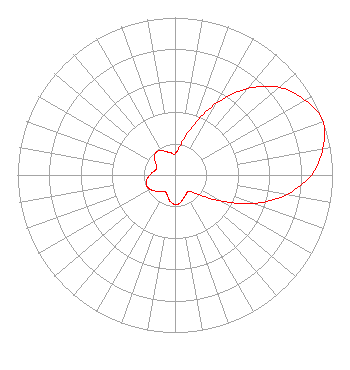
Directional Antenna
Antenna Make/Model: Scala CA5-FM/CP/RM
Antenna ID: 16149
Polarization:
| Primary Station |
| WDAQ(FM) |
Ch. 252 | Danbury, Connecticut |
|
Structure Information
Structure Registration Number 1045933
Structure Type: GTOWER
Registered To:
VB-S1 Assets, LLC
Structure Address:
0.3 Mi. Sse Of Intersection Of Carmen Hill Rd & Se Trail
Brookfield, CT
County Name: Fairfield County
ASR Issued: 09/29/2025
Date Built: 01/01/1996
Site Elevation: 218.5 m (717 ft.)
Structure Height: 151.2 m (496 ft.)
Height Overall: 152.1 m (499 ft.)
Overall Height AMSL: 370.6 m (1216 ft.)
FAA Determination: 01/13/2016
FAA Study #: 2016-ANE-12-OE
FAA Circular #: 70/7460-1L
Paint & Light FAA Chapters: 4, 8, 12
PRIOR STUDY 2009-ANE-1283-OE
41-29-36.7 N 73-25-43.9 W (NAD 83)
41-29-36.4 N 73-25-45.5 W
(Converted to NAD 27)
|
W250CH(FX) Licensee Information
The Berkshire Broadcasting Corporation
98 Mill Plain Road
Danbury, CT 06811
Phone: 203-744-4800
| 20170217ABF Applicant Information
Jerry Franklin
Date: 02/17/2017
Application Certifier
Connecticut Public Broadcasting, Inc.
1049 Asylum Avenue
Hartford, CT 06105-2411
Applicant
Charles Williamson
Digital Radio Engineering, Inc.
PO Box 920 15 Neversink Drive
Port Jervis, NY 12771
Technical Consultant
Steven C. Schaffer
Schwartz, Woods & Miller
2001 L Street, NW
Suite 900A
Washington, DC 20036-4940
|