FCCInfo.com
A Service of Cavell, Mertz & Associates, Inc.
(855) FCC-INFO
|
|
KGET from 02/01/1984 KPWR-TV from 09/27/1978 KJTV from ??? |
Virtual Channel 17 |  |
|
||||||||||||||||||||||||||||||
|
|
Status: LIC Application Accepted: 12/22/2015 License Expires: 12/01/2022 File Number: 0000007394 FCC Website Links: LMS Facility Details This Application Other KGET-TV Applications Including Superseded Applications Service Contour - Open Street Map or USGS Map (41 dBu) Service Contour - KML / Google Earth (41 dBu) Public Inspection Files Rabbit Ears Info Search for KGET-TV Site Location: 35-26-17.1 N 118-44-26.3 W (NAD 83) Site Location: 35-26-17.3 N 118-44-23.0 W (Converted to NAD 27) ERP: 135 kW Polarization: Horizontally polarized HAAT: 405 m (1329 ft.) Electrical Beam Tilt: 1.5 degrees R/C AGL: 52 m (171 ft.) R/C AMSL: 1126.4 m (3696 ft.) Site Elevation: 1074.4 m. (3525 ft.) Height Overall*: 87.7 m (288 ft.) (* As Filed In This Application, may differ from ASR Data, Below.) Directional Antenna - Antenna Make/Model: Andrew ALP16M6-HSE-25 Antenna ID: 44570 Polarization: Horizontally polarized | |||||||||||||||||||||||||||||||||
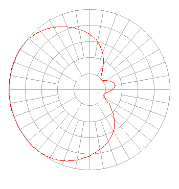
| Antenna Data for Antenna Id: 44570 KGET-TV DT File: -0000007394 Andrew - ALP16M6-HSE-25 Service: DT Standard Pattern: Y Pattern and Field Values Include a 260° Clockwise Rotation |  | |||||||||||||||||||||||||||||||||
| Azimuth | Ratio | Azimuth | Ratio | Azimuth | Ratio | Azimuth | Ratio | |||||||||||||||||||||||||||
| 0 | 0.687 | 10 | 0.597 | 20 | 0.476 | 30 | 0.340 | |||||||||||||||||||||||||||
| 40 | 0.229 | 50 | 0.188 | 60 | 0.222 | 70 | 0.287 | |||||||||||||||||||||||||||
| 80 | 0.322 | 90 | 0.287 | 100 | 0.222 | 110 | 0.188 | |||||||||||||||||||||||||||
| 120 | 0.229 | 130 | 0.340 | 140 | 0.476 | 150 | 0.597 | |||||||||||||||||||||||||||
| 160 | 0.687 | 170 | 0.758 | 180 | 0.826 | 190 | 0.890 | |||||||||||||||||||||||||||
| 200 | 0.944 | 210 | 0.979 | 220 | 0.996 | 230 | 0.999 | |||||||||||||||||||||||||||
| 240 | 0.999 | 250 | 0.999 | 260 | 1.000 | 270 | 0.999 | |||||||||||||||||||||||||||
| 280 | 0.999 | 290 | 0.999 | 300 | 0.996 | 310 | 0.979 | |||||||||||||||||||||||||||
| 320 | 0.944 | 330 | 0.890 | 340 | 0.826 | 350 | 0.758 | |||||||||||||||||||||||||||
Structure Registration Number 1015947 Structure Type: LTOWER Registered To: Nexstar Media Inc. Structure Address: Nr Breckenridge Rd 25.7 Km Ene Bakersfield, CA County Name: Kern County ASR Issued: 05/28/2021 Date Built: 08/01/1967 Site Elevation: 1074.4 m (3525 ft.) Structure Height: 60.9 m (200 ft.) Height Overall: 87.7 m (288 ft.) Overall Height AMSL: 1162.1 m (3813 ft.) FAA Determination: 11/04/2014 FAA Study #: 2014-AWP-6884-OE FAA Circular #: 70/7460-1J Paint & Light FAA Chapters: 3, 4, 5, 13 PRIOR STUDY 1997-AWP-473-OE. OM&L to remain the same as prior study = PAINT/RED LIGHTS 35-26-17.1 N 118-44-26.3 W (NAD 83) 35-26-17.3 N 118-44-23.0 W (Converted to NAD 27) |
545 E. John Carpenter Freeway Suite 700 Irving, TX 75062 Phone: 972-373-8800 Corporation | Title: SVP & General Counsel Date: 12/22/2015 Application Certifier Nexstar Broadcasting, Inc. Nexstar Broadcasting, Inc. 545 E. John Carpenter Freeway Suite 700 Irving, TX 75062 Applicant Elizabeth Ryder Nexstar Broadcasting, Inc. 545 E John Carpenter Freeway Suite 700 Irving, TX 75062 General Counsel Richard Stolpe Nexstar Broadcasting, Inc. 545 E John Carpenter Freeway Suite 700 Irving, TX 75062 Vice President - Engineering | ||||||||||||||||||||||||||||||||
|
| |||||||||||||||||||||||||||||||||