FCCInfo.com
A Service of Cavell, Mertz & Associates, Inc.
(855) FCC-INFO
|
|
K08NZ-D from 10/17/2007 KFLA-LD from 05/21/2007 K08NZ-D from 08/23/2006 K65AM from ??? |
|
|
||||||||||||||||
|
|
Status: LIC Application Accepted: 04/13/2016 License Expires: 12/01/2030 File Number: 0000010497 FCC Website Links: LMS Facility Details This Application Other KFLA-LD Applications Including Superseded Applications Service Contour - Open Street Map or USGS Map (48 dBu) Service Contour - KML / Google Earth (48 dBu) Rabbit Ears Info Search for KFLA-LD Site Location: 34-13-36.0 N 118-04-02.2 W (NAD 83) Site Location: 34-13-36.0 N 118-03-59.0 W (Converted to NAD 27) ERP: 3 kW Polarization: Horizontally polarized R/C AGL: 49 m (161 ft.) R/C AMSL: 0 m Emission Mask: Stringent Site Elevation: 1734.3 m. (5690 ft.) Height Overall*: 64 m (210 ft.) (* As Filed In This Application, may differ from ASR Data, Below.) Directional Antenna - Antenna Make/Model: RYMSA AT13 SERIES CUSTOM ARRAY Antenna ID: 116808 Polarization: Horizontally polarized | ||||||||||||||||||
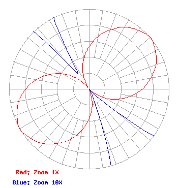
| Antenna Data for Antenna Id: 116808 KFLA-LD LD File: -0000010497 RYMSA - AT13 SERIES CUSTOM ARRAY Service: LD Standard Pattern: Y |  | ||||||||||||||||||
| Azimuth | Ratio | Azimuth | Ratio | Azimuth | Ratio | Azimuth | Ratio | ||||||||||||
| 0 | 0.525 | 10 | 0.668 | 20 | 0.785 | 30 | 0.891 | ||||||||||||
| 40 | 0.955 | 50 | 1.000 | 60 | 0.955 | 70 | 0.891 | ||||||||||||
| 80 | 0.785 | 90 | 0.668 | 100 | 0.525 | 110 | 0.377 | ||||||||||||
| 120 | 0.225 | 130 | 0.042 | 140 | 0.002 | 150 | 0.002 | ||||||||||||
| 160 | 0.042 | 170 | 0.225 | 180 | 0.377 | 190 | 0.525 | ||||||||||||
| 200 | 0.668 | 210 | 0.785 | 220 | 0.891 | 230 | 0.955 | ||||||||||||
| 240 | 1.000 | 250 | 0.955 | 260 | 0.891 | 270 | 0.785 | ||||||||||||
| 280 | 0.668 | 290 | 0.525 | 300 | 0.377 | 310 | 0.225 | ||||||||||||
| 320 | 0.042 | 330 | 0.051 | 340 | 0.234 | 350 | 0.377 | ||||||||||||
Structure Registration Number 1036897 Structure Type: Registered To: American Towers LLC Structure Address: Tower 19, Mt. Wilson Antenna Farm/25 Km Ne Of Los Angeles, CA County Name: Los Angeles County ASR Issued: 01/05/2021 Date Built: 09/30/1999 Site Elevation: 1734.3 m (5690 ft.) Structure Height: 46 m (151 ft.) Height Overall: 64 m (210 ft.) Overall Height AMSL: 1798.3 m (5900 ft.) FAA Determination: 12/10/1997 FAA Study #: 97-AWP-2875-OE Paint & Light FAA Chapters: NONE 34-13-36.0 N 118-04-02.2 W (NAD 83) 34-13-36.0 N 118-03-59.0 W (Converted to NAD 27) |
38955 Hills Tech Dr. Farmington Hills, MI 48331 Phone: 248-536-0776 Limited Liability Company | Title: Proprietor Date: 04/13/2016 Application Certifier Roy William Mayhugh 701 Perdew Ave. Ridgecrest, CA 93555 Applicant Roy William Mayhugh Proprietor 701 Perdew Ave. Ridgecrest, CA 93555 Byron St. Clair B. W. St Clair 2355 Ranch Drive Westminster, CO 80234 Engineering Consultant | |||||||||||||||||