FCCInfo.com
A Service of Cavell, Mertz & Associates, Inc.
(855) FCC-INFO
|
|
W05BV from 12/12/2013 DW05BV from 09/24/2013 W05BV from 06/21/1990 891207PL from ??? |
|
|
||||||||||||||||
|
|
Status: LIC Application Accepted: 07/06/2018 License Expires: 06/01/2029 File Number: 0000056412 FCC Website Links: LMS Facility Details This Application Other W05BV-D Applications Including Superseded Applications Service Contour - Open Street Map or USGS Map (43 dBu) Service Contour - KML / Google Earth (43 dBu) Rabbit Ears Info Search for W05BV-D Site Location: 33-27-47.4 N 88-49-01.1 W (NAD 83) Site Location: 33-27-47.0 N 88-49-00.9 W (Converted to NAD 27) ERP: 1 kW Polarization: Horizontally polarized R/C AGL: 42.7 m (140 ft.) R/C AMSL: 161.5 m (530 ft.) Emission Mask: Stringent Site Elevation: 118.8 m. (390 ft.) Height Overall*: 42.7 m (140 ft.) (* As Filed In This Application, may differ from ASR Data, Below.) Directional Antenna - Antenna Make/Model: Scala ODD891207PL Antenna ID: 21490 Polarization: Horizontally polarized | ||||||||||||||||||
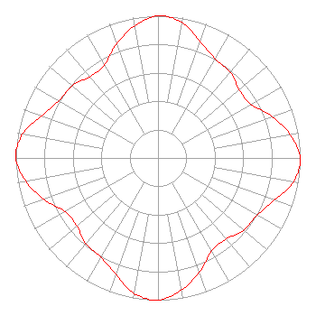
| Antenna Data for Antenna Id: 21490 W05BV-D LD File: -0000056412 Scala - ODD891207PL Service: LD Standard Pattern: Y |  | ||||||||||||||||||
| Azimuth | Ratio | Azimuth | Ratio | Azimuth | Ratio | Azimuth | Ratio | ||||||||||||
| 0 | 1.000 | 10 | 0.968 | 20 | 0.870 | 30 | 0.805 | ||||||||||||
| 40 | 0.788 | 50 | 0.745 | 60 | 0.755 | 70 | 0.853 | ||||||||||||
| 80 | 0.944 | 90 | 1.000 | 100 | 0.968 | 110 | 0.870 | ||||||||||||
| 120 | 0.805 | 130 | 0.788 | 140 | 0.745 | 150 | 0.755 | ||||||||||||
| 160 | 0.853 | 170 | 0.944 | 180 | 1.000 | 190 | 0.968 | ||||||||||||
| 200 | 0.870 | 210 | 0.805 | 220 | 0.788 | 230 | 0.745 | ||||||||||||
| 240 | 0.755 | 250 | 0.853 | 260 | 0.944 | 270 | 1.000 | ||||||||||||
| 280 | 0.968 | 290 | 0.870 | 300 | 0.805 | 310 | 0.788 | ||||||||||||
| 320 | 0.745 | 330 | 0.755 | 340 | 0.853 | 350 | 0.944 | ||||||||||||
Structure Registration Number 1066122 Structure Type: TOWER Registered To: FIRST UNITED METHODIST CHURCH Structure Address: Wilson At Lampkin Starkville, MS County Name: Oktibbeha County ASR Issued: 10/08/1999 Date Built: 08/09/1990 Site Elevation: 118.8 m (390 ft.) Structure Height: 42.7 m (140 ft.) Height Overall: 42.7 m (140 ft.) Overall Height AMSL: 161.5 m (530 ft.) FAA Determination: 05/01/1990 FAA Study #: 89-ASO-2435-OE Paint & Light FAA Chapters: NONE 33-27-47.4 N 88-49-01.1 W (NAD 83) 33-27-47.0 N 88-49-00.9 W (Converted to NAD 27) |
200 W Lampkin Starkville, MS 39759 Phone: 662-323-5722 Corporation | Title: Media Director Date: 07/06/2018 Application Certifier First United Methodist Church First United Methodist Church P.O. Box 2585 Starkville, MS 39760 Applicant Greg Best Greg Best Consulting, Inc. 16100 Outlook Ave Stilwell, KS 66085 Technical Consultant | |||||||||||||||||