FCCInfo.com
A Service of Cavell, Mertz & Associates, Inc.
(855) FCC-INFO
|
|
KSWT from 09/13/1991 KYEL-TV from 09/18/1978 KYEL from ??? |
Virtual Channel 13 |  |
|
||||||||||||||||||||||||
|
|
Status: STA – Special Temporary Authority Application Accepted: 07/20/2018 STA Expires: 10/01/2030 File Number: 0000058492 FCC Website Links: LMS Facility Details This Application Other KYMA-DT Applications Including Superseded Applications Service Contour - Open Street Map or USGS Map (36 dBu) Service Contour - KML / Google Earth (36 dBu) Public Inspection Files Rabbit Ears Info Search for KYMA-DT Site Location: 33-03-18.5 N 114-49-41.6 W (NAD 83) Site Location: 33-03-18.4 N 114-49-38.7 W (Converted to NAD 27) ERP: 50 kW Polarization: Horizontally polarized HAAT: 480 m (1575 ft.) R/C AGL: 116 m (381 ft.) R/C AMSL: 763.7 m (2506 ft.) Site Elevation: 647.7 m. (2125 ft.) Height Overall*: 122.8 m (403 ft.) (* As Filed In This Application, may differ from ASR Data, Below.) Directional Antenna - Antenna Make/Model: Jampro ODDKYELTV Antenna ID: 108296 Polarization: Horizontally polarized | |||||||||||||||||||||||||||
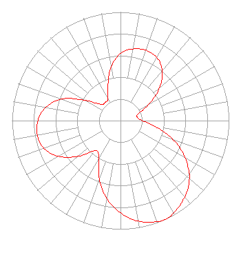
| Antenna Data for Antenna Id: 108296 KYMA-DT DT File: -0000058492 Jampro - ODDKYELTV Service: DT Standard Pattern: Y |  | |||||||||||||||||||||||||||
| Azimuth | Ratio | Azimuth | Ratio | Azimuth | Ratio | Azimuth | Ratio | |||||||||||||||||||||
| 0 | 0.620 | 10 | 0.670 | 20 | 0.690 | 30 | 0.670 | |||||||||||||||||||||
| 40 | 0.600 | 50 | 0.470 | 60 | 0.300 | 70 | 0.170 | |||||||||||||||||||||
| 80 | 0.160 | 90 | 0.200 | 100 | 0.330 | 110 | 0.520 | |||||||||||||||||||||
| 120 | 0.690 | 130 | 0.830 | 140 | 0.920 | 150 | 0.980 | |||||||||||||||||||||
| 155 | 1.000 | 160 | 0.990 | 170 | 0.940 | 180 | 0.850 | |||||||||||||||||||||
| 190 | 0.730 | 200 | 0.570 | 210 | 0.400 | 220 | 0.360 | |||||||||||||||||||||
| 230 | 0.510 | 240 | 0.660 | 250 | 0.750 | 260 | 0.780 | |||||||||||||||||||||
| 270 | 0.760 | 280 | 0.700 | 290 | 0.580 | 300 | 0.370 | |||||||||||||||||||||
| 310 | 0.230 | 320 | 0.220 | 330 | 0.230 | 340 | 0.340 | |||||||||||||||||||||
| 350 | 0.500 | |||||||||||||||||||||||||||
Structure Registration Number 1002752 Structure Type: GTOWER Registered To: Imagicomm Yuma Operations LLC Structure Address: Black Mountain 17.5 Mi N Ogilby, CA County Name: Imperial County ASR Issued: 09/27/2022 Date Built: 01/01/1977 Site Elevation: 647.7 m (2125 ft.) Structure Height: 121.9 m (400 ft.) Height Overall: 122.8 m (403 ft.) Overall Height AMSL: 770.5 m (2528 ft.) FAA Determination: 01/09/2012 FAA Study #: 2011-AWP-8122-OE FAA Circular #: 70/7460-1J Paint & Light FAA Chapters: 3, 4, 5, 13 PRIOR STUDY 1996-AWP-2538-OE 33-03-18.5 N 114-49-41.6 W (NAD 83) 33-03-18.4 N 114-49-38.7 W (Converted to NAD 27) |
3000 Worldreach Drive Indian Land, SC 29707 Phone: 803-578-1418 Limited Liability Company | Title: Chief Technology Officer Date: 07/20/2018 Application Certifier Blackhawk Broadcasting LLC Blackhawk Broadcasting LLC 2111 University Park Drive Suite 605 Okemos, MI 48864 Applicant Ron Sweatte Sweatte Northwest Broadcasting, Inc. 2111 University Park Drive, Suite 650 Okemos, MI 48864 Dennis P Corbett P Corbett Telecommunications Law Professionals PLLC 1025 Connecticut Avenue NW Suite 1011 Washington, DC 20036 | ||||||||||||||||||||||||||
|
| |||||||||||||||||||||||||||