FCCInfo.com
A Service of Cavell, Mertz & Associates, Inc.
(855) FCC-INFO
|
|
K43DU-D from 03/22/2010 K43DU from 11/19/1991 910503AQ from ??? |
|
|
||||||||||||||||
|
|
Status: LIC Application Accepted: 10/29/2018 License Expires: 04/01/2030 File Number: 0000063139 FCC Website Links: LMS Facility Details This Application Other K24MP-D Applications Including Superseded Applications Service Contour - Open Street Map or USGS Map (51 dBu) Service Contour - KML / Google Earth (51 dBu) Rabbit Ears Info Search for K24MP-D Site Location: 46-00-27.0 N 112-26-33.0 W (NAD 83) Site Location: 46-00-27.3 N 112-26-29.9 W (Converted to NAD 27) ERP: 4.55 kW Polarization: Elliptically polarized Electrical Beam Tilt: 1.75 degrees R/C AGL: 15.2 m (50 ft.) R/C AMSL: 2531.2 m (8304 ft.) Emission Mask: Simple Site Elevation: 2516 m. (8255 ft.) Height Overall*: 62 m (203 ft.) (* As Filed In This Application, may differ from ASR Data, Below.) Directional Antenna - Antenna Make/Model: Electronics Research Inc. AL80C-24-ME Antenna ID: 1004273 Polarization: Elliptically polarized | ||||||||||||||||||
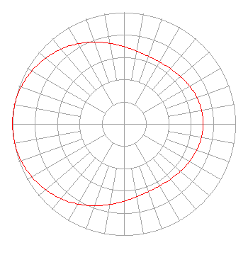
| Antenna Data for Antenna Id: 1004273 K24MP-D LD File: -0000063139 Electronics Research Inc. - AL80C-24-ME Service: LD Standard Pattern: N |  | ||||||||||||||||||
| Azimuth | Ratio | Azimuth | Ratio | Azimuth | Ratio | Azimuth | Ratio | ||||||||||||
| 0 | 0.694 | 10 | 0.663 | 20 | 0.645 | 30 | 0.641 | ||||||||||||
| 40 | 0.647 | 50 | 0.661 | 60 | 0.679 | 70 | 0.694 | ||||||||||||
| 80 | 0.705 | 90 | 0.709 | 100 | 0.705 | 110 | 0.694 | ||||||||||||
| 120 | 0.678 | 130 | 0.661 | 140 | 0.647 | 150 | 0.641 | ||||||||||||
| 160 | 0.645 | 170 | 0.663 | 180 | 0.694 | 190 | 0.734 | ||||||||||||
| 200 | 0.781 | 210 | 0.829 | 220 | 0.876 | 230 | 0.918 | ||||||||||||
| 240 | 0.953 | 250 | 0.979 | 260 | 0.995 | 270 | 1.000 | ||||||||||||
| 280 | 0.995 | 290 | 0.979 | 300 | 0.953 | 310 | 0.918 | ||||||||||||
| 320 | 0.876 | 330 | 0.829 | 340 | 0.781 | 350 | 0.734 | ||||||||||||
Structure Registration Number 1001059 Structure Type: TOWER Registered To: Scripps Broadcasting Holdings LLC Structure Address: Xl Heights 3.23 Mi E Butte, MT County Name: Jefferson County ASR Issued: 05/02/2019 Date Built: 08/01/1956 Site Elevation: 2516 m (8255 ft.) Structure Height: 37 m (121 ft.) Height Overall: 62 m (203 ft.) Overall Height AMSL: 2578 m (8458 ft.) Paint & Light FAA Chapters: 1, 3, 11, 21 46-00-27.0 N 112-26-33.0 W (NAD 83) 46-00-27.3 N 112-26-29.9 W (Converted to NAD 27) |
Visual Communications Bldg. 183 Bozeman, MT 59717 Phone: 406-994-3437 Government Entity | Title: Director and General Manager Date: 10/29/2018 Application Certifier Montana State University Montana State University Visual Communications Bldg. 183 Bozeman, MT 59717 Applicant Margaret L. Miller Gray Miller Persh LLP 1200 New Hampshire Ave., NW Suite 410 Washington, DC 20036 | |||||||||||||||||