FCCInfo.com
A Service of Cavell, Mertz & Associates, Inc.
(855) FCC-INFO
|
|
810720KF from ??? |
Virtual Channel 54 |  |
|
|||||||||||||||||
|
|
Status: LIC Application Accepted: 12/06/2018 License Expires: 04/01/2029 File Number: 0000064021 FCC Website Links: LMS Facility Details This Application Other WXTX Applications Including Superseded Applications Service Contour - Open Street Map or USGS Map (41 dBu) Service Contour - KML / Google Earth (41 dBu) Public Inspection Files Rabbit Ears Info Search for WXTX Site Location: 32-27-41.0 N 84-52-43.0 W (NAD 83) Site Location: 32-27-40.5 N 84-52-43.3 W (Converted to NAD 27) ERP: 200 kW Polarization: Elliptically polarized HAAT: 339 m (1112 ft.) Electrical Beam Tilt: 1.0 degree R/C AGL: 339.9 m (1115 ft.) R/C AMSL: 451.9 m (1483 ft.) Site Elevation: 112 m. (367 ft.) Height Overall*: 348 m (1142 ft.) (* As Filed In This Application, may differ from ASR Data, Below.) Directional Antenna - Antenna Make/Model: DIELECTRIC TFU-16JTH/VP-R P230 Antenna ID: 1004404 Polarization: Elliptically polarized | ||||||||||||||||||||
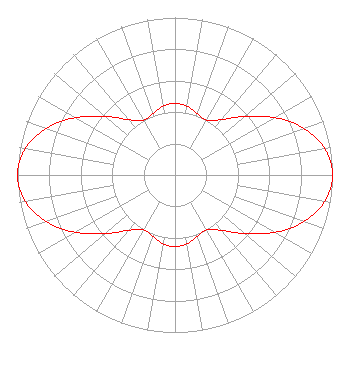
| Antenna Data for Antenna Id: 1004404 WXTX DT File: -0000064021 DIELECTRIC - TFU-16JTH/VP-R P230 Service: DT Standard Pattern: N |  | ||||||||||||||||||||
| Azimuth | Ratio | Azimuth | Ratio | Azimuth | Ratio | Azimuth | Ratio | ||||||||||||||
| 0 | 0.456 | 10 | 0.443 | 20 | 0.413 | 30 | 0.403 | ||||||||||||||
| 40 | 0.458 | 50 | 0.578 | 60 | 0.729 | 70 | 0.868 | ||||||||||||||
| 80 | 0.965 | 90 | 1.000 | 100 | 0.965 | 110 | 0.868 | ||||||||||||||
| 120 | 0.729 | 130 | 0.578 | 140 | 0.458 | 150 | 0.403 | ||||||||||||||
| 160 | 0.413 | 170 | 0.443 | 180 | 0.456 | 190 | 0.443 | ||||||||||||||
| 200 | 0.413 | 210 | 0.403 | 220 | 0.458 | 230 | 0.578 | ||||||||||||||
| 240 | 0.729 | 250 | 0.868 | 260 | 0.965 | 270 | 1.000 | ||||||||||||||
| 280 | 0.965 | 290 | 0.868 | 300 | 0.729 | 310 | 0.578 | ||||||||||||||
| 320 | 0.458 | 330 | 0.403 | 340 | 0.413 | 350 | 0.443 | ||||||||||||||
Structure Registration Number 1019105 Structure Type: GTOWER Registered To: WXTX License Subsidiary, LLC Structure Address: Buena Vista Rd 1.95 Mi E Of Floyd Rd Columbus, GA County Name: Muscogee County ASR Issued: 06/09/2014 Date Built: 05/24/1983 Site Elevation: 112 m (367 ft.) Structure Height: 335 m (1099 ft.) Height Overall: 348 m (1142 ft.) Overall Height AMSL: 460 m (1509 ft.) FAA Determination: 06/06/2014 FAA Study #: 2013-ASO-11188-OE FAA Circular #: 70/7460-1K Paint & Light FAA Chapters: 3, 4, 5, 12 PRIOR STUDY 1996-ASO-3390-OE 32-27-41.0 N 84-52-43.0 W (NAD 83) 32-27-40.5 N 84-52-43.3 W (Converted to NAD 27) |
2131 Ayrsley Town Boulevard Suite 300 Charlotte, NC 28273 Phone: 704-643-4148 Limited Liability Company | Title: Manager Date: 12/06/2018 Application Certifier WXTX License Subsidiary, LLC WXTX License Subsidiary, LLC 2131 Ayrsley Town Boulevard Suite 300 Charlotte, NC 28273 Applicant Daniel A. Kirkpatrick, Esq. Fletcher, Heald & Hildreth, PLC Fletcher, Heald & Hildreth, P.L.C. 1300 N. 17th Street - Eleventh Floor Arlington, VA 22209 Robert E Thurber, Jr Raycom Media, Inc. 201 Monroe Street Montgomery, AL 36104 Technical Consultant | |||||||||||||||||||
| |||||||||||||||||||||