FCCInfo.com
A Service of Cavell, Mertz & Associates, Inc.
(855) FCC-INFO
|
|
KFXP from 06/01/1998 KBDL from 03/20/1998 951215KJ from ??? |
Virtual Channel 31 |  |
|
|||||||||||||||||
|
|
Status: LIC Application Accepted: 03/07/2019 License Expires: 10/01/2030 File Number: 0000068416 FCC Website Links: LMS Facility Details This Application Other KVUI Applications Including Superseded Applications Service Contour - Open Street Map or USGS Map (41 dBu) Service Contour - KML / Google Earth (41 dBu) Public Inspection Files Rabbit Ears Info Search for KVUI Site Location: 42-51-50.1 N 112-31-13.3 W (NAD 83) Site Location: 42-51-50.4 N 112-31-10.4 W (Converted to NAD 27) ERP: 313 kW Polarization: Elliptically polarized HAAT: 331.1 m (1086 ft.) Electrical Beam Tilt: 1.0 degree R/C AGL: 86.4 m (283 ft.) R/C AMSL: 1857 m (6093 ft.) Site Elevation: 1770.6 m. (5809 ft.) Height Overall*: 92.4 m (303 ft.) (* As Filed In This Application, may differ from ASR Data, Below.) Directional Antenna - Antenna Make/Model: Alive ATC-BCSE20C2S-U Antenna ID: 1002662 Polarization: Elliptically polarized | ||||||||||||||||||||
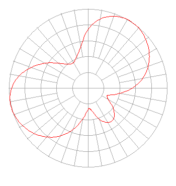
| Antenna Data for Antenna Id: 1002662 KVUI DT File: -0000068416 Alive - ATC-BCSE20C2S-U Service: DT Standard Pattern: Y |  | ||||||||||||||||||||
| Azimuth | Ratio | Azimuth | Ratio | Azimuth | Ratio | Azimuth | Ratio | ||||||||||||||
| 0 | 0.740 | 10 | 0.883 | 20 | 0.964 | 30 | 0.998 | ||||||||||||||
| 33 | 1.000 | 40 | 0.991 | 50 | 0.953 | 60 | 0.892 | ||||||||||||||
| 70 | 0.809 | 80 | 0.701 | 90 | 0.563 | 100 | 0.402 | ||||||||||||||
| 110 | 0.276 | 114 | 0.264 | 120 | 0.300 | 130 | 0.420 | ||||||||||||||
| 140 | 0.505 | 150 | 0.504 | 160 | 0.419 | 170 | 0.299 | ||||||||||||||
| 176 | 0.263 | 180 | 0.276 | 190 | 0.402 | 200 | 0.562 | ||||||||||||||
| 210 | 0.701 | 220 | 0.809 | 230 | 0.891 | 240 | 0.953 | ||||||||||||||
| 250 | 0.991 | 260 | 0.998 | 270 | 0.964 | 280 | 0.883 | ||||||||||||||
| 290 | 0.759 | 300 | 0.626 | 310 | 0.486 | 320 | 0.392 | ||||||||||||||
| 330 | 0.369 | 340 | 0.420 | 350 | 0.524 | ||||||||||||||||
Structure Registration Number 1239956 Structure Type: TOWER Registered To: MM Shirin Properties, LLC Structure Address: Howard Mt. Lot 12, Power County Pocatello, ID County Name: Power County ASR Issued: 03/12/2019 Date Built: 11/06/2003 Site Elevation: 1770.6 m (5809 ft.) Structure Height: 91.4 m (300 ft.) Height Overall: 92.4 m (303 ft.) Overall Height AMSL: 1863 m (6112 ft.) FAA Determination: 06/30/2003 FAA Study #: 2003-ANM-1166-OE FAA Circular #: 70/7460-1K Paint & Light FAA Chapters: 3, 4, 5, 12 42-51-50.1 N 112-31-13.3 W (NAD 83) 42-51-50.4 N 112-31-10.4 W (Converted to NAD 27) |
P.O. Box 15009 Fresno, CA 93702 Phone: 866-436-6388 Limited Liability Company | Title: Member Date: 03/07/2019 Application Certifier Ventura Media Communications, LLC Ventura Media Communications, LLC 3619 E. Ventura Ave. Fresno, CA 93702 Applicant William Jeffrey Reynolds Du Treil, Lundin & Rackley, Inc. 3135 Southgate Circle Sarasota, FL 34239 Technical Consultant Kathleen Victory Fletcher Heald & Hildreth, PLC 1300 N 17th Street 11th Floor Arlington, VA 22209 FCC Counsel | |||||||||||||||||||