FCCInfo.com
A Service of Cavell, Mertz & Associates, Inc.
(855) FCC-INFO
|
|
KCRP-CA from 11/13/2001 KCRP-LP from 06/14/2001 K41FO from 05/08/2000 K22BH from 07/31/1986 810217AI from ??? |
Virtual Channel 41 |
|
||||||||||||||||||
|
|
Status: LIC Application Accepted: 03/20/2019 License Expires: 08/01/2022 File Number: 0000068614 FCC Website Links: LMS Facility Details This Application Other KCRP-CD Applications Including Superseded Applications Service Contour - Open Street Map or USGS Map (51 dBu) Service Contour - KML / Google Earth (51 dBu) Public Inspection Files Rabbit Ears Info Search for KCRP-CD Site Location: 27-46-11.1 N 97-26-55.9 W (NAD 83) Site Location: 27-46-10.0 N 97-26-54.9 W (Converted to NAD 27) ERP: 15 kW Polarization: Circularly polarized Electrical Beam Tilt: 1.5 degrees R/C AGL: 95 m (312 ft.) R/C AMSL: 107.5 m (353 ft.) Emission Mask: Full Service Site Elevation: 12.5 m. (41 ft.) Height Overall*: 132.5 m (435 ft.) (* As Filed In This Application, may differ from ASR Data, Below.) Directional Antenna - Antenna Make/Model: Electronics Research Inc. ALP12L6-HSER Antenna ID: 1004754 Polarization: Circularly polarized | ||||||||||||||||||||
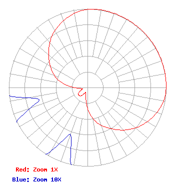
| Antenna Data for Antenna Id: 1004754 KCRP-CD DC File: -0000068614 Electronics Research Inc. - ALP12L6-HSER Service: DC Standard Pattern: N Pattern and Field Values Include a 48° Clockwise Rotation |  | ||||||||||||||||||||
| Azimuth | Ratio | Azimuth | Ratio | Azimuth | Ratio | Azimuth | Ratio | ||||||||||||||
| 8 | 1.000 | 18 | 1.000 | 28 | 1.000 | 38 | 1.000 | ||||||||||||||
| 48 | 1.000 | 58 | 1.000 | 68 | 1.000 | 78 | 1.000 | ||||||||||||||
| 88 | 1.000 | 98 | 0.988 | 108 | 0.946 | 118 | 0.886 | ||||||||||||||
| 128 | 0.815 | 138 | 0.725 | 148 | 0.624 | 158 | 0.529 | ||||||||||||||
| 168 | 0.428 | 178 | 0.293 | 188 | 0.146 | 198 | 0.067 | ||||||||||||||
| 208 | 0.085 | 218 | 0.136 | 228 | 0.147 | 238 | 0.136 | ||||||||||||||
| 248 | 0.085 | 258 | 0.067 | 268 | 0.146 | 278 | 0.293 | ||||||||||||||
| 288 | 0.428 | 298 | 0.529 | 308 | 0.624 | 318 | 0.725 | ||||||||||||||
| 328 | 0.815 | 338 | 0.886 | 348 | 0.946 | 358 | 0.988 | ||||||||||||||
Structure Registration Number 1211244 [ASR Heights Differ from KCRP-CD Application] Structure Type: GTOWER Registered To: Crown Castle Towers 06-2 LLC Structure Address: 1100 Navigation Blvd.-1 Mile South Of State Hwy 44 Corpus Christi, TX County Name: Nueces County ASR Issued: 01/27/2026 Date Built: 03/01/2000 Site Elevation: 12.5 m (41 ft.) Structure Height: 132.5 m (435 ft.) Height Overall: 137.5 m (451 ft.) Overall Height AMSL: 150 m (492 ft.) FAA Determination: 12/12/2022 FAA Study #: 2022-ASW-4807-OE FAA Circular #: 70/7460-1L Paint & Light FAA Chapters: 4, 8, 12 PRIOR STUDIES 2000-ASW-109-OE / 2019-ASW-65-OE 27-46-11.1 N 97-26-55.9 W (NAD 83) 27-46-10.0 N 97-26-54.9 W (Converted to NAD 27) |
1 Estrella Way Burbank, CA 91504 Phone: 310-447-3870 Limited Liability Company | Title: Chief Executive Officer Date: 03/20/2019 Application Certifier Entravision Holdings, LLC 2425 Olympic Blvd Ste 6000 W Santa Monica, CA 90404 Applicant Barry A. Friedman Thompson Hine LLP Suite 700 1919 M Street, N.W. Washington, DC 20036 W. Jeffrey Reynolds Dutreil, Lundin & Rackley, Inc. 3135 Southgate Circle Sarasota, FL 34239 Consulting Engineer | |||||||||||||||||||