|
| WXEL-TV Service: DT - Digital TV | | Channel: 29 Zone: 3 |
| Boynton Beach, Florida |
| Nielsen DMA™: West Palm Beach - Ft. Pierce |
| Network: PBS |
| Virtual Channel: 42 |
| DTV TSID: 729 |
| Facility ID: 61084 | | FRN: 0001822923 |
WXEL-TV is a channel sharing guest of WPBT, Miami, Florida
Status: LIC
Application Accepted: 03/13/2019
License Expires: 02/01/2029
File Number: 0000068486
FCC Website Links:
LMS Facility Details
This Application
Other WXEL-TV Applications
Including Superseded Applications
Service Contour - Open Street Map or USGS Map (41 dBu)
Service Contour - KML / Google Earth (41 dBu)
Public Inspection Files
Rabbit Ears Info Search for WXEL-TV
Site Location: 25-57-31.0 N 80-12-43.0 W (NAD 83)
Site Location: 25-57-29.7 N 80-12-43.8 W (Converted to NAD 27)
ERP: 1000 kW
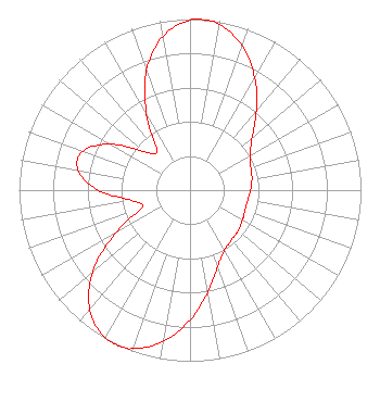
Polarization: Elliptically polarized
HAAT: 306 m (1004 ft.)
Electrical Beam Tilt: 1.0 degree
R/C AGL: 306 m (1004 ft.)
R/C AMSL: 307.9 m (1010 ft.)
Site Elevation: 1.9 m. (6 ft.)
Height Overall*: 317.9 m (1043 ft.)
(* As Filed In This Application, may differ from ASR Data, Below.)
Directional Antenna - Antenna Make/Model: DIELECTRIC TFU-18GTH/VP-R P250BNT
Antenna ID: 1001252
Polarization: Elliptically polarized
| Associated Translators |
| W31DC-D |
Ch. 31 | Fort Pierce, Florida |
|
Structure Information
Structure Registration Number 1029604
Structure Type: GTOWER
Registered To:
American Towers LLC
Structure Address:
695 Nw 199th St
Miami, FL
County Name: Miami-Dade County
ASR Issued: 03/30/2022
Date Built: 11/25/1977
Site Elevation: 1.9 m (6 ft.)
Structure Height: 299.2 m (982 ft.)
Height Overall: 317.9 m (1043 ft.)
Overall Height AMSL: 319.8 m (1049 ft.)
FAA Determination: 10/09/2014
FAA Study #: 2014-ASO-8960-OE
FAA Circular #: 70/7460-1K
Paint & Light FAA Chapters: 3, 4, 5, 12
25-57-31.0 N 80-12-43.0 W (NAD 83)
25-57-29.7 N 80-12-43.8 W
(Converted to NAD 27)
|
WXEL-TV Licensee Information
South Florida PBS, Inc.
14901 N.E. 20th Ave.
Miami, FL 33181
Phone: 305-949-8321
Not-for-Profit | 0000068486 Applicant Information
Application Certifier
South Florida PBS, Inc.
South Florida PBS, Inc.
14901 N.E. 20th Ave.
Miami, FL 33181
Applicant
Gene Talley
South Florida PBS, Inc.
14901 NE 20th Ave
Miami, FL 33181
VP of Engineering
|