FCCInfo.com
A Service of Cavell, Mertz & Associates, Inc.
(855) FCC-INFO
|
|
|
Virtual Channel 10 |
|
||||||||||||||||||||||||||||||||||
|
|
WMVS is a channel sharing guest of WMVS, Milwaukee, Wisconsin WMVS, Milwaukee, Wisconsin WMVT, Milwaukee, Wisconsin Status: LIC Application Accepted: 05/21/2019 License Expires: 12/01/2029 File Number: 0000073033 FCC Website Links: LMS Facility Details This Application Other WMVS Applications Including Superseded Applications Service Contour - Open Street Map or USGS Map (36 dBu) Service Contour - KML / Google Earth (36 dBu) Public Inspection Files Rabbit Ears Info Search for WMVS Site Location: 43-05-48.0 N 87-54-18.0 W (NAD 83) Site Location: 43-05-48.0 N 87-54-17.7 W (Converted to NAD 27) ERP: 32 kW Polarization: Elliptically polarized HAAT: 310 m (1017 ft.) Electrical Beam Tilt: 1.5 degrees R/C AGL: 315.7 m (1036 ft.) R/C AMSL: 508 m (1667 ft.) Site Elevation: 192.3 m. (631 ft.) Height Overall*: 335.6 m (1101 ft.) (* As Filed In This Application, may differ from ASR Data, Below.) Directional Antenna - Antenna Make/Model: Electronics Research Inc. ATW7V6-CTCX-8 Antenna ID: 111438 Polarization: Elliptically polarized | ||||||||||||||||||||||||||||||||||||
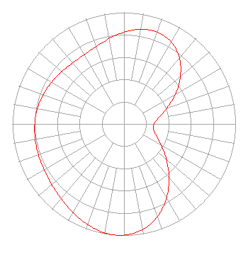
| Antenna Data for Antenna Id: 111438 WMVS DX File: -0000073033 Electronics Research Inc. - ATW7V6-CTCX-8 Service: DX Standard Pattern: Y |  | ||||||||||||||||||||||||||||||||||||
| Azimuth | Ratio | Azimuth | Ratio | Azimuth | Ratio | Azimuth | Ratio | ||||||||||||||||||||||||||||||
| 0 | 0.822 | 10 | 0.862 | 20 | 0.875 | 30 | 0.849 | ||||||||||||||||||||||||||||||
| 40 | 0.772 | 50 | 0.659 | 60 | 0.532 | 70 | 0.407 | ||||||||||||||||||||||||||||||
| 80 | 0.315 | 90 | 0.269 | 100 | 0.267 | 110 | 0.308 | ||||||||||||||||||||||||||||||
| 120 | 0.383 | 130 | 0.496 | 140 | 0.627 | 150 | 0.763 | ||||||||||||||||||||||||||||||
| 160 | 0.882 | 170 | 0.963 | 180 | 0.997 | 184 | 1.000 | ||||||||||||||||||||||||||||||
| 190 | 0.992 | 200 | 0.958 | 210 | 0.916 | 220 | 0.876 | ||||||||||||||||||||||||||||||
| 230 | 0.848 | 240 | 0.826 | 250 | 0.816 | 260 | 0.808 | ||||||||||||||||||||||||||||||
| 270 | 0.800 | 280 | 0.788 | 290 | 0.770 | 300 | 0.748 | ||||||||||||||||||||||||||||||
| 310 | 0.728 | 320 | 0.714 | 330 | 0.715 | 340 | 0.736 | ||||||||||||||||||||||||||||||
| 350 | 0.774 | ||||||||||||||||||||||||||||||||||||
Structure Registration Number 1045308 Structure Type: TOWER Registered To: WCGV Licensee, LLC Structure Address: 4400 N Humboldt Ave Milwaukee, WI County Name: Milwaukee County ASR Issued: 01/11/2017 Date Built: 11/05/1980 Site Elevation: 192.3 m (631 ft.) Structure Height: 335.6 m (1101 ft.) Height Overall: 335.6 m (1101 ft.) Overall Height AMSL: 527.9 m (1732 ft.) FAA Determination: 04/15/1998 FAA Study #: 98-AGL-1610-OE Paint & Light FAA Chapters: 1, 3, 8, 17, 21 REF STUDY #97-AGL-5272-OE. 43-05-48.0 N 87-54-18.0 W (NAD 83) 43-05-48.0 N 87-54-17.7 W (Converted to NAD 27) |
1036 North 8th Street Milwaukee, WI 53233 Phone: 414-297-8028 Government Entity | Title: General Manager, Milwaukee PBS Date: 05/21/2019 Application Certifier Milwaukee Area Technical College District Board Milwaukee Area Technical College District Board 1036 North 8th Street Milwaukee, WI 53233 Applicant Greg Best Greg Best Consulting, Inc. 16100 Outlook Stilwell, KS 66085 Consulting Engineer Barry S. Persh Gray Miller Persh LLP 2233 Wisconsin Ave., NW Suite 226 Washington, DC 20007 | |||||||||||||||||||||||||||||||||||
|
| ||||||||||||||||||||||||||||||||||||