FCCInfo.com
A Service of Cavell, Mertz & Associates, Inc.
(855) FCC-INFO
|
|
KGHB-CA from 02/19/2001 KGHB-LP from 04/18/1997 KCEC-LP from 11/20/1995 K27DU from 10/25/1991 K26DI from 08/21/1990 890310NC from ??? |
|
|
||||||||||||||||
|
|
Status: LIC Application Accepted: 05/15/2019 License Expires: 04/01/2030 File Number: 0000072765 FCC Website Links: LMS Facility Details This Application Other KGHB-CD Applications Including Superseded Applications Service Contour - Open Street Map or USGS Map (51 dBu) Service Contour - KML / Google Earth (51 dBu) Public Inspection Files Rabbit Ears Info Search for KGHB-CD Site Location: 38-22-21.4 N 104-33-39.9 W (NAD 83) Site Location: 38-22-21.4 N 104-33-38.0 W (Converted to NAD 27) ERP: 15 kW Polarization: Elliptically polarized Electrical Beam Tilt: 1.0 degree R/C AGL: 24 m (79 ft.) R/C AMSL: 1648.6 m (5409 ft.) Emission Mask: Stringent Site Elevation: 1624.6 m. (5330 ft.) Height Overall*: 96 m (315 ft.) (* As Filed In This Application, may differ from ASR Data, Below.) Directional Antenna - Antenna Make/Model: DIELECTRIC TLP-8 SP/VP-R Antenna ID: 1005009 Polarization: Elliptically polarized | ||||||||||||||||||
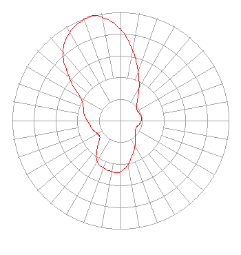
| Antenna Data for Antenna Id: 1005009 KGHB-CD DC File: -0000072765 DIELECTRIC - TLP-8 SP/VP-R Service: DC Standard Pattern: N |  | ||||||||||||||||||
| Azimuth | Ratio | Azimuth | Ratio | Azimuth | Ratio | Azimuth | Ratio | ||||||||||||
| 0 | 0.840 | 10 | 0.652 | 20 | 0.477 | 30 | 0.342 | ||||||||||||
| 40 | 0.242 | 50 | 0.191 | 60 | 0.180 | 70 | 0.187 | ||||||||||||
| 80 | 0.195 | 90 | 0.192 | 100 | 0.179 | 110 | 0.162 | ||||||||||||
| 120 | 0.160 | 130 | 0.180 | 140 | 0.217 | 150 | 0.269 | ||||||||||||
| 160 | 0.328 | 170 | 0.408 | 180 | 0.470 | 185 | 0.484 | ||||||||||||
| 190 | 0.475 | 200 | 0.463 | 210 | 0.432 | 220 | 0.335 | ||||||||||||
| 230 | 0.249 | 240 | 0.243 | 250 | 0.266 | 260 | 0.280 | ||||||||||||
| 270 | 0.305 | 280 | 0.341 | 290 | 0.364 | 300 | 0.427 | ||||||||||||
| 310 | 0.619 | 320 | 0.826 | 330 | 0.937 | 340 | 0.989 | ||||||||||||
| 345 | 1.000 | 350 | 0.964 | ||||||||||||||||
Structure Registration Number 1237865 Structure Type: TOWER Registered To: Pueblo Tall Tower Company Structure Address: Nw 1/4 Ne 1/4 Section 28, Township 19 S, Range 64 W Pueblo, CO County Name: Pueblo County ASR Issued: 03/04/2003 Date Built: 01/01/1982 Site Elevation: 1624.6 m (5330 ft.) Structure Height: 91.4 m (300 ft.) Height Overall: 96 m (315 ft.) Overall Height AMSL: 1720.6 m (5645 ft.) FAA Determination: 02/20/2003 FAA Study #: 2003-ANM-490-OE FAA Circular #: 70/7460-1K Paint & Light FAA Chapters: 4, 8, 12 Removed expiration date from determination. Scenario 1./jjs/case#635066 38-22-21.4 N 104-33-39.9 W (NAD 83) 38-22-21.4 N 104-33-38.0 W (Converted to NAD 27) |
1 Estrella Way Burbank, CA 91504 Phone: 310-447-3870 Limited Liability Company | Title: Chief Executive Officer Date: 05/15/2019 Application Certifier Entravision Holdings, LLC Entravision Holdings, LLC 2425 Olympic Blvd Ste 6000 W Santa Monica, CA 90404 Applicant Barry A. Friedman Thompson Hine LLP Suite 700 1919 M Street, N.W. Washington, DC 20036 W. Jeffrey Reynolds Dutreil, Lundin & Rackley, Inc. 3135 Southgate Circle Sarasota, FL 34239 Consulting Engineer | |||||||||||||||||