FCCInfo.com
A Service of Cavell, Mertz & Associates, Inc.
(855) FCC-INFO
|
|
KEZI from 01/31/1979 |
Virtual Channel 9 |  |
|
|||||||||||||||||||||||||||||||||||||||||||||||||||||||||||||||||||||
|
|
Status: LIC Application Accepted: 06/27/2019 License Expires: 02/01/2031 File Number: 0000075069 FCC Website Links: LMS Facility Details This Application Other KEZI Applications Including Superseded Applications Mailing Address Correspondence for KEZI Correspondence related to application 0000075069 Service Contour - Open Street Map or USGS Map (36 dBu) Service Contour - KML / Google Earth (36 dBu) Public Inspection Files History Cards for KEZI Rabbit Ears Info Search for KEZI Site Location: 44-17-27.4 N 123-32-22.3 W (NAD 83) Site Location: 44-17-28.0 N 123-32-17.9 W (Converted to NAD 27) ERP: 21.6 kW Polarization: Horizontally polarized HAAT: 738.0 m (2421 ft.) Electrical Beam Tilt: 1.75 degrees R/C AGL: 56.1 m (184 ft.) R/C AMSL: 1054.6 m (3460 ft.) Site Elevation: 998.5 m. (3276 ft.) Height Overall*: 60.9 m (200 ft.) (* As Filed In This Application, may differ from ASR Data, Below.) Directional Antenna - Antenna Make/Model: Electronics Research Inc. ALV4H7-HSOC-9 Antenna ID: 1005168 Polarization: Horizontally polarized
| ||||||||||||||||||||||||||||||||||||||||||||||||||||||||||||||||||||||||
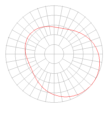
| Antenna Data for Antenna Id: 1005168 KEZI DT File: -0000075069 Electronics Research Inc. - ALV4H7-HSOC-9 Service: DT Standard Pattern: N Pattern and Field Values Include a 126° Clockwise Rotation |  | ||||||||||||||||||||||||||||||||||||||||||||||||||||||||||||||||||||||||
| Azimuth | Ratio | Azimuth | Ratio | Azimuth | Ratio | Azimuth | Ratio | ||||||||||||||||||||||||||||||||||||||||||||||||||||||||||||||||||
| 6 | 0.549 | 16 | 0.552 | 26 | 0.571 | 36 | 0.608 | ||||||||||||||||||||||||||||||||||||||||||||||||||||||||||||||||||
| 46 | 0.660 | 56 | 0.719 | 66 | 0.782 | 76 | 0.842 | ||||||||||||||||||||||||||||||||||||||||||||||||||||||||||||||||||
| 86 | 0.894 | 96 | 0.938 | 106 | 0.970 | 116 | 0.991 | ||||||||||||||||||||||||||||||||||||||||||||||||||||||||||||||||||
| 126 | 1.000 | 136 | 0.995 | 146 | 0.979 | 156 | 0.950 | ||||||||||||||||||||||||||||||||||||||||||||||||||||||||||||||||||
| 166 | 0.911 | 176 | 0.861 | 186 | 0.805 | 196 | 0.745 | ||||||||||||||||||||||||||||||||||||||||||||||||||||||||||||||||||
| 206 | 0.685 | 216 | 0.631 | 226 | 0.588 | 236 | 0.560 | ||||||||||||||||||||||||||||||||||||||||||||||||||||||||||||||||||
| 246 | 0.551 | 256 | 0.557 | 266 | 0.575 | 276 | 0.596 | ||||||||||||||||||||||||||||||||||||||||||||||||||||||||||||||||||
| 286 | 0.616 | 296 | 0.631 | 306 | 0.638 | 316 | 0.634 | ||||||||||||||||||||||||||||||||||||||||||||||||||||||||||||||||||
| 326 | 0.624 | 336 | 0.604 | 346 | 0.582 | 356 | 0.562 | ||||||||||||||||||||||||||||||||||||||||||||||||||||||||||||||||||
Structure Registration Number 1205567 Structure Type: Registered To: StratCap Wireless Group Structure Address: E Prairie Mtn Horton, OR County Name: Benton County ASR Issued: 07/03/2024 Date Built: 11/10/2000 Site Elevation: 998.5 m (3276 ft.) Structure Height: 60.9 m (200 ft.) Height Overall: 60.9 m (200 ft.) Overall Height AMSL: 1059.4 m (3476 ft.) FAA Determination: 09/30/1999 FAA Study #: 99-ANM-1127-OE FAA Circular #: 70/7460-1J Paint & Light FAA Chapters: 4, 5, 13 Removed expiration date from determination. Scenario 1./jjs/case#635066 44-17-27.4 N 123-32-22.3 W (NAD 83) 44-17-28.0 N 123-32-17.9 W (Converted to NAD 27) |
1925 Century Park East 10th Floor Los Angeles, CA 90067 Phone: 310-277-3500 Limited Liability Company | Title: Ceo Date: 06/27/2019 Application Certifier Oregon TV License Company, LLC 3282 Northside Parkway Suite 275 Atlanta, GA 30327 Applicant John M. Burgett, Esq Wiley Rein LLP 1776 K Street, N.W. Washington, DC 20006 Joseph M. Davis, P.E. Chesapeake RF Consultants, LLC 207 Old Dominion Road Yorktown, VA 23692 Consulting Engineer Keane Laguatan Kezi 2975 Chad Dr. Eugene, OR 97408 Director of Technology | |||||||||||||||||||||||||||||||||||||||||||||||||||||||||||||||||||||||
|
| ||||||||||||||||||||||||||||||||||||||||||||||||||||||||||||||||||||||||