FCCInfo.com
A Service of Cavell, Mertz & Associates, Inc.
(855) FCC-INFO
|
|
WWPC-TV from 07/01/1986 WOPC from ??? |
Virtual Channel 23 |  |
|
|||||||||||||||||||||
|
|
Status: LIC Application Accepted: 02/04/2020 License Expires: 08/01/2031 File Number: 0000105303 FCC Website Links: LMS Facility Details This Application Other WATM-TV Applications Including Superseded Applications Service Contour - Open Street Map or USGS Map (41 dBu) Service Contour - KML / Google Earth (41 dBu) Public Inspection Files Rabbit Ears Info Search for WATM-TV Site Location: 40-34-06.0 N 78-26-37.0 W (NAD 83) Site Location: 40-34-05.8 N 78-26-37.9 W (Converted to NAD 27) ERP: 790 kW Polarization: Elliptically polarized HAAT: 326 m (1070 ft.) Electrical Beam Tilt: 0.5 degrees R/C AGL: 78.6 m (258 ft.) R/C AMSL: 849.7 m (2788 ft.) Site Elevation: 771.1 m. (2530 ft.) Height Overall*: 84.4 m (277 ft.) (* As Filed In This Application, may differ from ASR Data, Below.) Directional Antenna - Antenna Make/Model: DIELECTRIC TFU-16ETT/VP-R S300 Antenna ID: 1006357 Polarization: Elliptically polarized | ||||||||||||||||||||||||
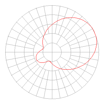
| Antenna Data for Antenna Id: 1006357 WATM-TV DT File: -0000105303 DIELECTRIC - TFU-16ETT/VP-R S300 Service: DT Standard Pattern: N |  | ||||||||||||||||||||||||
| Azimuth | Ratio | Azimuth | Ratio | Azimuth | Ratio | Azimuth | Ratio | ||||||||||||||||||
| 0 | 0.586 | 10 | 0.674 | 20 | 0.764 | 30 | 0.850 | ||||||||||||||||||
| 40 | 0.923 | 50 | 0.975 | 60 | 1.000 | 70 | 0.997 | ||||||||||||||||||
| 80 | 0.967 | 90 | 0.910 | 100 | 0.834 | 110 | 0.747 | ||||||||||||||||||
| 120 | 0.656 | 130 | 0.569 | 140 | 0.488 | 150 | 0.419 | ||||||||||||||||||
| 160 | 0.356 | 170 | 0.298 | 180 | 0.248 | 190 | 0.211 | ||||||||||||||||||
| 200 | 0.208 | 210 | 0.243 | 220 | 0.295 | 230 | 0.341 | ||||||||||||||||||
| 240 | 0.366 | 250 | 0.364 | 260 | 0.334 | 270 | 0.284 | ||||||||||||||||||
| 280 | 0.234 | 290 | 0.205 | 300 | 0.216 | 310 | 0.257 | ||||||||||||||||||
| 320 | 0.310 | 330 | 0.368 | 340 | 0.432 | 350 | 0.505 | ||||||||||||||||||
Structure Registration Number 1027125 Structure Type: TOWER Registered To: Johnstown (WWCP-TV), Inc. Structure Address: Rd 1 Box 190 B Dysart, PA County Name: Blair County ASR Issued: 02/16/2022 Date Built: 10/01/1986 Site Elevation: 771.1 m (2530 ft.) Structure Height: 73.2 m (240 ft.) Height Overall: 84.4 m (277 ft.) Overall Height AMSL: 855.5 m (2807 ft.) FAA Determination: 09/22/1986 FAA Study #: 86-AEA-1608-OE FAA Circular #: 70/7460-1G Paint & Light FAA Chapters: 3, 4, 5, 9 RED LIGHTS/PAINT 40-34-06.0 N 78-26-37.0 W (NAD 83) 40-34-05.8 N 78-26-37.9 W (Converted to NAD 27) |
90 Lulay Street, Suite 1 Johnstown, PA 15904 Phone: 814-269-1141 Limited Partnership | Title: President GF Inc. General Partner of Licensee Date: 02/04/2020 Application Certifier Palm Television, L.P. Palm Television, L.P. 1450 Scalp Avenue Johnstown, PA 15904 Applicant John E Hidle, P.E Carl T. Jones Corporation 7901 Yarnwood Court Springfield, VA 22153-2827 Consulting Engineer Paul A. Cicelski, Esq Lerman Senter PLLC 2001 L St. NW Suite 400 Washington, MD 20036 Nathaniel Hardy Marashlian & Donahue, PLLC - the Commlaw Group 1420 Spring Hill Road Suite 401 McLean, VA 22102 Jill L. Ream Palm Television, LP 1450 Scalp Avenue Johnstown, PA 15904 General Manager | |||||||||||||||||||||||
| |||||||||||||||||||||||||