FCCInfo.com
A Service of Cavell, Mertz & Associates, Inc.
(855) FCC-INFO
|
|
WXNE-TV from 02/28/1979 WXNE from ??? |
Virtual Channel 25 |  |
|
||||||||||||||||||||||||||||||
|
|
Status: LIC Application Accepted: 08/16/2019 License Expires: 04/01/2031 File Number: 0000080415 FCC Website Links: LMS Facility Details This Application Other WFXT Applications Including Superseded Applications Service Contour - Open Street Map or USGS Map (41 dBu) Service Contour - KML / Google Earth (41 dBu) Public Inspection Files Rabbit Ears Info Search for WFXT Site Location: 42-18-37.0 N 71-14-12.0 W (NAD 83) Site Location: 42-18-36.6 N 71-14-13.8 W (Converted to NAD 27) ERP: 390 kW Polarization: Horizontally polarized HAAT: 336 m (1102 ft.) Electrical Beam Tilt: 0.5 degrees R/C AGL: 329.6 m (1081 ft.) R/C AMSL: 376.2 m (1234 ft.) Site Elevation: 46.6 m. (153 ft.) Height Overall*: 395.1 m (1296 ft.) (* As Filed In This Application, may differ from ASR Data, Below.) Directional Antenna - Antenna Make/Model: DIELECTRIC TFU-24WB C160 Antenna ID: 1005417 Polarization: Horizontally polarized | |||||||||||||||||||||||||||||||||
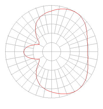
| Antenna Data for Antenna Id: 1005417 WFXT DX File: -0000080415 DIELECTRIC - TFU-24WB C160 Service: DX Standard Pattern: N Pattern and Field Values Include a 89.5° Clockwise Rotation |  | |||||||||||||||||||||||||||||||||
| Azimuth | Ratio | Azimuth | Ratio | Azimuth | Ratio | Azimuth | Ratio | |||||||||||||||||||||||||||
| 0 | 0.874 | 9 | 0.922 | 19 | 0.966 | 29 | 0.992 | |||||||||||||||||||||||||||
| 32 | 0.994 | 39 | 0.986 | 49 | 0.945 | 59 | 0.884 | |||||||||||||||||||||||||||
| 69 | 0.826 | 79 | 0.790 | 89 | 0.779 | 99 | 0.791 | |||||||||||||||||||||||||||
| 109 | 0.829 | 119 | 0.888 | 129 | 0.950 | 139 | 0.991 | |||||||||||||||||||||||||||
| 146 | 1.000 | 149 | 0.998 | 159 | 0.971 | 169 | 0.924 | |||||||||||||||||||||||||||
| 179 | 0.874 | 189 | 0.824 | 199 | 0.759 | 209 | 0.659 | |||||||||||||||||||||||||||
| 219 | 0.517 | 229 | 0.367 | 236 | 0.317 | 239 | 0.322 | |||||||||||||||||||||||||||
| 249 | 0.429 | 259 | 0.551 | 269 | 0.599 | 279 | 0.551 | |||||||||||||||||||||||||||
| 289 | 0.429 | 299 | 0.320 | 301 | 0.314 | 309 | 0.364 | |||||||||||||||||||||||||||
| 319 | 0.515 | 329 | 0.660 | 339 | 0.761 | 349 | 0.825 | |||||||||||||||||||||||||||
Structure Registration Number 1003433 Structure Type: GTOWER Registered To: American Towers LLC Structure Address: 350 Cedar Street (282685) Needham Heights, MA County Name: Norfolk County ASR Issued: 04/07/2023 Date Built: 01/01/1957 Site Elevation: 46.6 m (153 ft.) Structure Height: 363.4 m (1192 ft.) Height Overall: 395.1 m (1296 ft.) Overall Height AMSL: 441.7 m (1449 ft.) FAA Determination: 02/08/2023 FAA Study #: 2022-ANE-1323-OE FAA Circular #: 70/7460-1L Paint & Light FAA Chapters: 3, 4, 5, 12 PRIOR STUDY 2016-ANE-1795-OE 42-18-37.2 N 71-14-11.7 W (NAD 83) 42-18-36.8 N 71-14-13.5 W (Converted to NAD 27) |
1601 W. Peachtree Street, NE Atlanta, GA 30309 Phone: 404-897-7000 Limited Liability Company | Title: Vice President and General Manager Date: 08/16/2019 Application Certifier Cox Media Group Northeast, LLC Cox Media Group Northeast, LLC 25 Fox Drive Dedham, MA 02026 Applicant Sean Anker WFXT(TV) 25 Fox Drive Dedham, MA 02026 Chief Engineer Christina Burrow Cooley LLP 1299 Pennsylvania Avenue, NW Suite 700 Washington, DC 20004 Legal Representative S Merrill Weiss Merrill Weiss Group LLC 227 Central Ave Metuchen, NJ 08840 Technical Consultant | ||||||||||||||||||||||||||||||||
|
| |||||||||||||||||||||||||||||||||