FCCInfo.com
A Service of Cavell, Mertz & Associates, Inc.
(855) FCC-INFO
|
|
870602KG from ??? |
Virtual Channel 22 |
|
|||||||||||||||||||
|
|
Status: LIC Application Accepted: 09/16/2019 License Expires: 04/01/2029 File Number: 0000081490 FCC Website Links: LMS Facility Details This Application Other WBMM Applications Including Superseded Applications Service Contour - Open Street Map or USGS Map (41 dBu) Service Contour - KML / Google Earth (41 dBu) Public Inspection Files Rabbit Ears Info Search for WBMM Site Location: 32-04-05.5 N 85-56-40.8 W (NAD 83) Site Location: 32-04-05.0 N 85-56-41.0 W (Converted to NAD 27) ERP: 52 kW Polarization: Horizontally polarized HAAT: 337 m (1106 ft.) Electrical Beam Tilt: 1 degree R/C AGL: 287 m (942 ft.) R/C AMSL: 463.8 m (1522 ft.) Site Elevation: 176.8 m. (580 ft.) Height Overall*: 298.7 m (980 ft.) (* As Filed In This Application, may differ from ASR Data, Below.) Directional Antenna - Antenna Make/Model: DIELECTRIC TLP-12C Antenna ID: 1005555 Polarization: Horizontally polarized | |||||||||||||||||||||
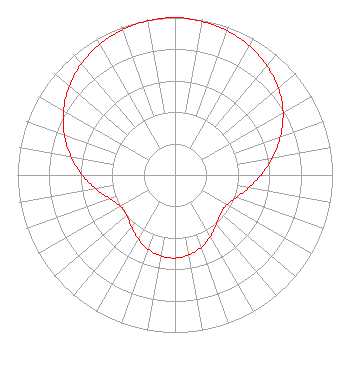
| Antenna Data for Antenna Id: 1005555 WBMM DT File: -0000081490 DIELECTRIC - TLP-12C Service: DT Standard Pattern: N |  | |||||||||||||||||||||
| Azimuth | Ratio | Azimuth | Ratio | Azimuth | Ratio | Azimuth | Ratio | |||||||||||||||
| 0 | 1.000 | 10 | 0.990 | 20 | 0.973 | 30 | 0.946 | |||||||||||||||
| 40 | 0.907 | 50 | 0.857 | 60 | 0.792 | 70 | 0.713 | |||||||||||||||
| 80 | 0.628 | 90 | 0.547 | 100 | 0.474 | 110 | 0.414 | |||||||||||||||
| 120 | 0.378 | 130 | 0.378 | 140 | 0.408 | 150 | 0.449 | |||||||||||||||
| 160 | 0.487 | 170 | 0.515 | 180 | 0.527 | 190 | 0.522 | |||||||||||||||
| 200 | 0.500 | 210 | 0.467 | 220 | 0.430 | 230 | 0.400 | |||||||||||||||
| 240 | 0.398 | 250 | 0.440 | 260 | 0.510 | 270 | 0.590 | |||||||||||||||
| 280 | 0.671 | 290 | 0.748 | 300 | 0.818 | 310 | 0.877 | |||||||||||||||
| 320 | 0.924 | 330 | 0.958 | 340 | 0.980 | 350 | 0.994 | |||||||||||||||
Structure Registration Number 1200186 Structure Type: GTOWER Registered To: Alabama Telecasters, Inc. Structure Address: Near Intersection Of Cr37 And Old Pike Rd Tuskeegee, AL County Name: Bullock County ASR Issued: 01/07/2020 Date Built: 06/05/2002 Site Elevation: 176.8 m (580 ft.) Structure Height: 297.7 m (977 ft.) Height Overall: 298.7 m (980 ft.) Overall Height AMSL: 475.5 m (1560 ft.) FAA Determination: 10/16/2019 FAA Study #: 2019-ASO-27447-OE FAA Circular #: 70/7460-1J Paint & Light FAA Chapters: 3, 4, 5, 13 OM&L to remain the same as prior study = PAINT/RED LIGHTS 32-04-05.5 N 85-56-40.8 W (NAD 83) 32-04-05.0 N 85-56-41.0 W (Converted to NAD 27) |
C/O Russell Schwartz One Television Place Charlotte, NC 28205 Phone: 704-372-4434 General Partnership | Title: President of Managing Partner of Alabama Broadcasting Partners Date: 09/16/2019 Application Certifier Alabama Broadcasting Partners Alabama Broadcasting Partners One Television Place Charlotte, NC 28205 Applicant Louis R Dutreil, Jr Dutreil Lundin & Rackley Inc 3135 Southgate Circle Sarasota, FL 34239 Technical Consultant M. Anne Swanson Wilkinson Barker Knauer LLP 1800 M Street NW Washington, DC 20036 Legal Counsel | ||||||||||||||||||||
| ||||||||||||||||||||||