FCCInfo.com
A Service of Cavell, Mertz & Associates, Inc.
(855) FCC-INFO
|
|
WHYN-TV from 03/28/1980 WGGB-TV from 12/31/1979 WHYN from ??? |
Virtual Channel 40 |  |
|
|||||||||||||||||||||||||||||||||
|
|
Status: LIC Application Accepted: 10/02/2019 License Expires: 04/01/2031 File Number: 0000083684 FCC Website Links: LMS Facility Details This Application Other WGGB-TV Applications Including Superseded Applications Service Contour - Open Street Map or USGS Map (41 dBu) Service Contour - KML / Google Earth (41 dBu) Public Inspection Files Rabbit Ears Info Search for WGGB-TV Site Location: 42-14-30.0 N 72-38-55.0 W (NAD 83) Site Location: 42-14-29.7 N 72-38-56.7 W (Converted to NAD 27) ERP: 345 kW Polarization: Elliptically polarized HAAT: 320 m (1050 ft.) Electrical Beam Tilt: 0.75 degrees R/C AGL: 53 m (174 ft.) R/C AMSL: 418.8 m (1374 ft.) Site Elevation: 365.8 m. (1200 ft.) Height Overall*: 59.6 m (196 ft.) (* As Filed In This Application, may differ from ASR Data, Below.) Directional Antenna - Antenna Make/Model: DIELECTRIC TFU-20ETT/VP-R S210 Antenna ID: 1001267 Polarization: Elliptically polarized | ||||||||||||||||||||||||||||||||||||
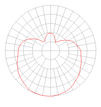
| Antenna Data for Antenna Id: 1001267 WGGB-TV DT File: -0000083684 DIELECTRIC - TFU-20ETT/VP-R S210 Service: DT Standard Pattern: Y |  | ||||||||||||||||||||||||||||||||||||
| Azimuth | Ratio | Azimuth | Ratio | Azimuth | Ratio | Azimuth | Ratio | ||||||||||||||||||||||||||||||
| 0 | 0.380 | 10 | 0.360 | 20 | 0.280 | 30 | 0.220 | ||||||||||||||||||||||||||||||
| 40 | 0.260 | 50 | 0.350 | 60 | 0.450 | 70 | 0.540 | ||||||||||||||||||||||||||||||
| 80 | 0.600 | 90 | 0.660 | 100 | 0.680 | 110 | 0.720 | ||||||||||||||||||||||||||||||
| 120 | 0.760 | 130 | 0.820 | 140 | 0.860 | 150 | 0.920 | ||||||||||||||||||||||||||||||
| 160 | 0.960 | 170 | 0.980 | 180 | 1.000 | 190 | 1.000 | ||||||||||||||||||||||||||||||
| 200 | 0.990 | 210 | 0.970 | 220 | 0.920 | 230 | 0.880 | ||||||||||||||||||||||||||||||
| 240 | 0.830 | 250 | 0.780 | 260 | 0.730 | 270 | 0.710 | ||||||||||||||||||||||||||||||
| 280 | 0.680 | 290 | 0.620 | 300 | 0.510 | 310 | 0.390 | ||||||||||||||||||||||||||||||
| 320 | 0.260 | 330 | 0.250 | 340 | 0.310 | 350 | 0.370 | ||||||||||||||||||||||||||||||
Structure Registration Number 1018460 Structure Type: TOWER Registered To: SBA Infrastructures, LLC Structure Address: Atop Mount Tom Holyoke, MA County Name: Hampden County ASR Issued: 09/22/2008 Date Built: 09/01/1987 Site Elevation: 365.8 m (1200 ft.) Structure Height: 45.7 m (150 ft.) Height Overall: 59.6 m (196 ft.) Overall Height AMSL: 425.4 m (1396 ft.) FAA Determination: 02/21/1997 FAA Study #: 96-ANE-0559-OE Paint & Light FAA Chapters: NONE Removed expiration date from determination. Scenario 1./jjs/case#635066 42-14-30.0 N 72-38-55.0 W (NAD 83) 42-14-29.7 N 72-38-56.7 W (Converted to NAD 27) |
4370 Peachtree Road, NE Atlanta, GA 30319 Phone: 404-504-9828 Limited Liability Company | Title: President, Local Media Group Date: 10/02/2019 Application Certifier Meredith Corporation Meredith Corporation 1716 Locust Street Des Moines, IA 50309 Applicant Christina H Burrow Cooley LLLP 1299 Pennsylvania Avenue, NW Suite 700 Washington, DC 20004 Legal Counsel Louis R Dutreil, Jr Dutreil Lundin & Rackley Inc 3135 Southgate Circle Sarasota, FL 34239 Technical Consultant Larence Oaks Meredith Corporation 8668 Highwood Indianapolis, IN 46278 Repack Manager Technology Meredith Corp Joshua N. Pila Meredith Corporation 425 14th Street NW Atlanta, GA 30318 General Counsel | |||||||||||||||||||||||||||||||||||
|
| ||||||||||||||||||||||||||||||||||||