FCCInfo.com
A Service of Cavell, Mertz & Associates, Inc.
(855) FCC-INFO
|
|
W33BY-D from 01/29/2015 W33BY from 10/11/2002 W68CH from 06/03/1999 W33BY from 06/02/1999 W68CH from 06/02/1999 DW68CH from 03/12/1996 W68CH from 08/31/1990 891208M9 from ??? |
|
|
||||||||||||||||
|
|
Status: LIC Application Accepted: 09/23/2019 License Expires: 10/01/2029 File Number: 0000081938 FCC Website Links: LMS Facility Details This Application Other WHPS-CD Applications Including Superseded Applications Service Contour - Open Street Map or USGS Map (51 dBu) Service Contour - KML / Google Earth (51 dBu) Public Inspection Files Rabbit Ears Info Search for WHPS-CD Site Location: 42-24-22.0 N 83-06-44.0 W (NAD 83) Site Location: 42-24-21.9 N 83-06-44.3 W (Converted to NAD 27) ERP: 15 kW Polarization: Horizontally polarized Electrical Beam Tilt: 0.5 degrees R/C AGL: 120.4 m (395 ft.) R/C AMSL: 314.9 m (1033 ft.) Emission Mask: Full Service Site Elevation: 194.5 m. (638 ft.) Height Overall*: 152.1 m (499 ft.) (* As Filed In This Application, may differ from ASR Data, Below.) Directional Antenna - Antenna Make/Model: Electronics Research Inc. ALP16L2-HSW Antenna ID: 1004062 Polarization: Horizontally polarized | ||||||||||||||||||
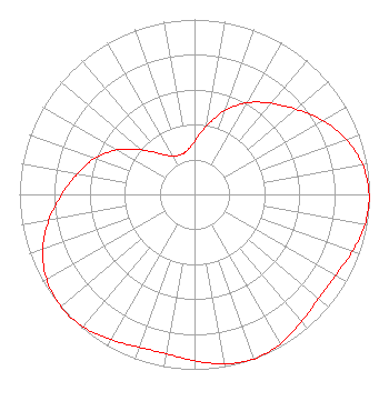
| Antenna Data for Antenna Id: 1004062 WHPS-CD DC File: -0000081938 Electronics Research Inc. - ALP16L2-HSW Service: DC Standard Pattern: N |  | ||||||||||||||||||
| Azimuth | Ratio | Azimuth | Ratio | Azimuth | Ratio | Azimuth | Ratio | ||||||||||||
| 0 | 0.302 | 10 | 0.397 | 20 | 0.510 | 30 | 0.605 | ||||||||||||
| 40 | 0.680 | 50 | 0.758 | 60 | 0.845 | 70 | 0.922 | ||||||||||||
| 80 | 0.975 | 90 | 0.997 | 100 | 0.990 | 110 | 0.959 | ||||||||||||
| 120 | 0.929 | 130 | 0.925 | 140 | 0.951 | 150 | 0.985 | ||||||||||||
| 160 | 1.000 | 170 | 0.985 | 180 | 0.951 | 190 | 0.925 | ||||||||||||
| 200 | 0.929 | 210 | 0.959 | 220 | 0.990 | 230 | 0.997 | ||||||||||||
| 240 | 0.975 | 250 | 0.922 | 260 | 0.845 | 270 | 0.758 | ||||||||||||
| 280 | 0.680 | 290 | 0.605 | 300 | 0.510 | 310 | 0.397 | ||||||||||||
| 320 | 0.302 | 330 | 0.253 | 340 | 0.241 | 350 | 0.253 | ||||||||||||
Structure Registration Number 1040469 Structure Type: LTOWER Registered To: Vertical Bridge CC FM, LLC Structure Address: 375 Midland Ave Higland Park, MI County Name: Wayne County ASR Issued: 11/08/2018 Date Built: 01/01/1981 Site Elevation: 194.5 m (638 ft.) Structure Height: 151.5 m (497 ft.) Height Overall: 152.1 m (499 ft.) Overall Height AMSL: 346.6 m (1137 ft.) FAA Determination: 10/30/1980 FAA Study #: 80-GL-1430-OE FAA Circular #: 70/7460-1 Paint & Light FAA Chapters: 1, 3, 4, 13, 21 RED LIGHTS/PAINT 42-24-22.0 N 83-06-44.0 W (NAD 83) 42-24-21.9 N 83-06-44.3 W (Converted to NAD 27) |
121 S. Orange Ave. Suite 1500 Orlando, FL 32801 Phone: 561-578-4845 Limited Liability Company | Title: Manager Date: 09/23/2019 Application Certifier HME Equity Fund II, LLC HME Equity Fund II, LLC 121 S. Orange Avenue Suite 1500 Orlando, FL 32801 Applicant Dean Goodman HME Equity Fund II, LLC 319 Clematis St. #210 West Palm Beach, FL 33480 General Manager - Station Operations Davina Sashkin, Esq Fletcher, Heald & Hildreth, PLC 1300 N 17th Street 11th Floor Arlington, VA 22209 Partner | |||||||||||||||||