FCCInfo.com
A Service of Cavell, Mertz & Associates, Inc.
(855) FCC-INFO
|
|
K27JJ-D from 08/13/2007 |
|
|
||||||||||||||||
|
|
Status: LIC Application Accepted: 10/29/2019 License Expires: 08/01/2022 File Number: 0000087596 FCC Website Links: LMS Facility Details This Application Other DK27JJ-D Applications Including Superseded Applications Service Contour - Open Street Map or USGS Map (51 dBu) Service Contour - KML / Google Earth (51 dBu) Rabbit Ears Info Search for DK27JJ-D Site Location: 30-33-10.7 N 94-24-31.7 W (NAD 83) Site Location: 30-33-10.0 N 94-24-31.0 W (Converted to NAD 27) ERP: 7.6 kW Electrical Beam Tilt: 1.75 degrees R/C AGL: 134.4 m (441 ft.) R/C AMSL: 173.4 m (569 ft.) Emission Mask: Stringent Site Elevation: 39 m. (128 ft.) Height Overall*: 152.1 m (499 ft.) (* As Filed In This Application, may differ from ASR Data, Below.) Directional Antenna - Antenna Make/Model: Andrew AL8W Antenna ID: 16357 | ||||||||||||||||||
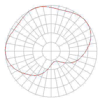
| Antenna Data for Antenna Id: 16357 DK27JJ-D LD File: -0000087596 Andrew - AL8W Service: LD Standard Pattern: Y Pattern and Field Values Include a 340° Clockwise Rotation |  | ||||||||||||||||||
| Azimuth | Ratio | Azimuth | Ratio | Azimuth | Ratio | Azimuth | Ratio | ||||||||||||
| 0 | 0.951 | 10 | 0.925 | 20 | 0.929 | 30 | 0.959 | ||||||||||||
| 40 | 0.990 | 50 | 0.997 | 60 | 0.975 | 70 | 0.922 | ||||||||||||
| 80 | 0.845 | 90 | 0.758 | 100 | 0.680 | 110 | 0.605 | ||||||||||||
| 120 | 0.510 | 130 | 0.397 | 140 | 0.302 | 150 | 0.253 | ||||||||||||
| 160 | 0.241 | 170 | 0.253 | 180 | 0.302 | 190 | 0.397 | ||||||||||||
| 200 | 0.510 | 210 | 0.605 | 220 | 0.680 | 230 | 0.758 | ||||||||||||
| 240 | 0.845 | 250 | 0.922 | 260 | 0.975 | 270 | 0.997 | ||||||||||||
| 280 | 0.990 | 290 | 0.959 | 300 | 0.929 | 310 | 0.925 | ||||||||||||
| 320 | 0.951 | 330 | 0.985 | 340 | 1.000 | 350 | 0.985 | ||||||||||||
Structure Registration Number 1008747 Structure Type: GTOWER Registered To: Crown Castle GT Company LLC Structure Address: 183 Cr 1910 Warren, TX County Name: Tyler County ASR Issued: 05/06/2016 Date Built: 05/06/2014 Site Elevation: 39 m (128 ft.) Structure Height: 146.3 m (480 ft.) Height Overall: 152.1 m (499 ft.) Overall Height AMSL: 191.1 m (627 ft.) FAA Determination: 03/19/2014 FAA Study #: 2014-ASW-1905-OE FAA Circular #: 70/7460-1K Paint & Light FAA Chapters: 4, 6, 12 PRIOR STUDY 2010-ASW-6930-OE 30-33-10.7 N 94-24-31.7 W (NAD 83) 30-33-10.0 N 94-24-31.0 W (Converted to NAD 27) |
Tegna, Inc. 8350 Broad Street, Suite 2000 Tysons, VA 22102 Phone: 703-873-6606 Corporation | Title: Secretary Date: 10/29/2019 Application Certifier LSB Broadcasting, Inc. Tegna, Inc. 8350 Broad Street, Suite 2000 Tysons, VA 22102 Applicant Michael Beder, Esq Tegna Inc. 8350 Broad Street, Suite 2000 Tysons, VA 22102 Associate General Counsel Ryan C Wilhour Kessler and Gehman Associates, Inc. 507 NW 60th St Suite C Gainesville, FL 32607 Consulting Engineer | |||||||||||||||||