FCCInfo.com
A Service of Cavell, Mertz & Associates, Inc.
(855) FCC-INFO
|
|
WSRE-TV from 01/23/1979 WSRE from ??? |
Virtual Channel 23 |
|
|||||||||||||||||||
|
|
Status: LIC Application Accepted: 11/22/2019 License Expires: 02/01/2029 File Number: 0000090765 FCC Website Links: LMS Facility Details This Application Other WSRE Applications Including Superseded Applications Service Contour - Open Street Map or USGS Map (41 dBu) Service Contour - KML / Google Earth (41 dBu) Public Inspection Files Rabbit Ears Info Search for WSRE Site Location: 30-36-41.0 N 87-36-26.4 W (NAD 83) Site Location: 30-36-40.3 N 87-36-26.5 W (Converted to NAD 27) ERP: 859 kW Polarization: Horizontally polarized HAAT: 551.6 m (1810 ft.) Electrical Beam Tilt: 1.00 degree R/C AGL: 555.6 m (1823 ft.) R/C AMSL: 587.9 m (1929 ft.) Site Elevation: 32.3 m. (106 ft.) Height Overall*: 577.3 m (1894 ft.) (* As Filed In This Application, may differ from ASR Data, Below.) Directional Antenna - Antenna Make/Model: Electronics Research, Inc ATW17H4-ETC5-24H Antenna ID: 1005989 Polarization: Horizontally polarized | |||||||||||||||||||||
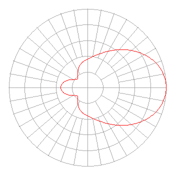
| Antenna Data for Antenna Id: 1005989 WSRE DT File: -0000090765 Electronics Research, Inc - ATW17H4-ETC5-24H Service: DT Standard Pattern: N |  | |||||||||||||||||||||
| Azimuth | Ratio | Azimuth | Ratio | Azimuth | Ratio | Azimuth | Ratio | |||||||||||||||
| 0 | 0.361 | 10 | 0.400 | 20 | 0.455 | 30 | 0.532 | |||||||||||||||
| 40 | 0.627 | 50 | 0.732 | 60 | 0.834 | 70 | 0.921 | |||||||||||||||
| 80 | 0.979 | 90 | 1.000 | 100 | 0.979 | 110 | 0.921 | |||||||||||||||
| 120 | 0.834 | 130 | 0.732 | 140 | 0.627 | 150 | 0.532 | |||||||||||||||
| 160 | 0.455 | 170 | 0.400 | 180 | 0.361 | 190 | 0.330 | |||||||||||||||
| 200 | 0.292 | 210 | 0.243 | 220 | 0.190 | 230 | 0.166 | |||||||||||||||
| 240 | 0.202 | 250 | 0.267 | 260 | 0.320 | 270 | 0.339 | |||||||||||||||
| 280 | 0.320 | 290 | 0.267 | 300 | 0.202 | 310 | 0.166 | |||||||||||||||
| 320 | 0.190 | 330 | 0.243 | 340 | 0.292 | 350 | 0.330 | |||||||||||||||
Structure Registration Number 1064671 Structure Type: GTOWER Registered To: American Towers, LLC Structure Address: 26567 Ernest Patterson Rd (#300182) Robertsdale, AL County Name: Baldwin County ASR Issued: 02/07/2020 Date Built: 04/06/2001 Site Elevation: 32.3 m (106 ft.) Structure Height: 550 m (1804 ft.) Height Overall: 577.3 m (1894 ft.) Overall Height AMSL: 609.6 m (2000 ft.) FAA Determination: 09/19/2008 FAA Study #: 2008-ASO-4938-OE FAA Circular #: 70/7460-1K Paint & Light FAA Chapters: 4, 9, 12 OM&L to remain the same as prior study = A HIGH-DUAL SYSTEM 30-36-41.0 N 87-36-26.4 W (NAD 83) 30-36-40.3 N 87-36-26.5 W (Converted to NAD 27)  American Tower Corporation 300182 - Mobile AL 2 |
1000 College Blvd Pensacola, FL 32504 Phone: 850-484-1700 Government Entity | Title: President Date: 11/22/2019 Application Certifier The District Board of Trustees, Pensacola State College, FL. The District Board of Trustees, Pensacola State College, FL. 1000 College Blvd Pensacola, FL 32504 Applicant William T Godfrey, Jr Kessler and Gehman Associates, Inc. Kessler and Gehman Associates, Inc. 507-D NW 60th Street Gainesville, FL 32607 Consulting Engineers Barry S. Persh Gray Miller Persh LLP 2233 Wisconsin Ave., NW Suite 226 Washington, DC 20007 Ryan C Wilhour Kessler and Gehman Associates, Inc. 507 NW 60th St Ste D Gainesville, FL 32607 Consulting Engineer | ||||||||||||||||||||
| ||||||||||||||||||||||