FCCInfo.com
A Service of Cavell, Mertz & Associates, Inc.
(855) FCC-INFO
|
|
W44CR-D from 11/03/2009 W58AM from 05/27/1980 790710IC from ??? |
|
|
||||||||||||||||
|
|
Status: LIC Application Accepted: 11/21/2019 License Expires: 10/01/2029 File Number: 0000090576 FCC Website Links: LMS Facility Details This Application Other W13DP-D Applications Including Superseded Applications Service Contour - Open Street Map or USGS Map (48 dBu) Service Contour - KML / Google Earth (48 dBu) Rabbit Ears Info Search for W13DP-D Site Location: 41-04-48.6 N 80-38-24.4 W (NAD 83) Site Location: 41-04-48.4 N 80-38-25.1 W (Converted to NAD 27) ERP: 0.27 kW Polarization: Elliptically polarized R/C AGL: 195 m (640 ft.) R/C AMSL: 509.9 m (1673 ft.) Emission Mask: Full Service Site Elevation: 314.9 m. (1033 ft.) Height Overall*: 311.2 m (1021 ft.) (* As Filed In This Application, may differ from ASR Data, Below.) Directional Antenna - Antenna Make/Model: Jampro JSL-2/13-SEO-V Antenna ID: 1005977 Polarization: Elliptically polarized | ||||||||||||||||||
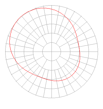
| Antenna Data for Antenna Id: 1005977 W13DP-D LD File: -0000090576 Jampro - JSL-2/13-SEO-V Service: LD Standard Pattern: N Pattern and Field Values Include a 320° Clockwise Rotation |  | ||||||||||||||||||
| Azimuth | Ratio | Azimuth | Ratio | Azimuth | Ratio | Azimuth | Ratio | ||||||||||||
| 0 | 0.915 | 10 | 0.871 | 20 | 0.820 | 30 | 0.767 | ||||||||||||
| 40 | 0.715 | 50 | 0.668 | 60 | 0.631 | 70 | 0.609 | ||||||||||||
| 80 | 0.602 | 90 | 0.608 | 100 | 0.623 | 110 | 0.642 | ||||||||||||
| 120 | 0.659 | 130 | 0.672 | 140 | 0.676 | 150 | 0.672 | ||||||||||||
| 160 | 0.659 | 170 | 0.642 | 180 | 0.623 | 190 | 0.608 | ||||||||||||
| 200 | 0.602 | 210 | 0.609 | 220 | 0.631 | 230 | 0.668 | ||||||||||||
| 240 | 0.715 | 250 | 0.767 | 260 | 0.820 | 270 | 0.871 | ||||||||||||
| 280 | 0.915 | 290 | 0.951 | 300 | 0.978 | 310 | 0.994 | ||||||||||||
| 320 | 1.000 | 330 | 0.994 | 340 | 0.978 | 350 | 0.951 | ||||||||||||
Structure Registration Number 1015316 Structure Type: GTOWER Registered To: WFMJ TELEVISION INC DBA = WFMJ Structure Address: 750 Mabel St Youngstown, OH County Name: Mahoning County ASR Issued: 09/18/2013 Date Built: 12/03/2013 Site Elevation: 314.9 m (1033 ft.) Structure Height: 292 m (958 ft.) Height Overall: 311.2 m (1021 ft.) Overall Height AMSL: 626.1 m (2054 ft.) FAA Determination: 09/10/2013 FAA Study #: 2013-AGL-8829-OE Paint & Light FAA Chapters: 1, 3, 7, 16, 21 PRIOR STUDY 2006-AGL-3581-OE OM&l PAINT/RED LIGHTS (FCC PARAGRAPHS) ADD SPECIAL CONDITION FOR LIGHTING DEVIATION. 41-04-48.6 N 80-38-24.4 W (NAD 83) 41-04-48.4 N 80-38-25.1 W (Converted to NAD 27) |
1750 W. Campus Center Drive Kent, OH 44240 Phone: 330-677-4549 Not-for-Profit | Title: President and Ceo Date: 11/21/2019 Application Certifier Northeastern Educational Television of Ohio, Inc. Northeastern Educational Television of Ohio, Inc. 1750 Campus Center Drive P.O. Box 5191 Kent, OH 44240 Applicant Anthony Dennis Northeastern Educational television of Ohio, Inc. 1750 Campus Center Dr PO Box 5191 Kent, OH 44240 Operations Manager Barry S. Persh Gray Miller Persh LLP 2233 Wisconsin Ave., NW Suite 226 Washington, DC 20007 Ryan C Wilhour Kessler and Gehman Associates, Inc. 507 NW 60th St Ste D Gainesville, FL 32607 Consulting Engineer | |||||||||||||||||