FCCInfo.com
A Service of Cavell, Mertz & Associates, Inc.
(855) FCC-INFO
|
|
|
|
|
||||||||||||||||
|
|
W293AU Channel: 293D 106.5 MHz Derby, Connecticut Service: FX - A translator or application for a translator. Facility ID: 143438 FRN: 0004888772 Fac. Service: FX Programming Delivery Method: Unspecified Status: LIC Application Accepted: 12/05/2019 Application Granted: 12/11/2019 File Number: 0000092765 License Expires: 04/01/2030 Application Type: License To Cover FCC Website Links: LMS Facility Details This Application Other W293AU Applications Including Superseded Applications Service Contour - Open Street Map or USGS Map (60 dBu) Service Contour - KML / Google Earth (60 dBu) Facility Type: NON-COMMERCIAL EDUC. FM Class: D, A Noncommercial educational operating with no more than 10W Site Location: 41-23-29.5 N 73-03-12.0 W (NAD 83) Site Location: 41-23-29.2 N 73-03-13.6 W (Converted to NAD 27) Effective Radiated Power: 0 kW Horiz. ; 0.25 kW Vert. Transmitter Output Power: 0.094 kW Antenna Center AMSL: 0 m Horiz.; 231 m Vert. Antenna Center HAG: 0 m Horiz.; 85 m Vert. Site Elevation: 146 m. (479 ft.) Height Overall*: 88 m (289 ft.) (* As Filed In This Application, may differ from ASR Data, Below.) Directional Antenna Antenna Make/Model: Nicom V-Pol 4 bay Antenna ID: 135398 Polarization: H
| ||||||||||||||||||
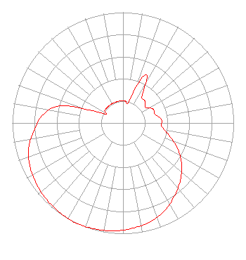
| Antenna Data for Antenna Id: 135398 W293AU FX File: -0000092765 Nicom - V-Pol 4 bay Service: FX Pattern and Field Values Include a 205° Clockwise Rotation |  | ||||||||||||||||||
| Azimuth | Ratio | Azimuth | Ratio | Azimuth | Ratio | Azimuth | Ratio | ||||||||||||
| 5 | 0.200 | 15 | 0.200 | 25 | 0.480 | 35 | 0.300 | ||||||||||||
| 45 | 0.280 | 55 | 0.248 | 65 | 0.300 | 75 | 0.300 | ||||||||||||
| 85 | 0.350 | 95 | 0.350 | 105 | 0.430 | 115 | 0.543 | ||||||||||||
| 125 | 0.646 | 135 | 0.733 | 145 | 0.808 | 155 | 0.882 | ||||||||||||
| 165 | 0.927 | 175 | 0.956 | 185 | 0.978 | 195 | 0.990 | ||||||||||||
| 205 | 1.000 | 215 | 0.990 | 225 | 0.978 | 235 | 0.956 | ||||||||||||
| 245 | 0.927 | 255 | 0.882 | 265 | 0.808 | 275 | 0.733 | ||||||||||||
| 285 | 0.590 | 295 | 0.200 | 305 | 0.200 | 315 | 0.200 | ||||||||||||
| 325 | 0.200 | 335 | 0.200 | 345 | 0.200 | 355 | 0.200 | ||||||||||||
Structure Registration Number 1209826 Structure Type: TOWER Registered To: EMAC Communications Company Inc Structure Address: Intersection Progress Ln. & Silvermine Road Seymour, CT County Name: New Haven County ASR Issued: 02/23/2000 Site Elevation: 146 m (479 ft.) Structure Height: 87.8 m (288 ft.) Height Overall: 87.8 m (288 ft.) Overall Height AMSL: 233.8 m (767 ft.) FAA Determination: 12/30/1999 FAA Study #: 99-ANE-0600-OE FAA Circular #: 70/7460-1J Paint & Light FAA Chapters: 4, 6, 13 SUPPLEMENTAL NOTICE STATES STRUCTURE REACHED GREATEST HEIGHT ON 8-29-00 41-23-29.5 N 73-03-12.0 W (NAD 83) 41-23-29.2 N 73-03-13.6 W (Converted to NAD 27) |
5151 Park Ave Fairfield, CT 06825-1023 Phone: 203-371-7989 Corporation | Title: President Date: 12/05/2019 Application Certifier Sacred Heart University, Inc. Sacred Heart University, Inc. 5151 Park Ave Fairfield, CT 06825 Applicant Mark Lipp Fletcher Heald & Hildreth PLC 1300 N 17th Street Arlington, VA 22209 Attorney | |||||||||||||||||