FCCInfo.com
A Service of Cavell, Mertz & Associates, Inc.
(855) FCC-INFO
|
|
KNIC-CD from 06/03/2015 KNIC-CA from 11/13/2001 KNIC-LP from 11/10/1997 K17BY from 03/23/1988 810217AM from ??? |
Virtual Channel 34 |
|
||||||||||||||||||
|
|
Status: LIC Application Accepted: 05/29/2020 License Expires: 08/01/2022 File Number: 0000115083 FCC Website Links: LMS Facility Details This Application Other KCOR-CD Applications Including Superseded Applications Service Contour - Open Street Map or USGS Map (51 dBu) Service Contour - KML / Google Earth (51 dBu) Public Inspection Files Rabbit Ears Info Search for KCOR-CD Site Location: 29-25-06.0 N 98-29-32.0 W (NAD 83) Site Location: 29-25-05.2 N 98-29-30.9 W (Converted to NAD 27) ERP: 15 kW Polarization: Elliptically polarized Electrical Beam Tilt: 1.0 degree R/C AGL: 166.1 m (545 ft.) R/C AMSL: 358.1 m (1175 ft.) Emission Mask: Full Service Site Elevation: 192 m. (630 ft.) Height Overall*: 184.1 m (604 ft.) (* As Filed In This Application, may differ from ASR Data, Below.) Directional Antenna - Antenna Make/Model: Dielectric TLP-12B/VP Antenna ID: 1006858 Polarization: Elliptically polarized | ||||||||||||||||||||
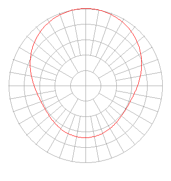
| Antenna Data for Antenna Id: 1006858 KCOR-CD DC File: -0000115083 Dielectric - TLP-12B/VP Service: DC Standard Pattern: N |  | ||||||||||||||||||||
| Azimuth | Ratio | Azimuth | Ratio | Azimuth | Ratio | Azimuth | Ratio | ||||||||||||||
| 0 | 1.000 | 10 | 0.996 | 20 | 0.980 | 30 | 0.955 | ||||||||||||||
| 40 | 0.920 | 50 | 0.877 | 60 | 0.828 | 70 | 0.776 | ||||||||||||||
| 80 | 0.724 | 90 | 0.678 | 100 | 0.641 | 110 | 0.617 | ||||||||||||||
| 120 | 0.608 | 130 | 0.612 | 140 | 0.625 | 150 | 0.642 | ||||||||||||||
| 160 | 0.659 | 170 | 0.671 | 180 | 0.676 | 190 | 0.672 | ||||||||||||||
| 200 | 0.662 | 210 | 0.646 | 220 | 0.628 | 230 | 0.614 | ||||||||||||||
| 240 | 0.608 | 250 | 0.614 | 260 | 0.635 | 270 | 0.669 | ||||||||||||||
| 280 | 0.714 | 290 | 0.765 | 300 | 0.818 | 310 | 0.867 | ||||||||||||||
| 320 | 0.912 | 330 | 0.949 | 340 | 0.976 | 350 | 0.993 | ||||||||||||||
Structure Registration Number 1053689 Structure Type: TOWER Registered To: Crown Castle Towers 06-2 LLC Structure Address: 411 E Durango Blvd San Antonio, TX County Name: Bexar County ASR Issued: 05/05/2016 Date Built: 01/01/1998 Site Elevation: 192 m (630 ft.) Structure Height: 183.1 m (601 ft.) Height Overall: 184.1 m (604 ft.) Overall Height AMSL: 376.1 m (1234 ft.) FAA Determination: 06/17/1998 FAA Study #: 98-ASW-2105-OE Paint & Light FAA Chapters: 1, 3, 4, 13, 21 RED LIGHTS/PAINT. 29-25-06.0 N 98-29-32.0 W (NAD 83) 29-25-05.2 N 98-29-30.9 W (Converted to NAD 27) |
8551 NW 30th Terrace Miami, FL 33122 Phone: 310-348-3600 Corporation | Title: SVP Assoc Gen Coun Gov and Reg Aff Date: 05/29/2020 Application Certifier Unimas Partnership of San Antonio Unimas Partnership of San Antonio 5999 Center Drive Los Angeles, CA 90045 Applicant Matthew S. Delnero Covington & Burling LLP One Citycenter 850 Tenth Street, NW Washington, DC 20001 Karl D Lahm, P.E Broadcast Transmission Services, LLC Rapid City, MI 49676 | |||||||||||||||||||