FCCInfo.com
A Service of Cavell, Mertz & Associates, Inc.
(855) FCC-INFO
|
|
KTSF-TV from 09/09/1980 KTSF from ??? |
Virtual Channel 26 |
|
||||||||||||||||||||||
|
|
KTSF is a channel sharing guest of KDTV-DT, San Francisco, California Status: LIC Application Accepted: 05/14/2020 License Expires: 12/01/2030 File Number: 0000113739 FCC Website Links: LMS Facility Details This Application Other KTSF Applications Including Superseded Applications Service Contour - Open Street Map or USGS Map (41 dBu) Service Contour - KML / Google Earth (41 dBu) Public Inspection Files Rabbit Ears Info Search for KTSF Site Location: 37-29-57.0 N 121-52-20.0 W (NAD 83) Site Location: 37-29-57.2 N 121-52-16.2 W (Converted to NAD 27) ERP: 475 kW Polarization: Elliptically polarized HAAT: 701.3 m (2301 ft.) Electrical Beam Tilt: 1.5 degrees R/C AGL: 126.7 m (416 ft.) R/C AMSL: 921 m (3022 ft.) Site Elevation: 794.3 m. (2606 ft.) Height Overall*: 135 m (443 ft.) (* As Filed In This Application, may differ from ASR Data, Below.) Directional Antenna - Antenna Make/Model: R.F. Systems SAA20-KDTV-E600-ET5R-20 Antenna ID: 1006784 Polarization: Elliptically polarized | ||||||||||||||||||||||||
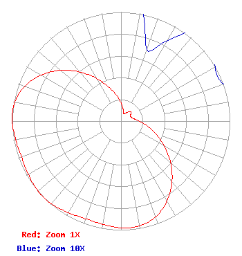
| Antenna Data for Antenna Id: 1006784 KTSF DT File: -0000113739 R.F. Systems - SAA20-KDTV-E600-ET5R-20 Service: DT Standard Pattern: N |  | ||||||||||||||||||||||||
| Azimuth | Ratio | Azimuth | Ratio | Azimuth | Ratio | Azimuth | Ratio | ||||||||||||||||||
| 0 | 0.170 | 10 | 0.110 | 20 | 0.070 | 30 | 0.085 | ||||||||||||||||||
| 40 | 0.110 | 45 | 0.125 | 50 | 0.120 | 60 | 0.100 | ||||||||||||||||||
| 70 | 0.100 | 80 | 0.120 | 90 | 0.170 | 100 | 0.242 | ||||||||||||||||||
| 110 | 0.338 | 120 | 0.459 | 130 | 0.595 | 140 | 0.728 | ||||||||||||||||||
| 150 | 0.846 | 160 | 0.933 | 170 | 0.977 | 180 | 0.980 | ||||||||||||||||||
| 190 | 0.961 | 200 | 0.953 | 210 | 0.970 | 220 | 0.992 | ||||||||||||||||||
| 227 | 0.998 | 230 | 0.997 | 240 | 0.982 | 250 | 0.972 | ||||||||||||||||||
| 260 | 0.982 | 270 | 0.999 | 273 | 1.000 | 280 | 0.990 | ||||||||||||||||||
| 290 | 0.939 | 300 | 0.845 | 310 | 0.724 | 320 | 0.588 | ||||||||||||||||||
| 330 | 0.454 | 340 | 0.335 | 350 | 0.241 | ||||||||||||||||||||
Structure Registration Number 1044718 [ASR Heights Differ from KTSF Application] Structure Type: GTOWER Registered To: SBA Towers XI, LLC Structure Address: Mount Allison 3 Mi E 9526 Weller Road (ca1899d-a) Fremont, CA County Name: Alameda County ASR Issued: 01/03/2025 Date Built: 02/25/1998 Site Elevation: 794.3 m (2606 ft.) Structure Height: 115.8 m (380 ft.) Height Overall: 122.8 m (403 ft.) Overall Height AMSL: 917.1 m (3009 ft.) FAA Determination: 12/18/2024 FAA Study #: 2024-AWP-13707-OE FAA Circular #: 70/7460-1J Paint & Light FAA Chapters: 8, 13 OM&L to remain the same as prior study = A MED-DUAL SYSTEM 37-29-57.7 N 121-52-20.7 W (NAD 83) 37-29-57.9 N 121-52-16.9 W (Converted to NAD 27) |
100 Valley Drive Brisbane, CA 94005 Phone: 415-468-2626 Limited Partnership | Application Certifier Lincoln Broadcasting Company, A California LP Lincoln Broadcasting Company, A California LP 100 Valley Drive Brisbane, CA 94005 Applicant Melodie A. Virtue Garvey Schubert Barer 1000 Potomac Street, NW Suite 200 Washington, DC 20007 FCC Counsel | |||||||||||||||||||||||
| |||||||||||||||||||||||||