FCCInfo.com
A Service of Cavell, Mertz & Associates, Inc.
(855) FCC-INFO
|
|
KVSD-LP from 01/21/2013 K26FA from 11/07/1996 K60EL from 05/28/1991 891208QH from ??? |
|
|
||||||||||||||||
|
|
Status: STA – Special Temporary Authority Application Accepted: 06/02/2020 STA Expires: 12/01/2030 File Number: 0000115694 FCC Website Links: LMS Facility Details This Application Other KVSD-LD Applications Including Superseded Applications Service Contour - Open Street Map or USGS Map (51 dBu) Service Contour - KML / Google Earth (51 dBu) Rabbit Ears Info Search for KVSD-LD Site Location: 33-00-32.0 N 116-58-19.0 W (NAD 83) Site Location: 33-00-31.8 N 116-58-15.9 W (Converted to NAD 27) ERP: 7 kW R/C AGL: 15.2 m (50 ft.) R/C AMSL: 895.2 m (2937 ft.) Emission Mask: Full Service Site Elevation: 880 m. (2887 ft.) Height Overall*: 28 m (92 ft.) (* As Filed In This Application, may differ from ASR Data, Below.) Directional Antenna - Antenna Make/Model: Propagation System Inc PSIUP2-CUSTOM Antenna ID: 107253 | ||||||||||||||||||
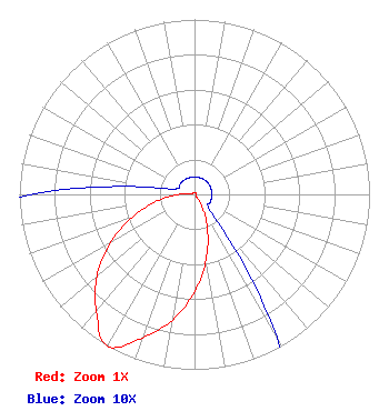
| Antenna Data for Antenna Id: 107253 KVSD-LD LD File: -0000115694 Propagation System Inc - PSIUP2-CUSTOM Service: LD Standard Pattern: Y Pattern and Field Values Include a 200° Clockwise Rotation |  | ||||||||||||||||||
| Azimuth | Ratio | Azimuth | Ratio | Azimuth | Ratio | Azimuth | Ratio | ||||||||||||
| 0 | 0.010 | 10 | 0.010 | 20 | 0.010 | 30 | 0.010 | ||||||||||||
| 40 | 0.010 | 50 | 0.010 | 60 | 0.010 | 70 | 0.010 | ||||||||||||
| 80 | 0.010 | 90 | 0.010 | 100 | 0.010 | 110 | 0.010 | ||||||||||||
| 120 | 0.010 | 130 | 0.010 | 140 | 0.021 | 150 | 0.094 | ||||||||||||
| 160 | 0.218 | 170 | 0.378 | 180 | 0.556 | 190 | 0.729 | ||||||||||||
| 200 | 0.872 | 210 | 1.000 | 220 | 0.872 | 230 | 0.729 | ||||||||||||
| 240 | 0.556 | 250 | 0.378 | 260 | 0.218 | 270 | 0.094 | ||||||||||||
| 280 | 0.021 | 290 | 0.010 | 300 | 0.010 | 310 | 0.010 | ||||||||||||
| 320 | 0.010 | 330 | 0.010 | 340 | 0.010 | 350 | 0.010 | ||||||||||||
Structure Registration Number 1026468 Structure Type: TOWER Registered To: Palomar Communications, Inc. Structure Address: Woodson Mountain Near Poway, CA County Name: San Diego County ASR Issued: 11/30/2022 Date Built: 01/01/1980 Site Elevation: 880 m (2887 ft.) Structure Height: 28 m (92 ft.) Height Overall: 28 m (92 ft.) Overall Height AMSL: 908 m (2979 ft.) FAA Determination: 08/14/1997 FAA Study #: 97-AWP-1915-OE Paint & Light FAA Chapters: NONE Removed expiration date from determination. Scenario 1./jjs/case#635066 33-00-32.0 N 116-58-19.0 W (NAD 83) 33-00-31.8 N 116-58-15.9 W (Converted to NAD 27) |
3901 Highway 121 South Bedford, TX 76021 Phone: 817-571-1229 Not-for-Profit | Title: President Date: 06/02/2020 Application Certifier D'Amico Brothers Broadcasting, Corp. D'Amico Brothers Broadcasting, Corp. 1119 S. Mission Rd. #353 Fallbrook, CA 92028 Applicant Kevin T. Fisher Smith and Fisher 4791 Wintergreen Court Woodbridge, VA 22192 Engineering Consultant Davina S. Sashkin Fletcher, Heald and Hildreth, P.L.C. 1300 N. 17th St. 11th Floor Arlington, VA 22209 Legal Counsel | |||||||||||||||||
| |||||||||||||||||||