|
K35OL-D
Call Sign History
K35OL-D from 07/13/2020
K42GI-D from 06/27/2011
K42GI from 11/04/2003
|
Channel 35DT
|
Yuma, CO
|
|
Status: LIC
Application Accepted: 07/13/2020
License Expires: 04/01/2030
File Number: 0000117622
FCC Website Links:
LMS Facility Details
This Application
Other K35OL-D Applications
Including Superseded Applications
Service Contour - Open Street Map or USGS Map (51 dBu)
Service Contour - KML / Google Earth (51 dBu)
Rabbit Ears Info Search for K35OL-D
Site Location: 40-08-35.0 N 102-48-53.0 W (NAD 83)
Site Location: 40-08-35.1 N 102-48-51.2 W (Converted to NAD 27)
ERP: 0.5 kW
Polarization: Horizontally polarized
Electrical Beam Tilt: 1.75 degrees
R/C AGL: 119.5 m (392 ft.)
R/C AMSL: 1401.8 m (4599 ft.)
Emission Mask: Simple
Site Elevation: 1282.3 m. (4207 ft.)
Height Overall*: 122.8 m (403 ft.)
(* As Filed In This Application, may differ from ASR Data, Below.)
Directional Antenna - Antenna Make/Model: Scala 2X2KBBU
Antenna ID: 20727
Polarization: Horizontally polarized
| Primary Station |
| KUSA |
Ch. 9 | Denver, Colorado |
|
Antenna Data for Antenna Id: 20727
K35OL-D LD File: -0000117622
Scala - 2X2KBBU
Service: LD
Standard Pattern: Y
Pattern and Field Values Include a 110° Clockwise Rotation
|
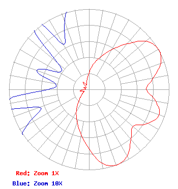 |
| Azimuth | Ratio | Azimuth | Ratio | Azimuth | Ratio | Azimuth | Ratio |
| 0 | 0.202 | 10 | 0.316 | 20 | 0.432 | 30 | 0.570 |
| 40 | 0.738 | 50 | 0.931 | 60 | 1.000 | 70 | 0.955 |
| 80 | 0.813 | 90 | 0.717 | 100 | 0.846 | 110 | 0.931 |
| 120 | 0.846 | 130 | 0.717 | 140 | 0.813 | 150 | 0.955 |
| 160 | 1.000 | 170 | 0.931 | 180 | 0.738 | 190 | 0.570 |
| 200 | 0.432 | 210 | 0.316 | 220 | 0.202 | 230 | 0.131 |
| 240 | 0.089 | 250 | 0.065 | 260 | 0.116 | 270 | 0.051 |
| 280 | 0.043 | 290 | 0.069 | 300 | 0.043 | 310 | 0.051 |
| 320 | 0.116 | 330 | 0.065 | 340 | 0.089 | 350 | 0.131 |
|
Structure Information
Structure Registration Number 1025960
Structure Type: TOWER
Registered To:
REGION 1 TRANSLATORS ASSOCIATION
Structure Address:
Hwy 34 & Co Rd Zz 5 Mi Wnw
Yuma, CO
County Name: Washington County
ASR Issued: 04/08/2014
Date Built: 01/01/1997
Site Elevation: 1282.3 m (4207 ft.)
Structure Height: 117.4 m (385 ft.)
Height Overall: 122.8 m (403 ft.)
Overall Height AMSL: 1405.1 m (4610 ft.)
FAA Determination: 07/01/1997
FAA Study #: 97-ANM-0791-OE
FAA Circular #: 70/7460-1J
Paint & Light FAA Chapters: 6
40-08-35.0 N 102-48-53.0 W (NAD 83)
40-08-35.1 N 102-48-51.2 W
(Converted to NAD 27)
|
K35OL-D Licensee Information
Region 1 Translator Association
221 S Interocean Ave
Holyoke, CO 80734
Phone: 970-854-3778
Government Entity | 0000117622 Applicant Information
Edward R Lake
Title: Chief Operator
Date: 07/13/2020
Application Certifier
Region 1 Translator Association
Region 1 Translator Association
221 S Interocean Ave
Holyoke, CO 80734
Applicant
Edward R Lake
RF Systems LLC
323 W. 4th Ave
Yuma, CO 80759
Chief Operator
|
Associated Land Mobile Licenses
|
| (No Records Found) |
| Associated Microwave Licenses
|
| (No Records Found) |
|
