FCCInfo.com
A Service of Cavell, Mertz & Associates, Inc.
(855) FCC-INFO
|
|
WSLS from ??? |
Virtual Channel 10 |  |
|
|||||||||||||||||||||||||||
|
|
Status: LIC Application Accepted: 10/19/2020 License Expires: 10/01/2028 File Number: 0000124863 FCC Website Links: LMS Facility Details This Application Other WSLS-TV Applications Including Superseded Applications Service Contour - Open Street Map or USGS Map (41 dBu) Service Contour - KML / Google Earth (41 dBu) Public Inspection Files Rabbit Ears Info Search for WSLS-TV Site Location: 37-12-03.3 N 80-08-52.8 W (NAD 83) Site Location: 37-12-02.8 N 80-08-53.7 W (Converted to NAD 27) ERP: 210 kW Polarization: Elliptically polarized HAAT: 591.4 m (1940 ft.) Electrical Beam Tilt: 0.5 degrees R/C AGL: 41.5 m (136 ft.) R/C AMSL: 1175.4 m (3856 ft.) Site Elevation: 1133.9 m. (3720 ft.) Height Overall*: 74 m (243 ft.) (* As Filed In This Application, may differ from ASR Data, Below.) Directional Antenna - Antenna Make/Model: Dielectric TLP-24H (C)/VP Antenna ID: 1007472 Polarization: Elliptically polarized | ||||||||||||||||||||||||||||||
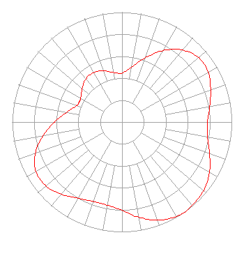
| Antenna Data for Antenna Id: 1007472 WSLS-TV DX File: -0000124863 Dielectric - TLP-24H (C)/VP Service: DX Standard Pattern: N |  | ||||||||||||||||||||||||||||||
| Azimuth | Ratio | Azimuth | Ratio | Azimuth | Ratio | Azimuth | Ratio | ||||||||||||||||||||||||
| 0 | 0.447 | 10 | 0.507 | 20 | 0.622 | 30 | 0.752 | ||||||||||||||||||||||||
| 40 | 0.856 | 50 | 0.912 | 60 | 0.907 | 70 | 0.859 | ||||||||||||||||||||||||
| 80 | 0.812 | 90 | 0.779 | 100 | 0.791 | 110 | 0.849 | ||||||||||||||||||||||||
| 120 | 0.919 | 130 | 0.970 | 140 | 0.994 | 145 | 1.000 | ||||||||||||||||||||||||
| 150 | 0.991 | 160 | 0.951 | 170 | 0.881 | 180 | 0.804 | ||||||||||||||||||||||||
| 190 | 0.768 | 200 | 0.770 | 210 | 0.800 | 220 | 0.858 | ||||||||||||||||||||||||
| 230 | 0.904 | 240 | 0.904 | 250 | 0.841 | 260 | 0.731 | ||||||||||||||||||||||||
| 270 | 0.615 | 280 | 0.510 | 290 | 0.439 | 295 | 0.430 | ||||||||||||||||||||||||
| 300 | 0.436 | 310 | 0.473 | 320 | 0.512 | 330 | 0.520 | ||||||||||||||||||||||||
| 340 | 0.496 | 350 | 0.459 | 357 | 0.444 | ||||||||||||||||||||||||||
Structure Registration Number 1024381 Structure Type: GTOWER Registered To: Graham Media Group, Virginia, LLC Structure Address: Atop Poor Mountain Roanoke, VA County Name: Roanoke County ASR Issued: 07/08/2021 Date Built: 10/08/2021 Site Elevation: 1133.9 m (3720 ft.) Structure Height: 52.1 m (171 ft.) Height Overall: 74 m (243 ft.) Overall Height AMSL: 1207.9 m (3963 ft.) FAA Determination: 06/25/2018 FAA Study #: 2018-AEA-7322-OE FAA Circular #: 70/7460-1K Paint & Light FAA Chapters: 4, 6, 12 PRIOR STUDY 2007-AEA-4519-OE 37-12-03.3 N 80-08-52.8 W (NAD 83) 37-12-02.8 N 80-08-53.7 W (Converted to NAD 27) |
821 5th Street NE Roanoke, VA 24016 Phone: 540-512-1542 Limited Liability Company | Title: Director of Technology Date: 10/19/2020 Application Certifier D/B/A WSLS-TV Graham Media Group, Virginia, LLC 821 5th Street NE Roanoke, VA 24016 Applicant William T. Godfrey, Jr Kessler and Gehman Associates, Inc. Kessler and Gehman Associates, Inc. 507-D NW 60th Street Gainesville, FL 32607-2055 Consulting Engineers Jennifer Johnson, Esq. Covington & Burling LLP One Citycenter 850 Tenth Street, N.W. Washington, DC 20001 Legal Counsel | |||||||||||||||||||||||||||||
|
| ||||||||||||||||||||||||||||||