FCCInfo.com
A Service of Cavell, Mertz & Associates, Inc.
(855) FCC-INFO
|
|
KUSA-TV from 03/19/1984 KBTV from ??? |
Virtual Channel 9 |  |
|
||||||||||||||||||||||||||||||||||||||||||||||||||||||||||||||||||||||||||||||||||||||||||||||||||||||
|
|
Status: LIC Application Accepted: 12/02/2020 License Expires: 04/01/2022 File Number: 0000129226 FCC Website Links: LMS Facility Details This Application Other KUSA Applications Including Superseded Applications Service Contour - Open Street Map or USGS Map (36 dBu) Service Contour - KML / Google Earth (36 dBu) Public Inspection Files Rabbit Ears Info Search for KUSA Site Location: 39-43-50.6 N 105-13-55.6 W (NAD 83) Site Location: 39-43-50.6 N 105-13-53.6 W (Converted to NAD 27) ERP: 45 kW Polarization: Circularly polarized HAAT: 352.4 m (1156 ft.) Electrical Beam Tilt: 1 degree R/C AGL: 192 m (630 ft.) R/C AMSL: 2360.8 m (7745 ft.) Site Elevation: 2168.8 m. (7115 ft.) Height Overall*: 223.8 m (734 ft.) (* As Filed In This Application, may differ from ASR Data, Below.) Directional Antenna - Antenna Make/Model: DIELECTRIC DCBR-C3-4HA/12H-2-B Antenna ID: 90233 Polarization: Circularly polarized
| |||||||||||||||||||||||||||||||||||||||||||||||||||||||||||||||||||||||||||||||||||||||||||||||||||||||||
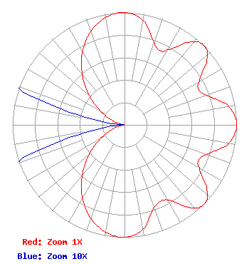
| Antenna Data for Antenna Id: 90233 KUSA DT File: -0000129226 DIELECTRIC - DCBR-C3-4HA/12H-2-B Service: DT Standard Pattern: Y |  | |||||||||||||||||||||||||||||||||||||||||||||||||||||||||||||||||||||||||||||||||||||||||||||||||||||||||
| Azimuth | Ratio | Azimuth | Ratio | Azimuth | Ratio | Azimuth | Ratio | |||||||||||||||||||||||||||||||||||||||||||||||||||||||||||||||||||||||||||||||||||||||||||||||||||
| 0 | 1.000 | 10 | 0.944 | 20 | 0.779 | 25 | 0.733 | |||||||||||||||||||||||||||||||||||||||||||||||||||||||||||||||||||||||||||||||||||||||||||||||||||
| 30 | 0.770 | 40 | 0.963 | 45 | 1.000 | 50 | 0.963 | |||||||||||||||||||||||||||||||||||||||||||||||||||||||||||||||||||||||||||||||||||||||||||||||||||
| 60 | 0.770 | 65 | 0.733 | 70 | 0.779 | 80 | 0.944 | |||||||||||||||||||||||||||||||||||||||||||||||||||||||||||||||||||||||||||||||||||||||||||||||||||
| 90 | 1.000 | 100 | 0.944 | 110 | 0.779 | 115 | 0.733 | |||||||||||||||||||||||||||||||||||||||||||||||||||||||||||||||||||||||||||||||||||||||||||||||||||
| 120 | 0.770 | 130 | 0.963 | 135 | 1.000 | 140 | 0.963 | |||||||||||||||||||||||||||||||||||||||||||||||||||||||||||||||||||||||||||||||||||||||||||||||||||
| 150 | 0.770 | 160 | 0.779 | 170 | 0.944 | 180 | 1.000 | |||||||||||||||||||||||||||||||||||||||||||||||||||||||||||||||||||||||||||||||||||||||||||||||||||
| 190 | 0.970 | 200 | 0.883 | 210 | 0.750 | 220 | 0.587 | |||||||||||||||||||||||||||||||||||||||||||||||||||||||||||||||||||||||||||||||||||||||||||||||||||
| 230 | 0.413 | 240 | 0.250 | 250 | 0.117 | 260 | 0.030 | |||||||||||||||||||||||||||||||||||||||||||||||||||||||||||||||||||||||||||||||||||||||||||||||||||
| 270 | 0.001 | 280 | 0.030 | 290 | 0.117 | 300 | 0.250 | |||||||||||||||||||||||||||||||||||||||||||||||||||||||||||||||||||||||||||||||||||||||||||||||||||
| 310 | 0.413 | 320 | 0.587 | 330 | 0.750 | 340 | 0.883 | |||||||||||||||||||||||||||||||||||||||||||||||||||||||||||||||||||||||||||||||||||||||||||||||||||
| 350 | 0.970 | |||||||||||||||||||||||||||||||||||||||||||||||||||||||||||||||||||||||||||||||||||||||||||||||||||||||||
Structure Registration Number 1058328 Structure Type: TOWER Registered To: LAKE CEDAR GROUP, L.L.C. Structure Address: Lookout Mountain, 21119 Cedar Lake Road, Jefferson County Golden, CO County Name: Jefferson County ASR Issued: 07/02/2008 Date Built: 06/01/2009 Site Elevation: 2168.8 m (7115 ft.) Structure Height: 189.1 m (620 ft.) Height Overall: 223.8 m (734 ft.) Overall Height AMSL: 2392.6 m (7850 ft.) FAA Determination: 07/01/2008 FAA Study #: 2008-ANM-2069-OE FAA Circular #: 70/7460-1K Paint & Light FAA Chapters: 3, 4, 5, 12 OM&L to remain the same as prior study = PAINT/RED LIGHTS 39-43-50.6 N 105-13-55.6 W (NAD 83) 39-43-50.6 N 105-13-53.6 W (Converted to NAD 27) |
Tegna, Inc. 8350 Broad Street, Suite 2000 Tysons, VA 22102 Phone: 703-873-6606 Corporation | Title: Secretary Date: 12/02/2020 Application Certifier Multimedia Holdings Corporation Tegna, Inc. 8350 Broad Street, Suite 2000 Tysons, VA 22102 Applicant Michael Beder, Esq Tegna Inc. 8350 Broad Street, Suite 2000 Tysons, VA 22102 Associate General Counsel | ||||||||||||||||||||||||||||||||||||||||||||||||||||||||||||||||||||||||||||||||||||||||||||||||||||||||
|
| |||||||||||||||||||||||||||||||||||||||||||||||||||||||||||||||||||||||||||||||||||||||||||||||||||||||||