FCCInfo.com
A Service of Cavell, Mertz & Associates, Inc.
(855) FCC-INFO
|
|
WARZ-CD from 03/13/2015 WARZ-LD from 08/10/2011 WARZ-LP from 03/22/1996 W35AR from 11/30/1988 880622PS from ??? |
Virtual Channel 34 |
|
|||||||||||||||||||
|
|
Status: LIC Application Accepted: 04/23/2021 License Expires: 12/01/2028 File Number: 0000143970 FCC Website Links: LMS Facility Details This Application Other WNGT-CD Applications Including Superseded Applications Service Contour - Open Street Map or USGS Map (51 dBu) Service Contour - KML / Google Earth (51 dBu) Public Inspection Files Rabbit Ears Info Search for WNGT-CD Site Location: 35-40-35.1 N 78-32-07.2 W (NAD 83) Site Location: 35-40-34.5 N 78-32-08.2 W (Converted to NAD 27) ERP: 15 kW Polarization: Circularly polarized Electrical Beam Tilt: 1.25 degrees R/C AGL: 317 m (1040 ft.) R/C AMSL: 415.7 m (1364 ft.) Emission Mask: Full Service Site Elevation: 98.7 m. (324 ft.) Height Overall*: 609.5 m (2000 ft.) (* As Filed In This Application, may differ from ASR Data, Below.) Directional Antenna - Antenna Make/Model: Electronics Research Inc. ALP12M5-CSW-23 Antenna ID: 1008116 Polarization: Circularly polarized | |||||||||||||||||||||
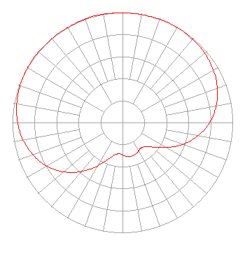
| Antenna Data for Antenna Id: 1008116 WNGT-CD DC File: -0000143970 Electronics Research Inc. - ALP12M5-CSW-23 Service: DC Standard Pattern: N Pattern and Field Values Include a 345° Clockwise Rotation |  | |||||||||||||||||||||
| Azimuth | Ratio | Azimuth | Ratio | Azimuth | Ratio | Azimuth | Ratio | |||||||||||||||
| 5 | 0.994 | 15 | 0.994 | 25 | 0.995 | 35 | 0.991 | |||||||||||||||
| 45 | 0.982 | 55 | 0.964 | 65 | 0.936 | 75 | 0.891 | |||||||||||||||
| 85 | 0.830 | 95 | 0.747 | 105 | 0.640 | 115 | 0.519 | |||||||||||||||
| 125 | 0.395 | 135 | 0.308 | 145 | 0.286 | 155 | 0.306 | |||||||||||||||
| 165 | 0.316 | 175 | 0.306 | 185 | 0.286 | 195 | 0.308 | |||||||||||||||
| 205 | 0.395 | 215 | 0.519 | 225 | 0.640 | 235 | 0.747 | |||||||||||||||
| 245 | 0.830 | 255 | 0.891 | 265 | 0.936 | 275 | 0.964 | |||||||||||||||
| 285 | 0.982 | 295 | 0.991 | 305 | 0.995 | 315 | 0.994 | |||||||||||||||
| 325 | 0.994 | 335 | 0.995 | 345 | 1.000 | 355 | 0.995 | |||||||||||||||
Structure Registration Number 1006703 Structure Type: Registered To: Auburn Tower Partnership Structure Address: 5033 Tv Tower Rd Garner, NC County Name: Wake County ASR Issued: 08/21/2025 Date Built: 06/17/1991 Site Elevation: 98.7 m (324 ft.) Structure Height: 569.7 m (1869 ft.) Height Overall: 609.5 m (2000 ft.) Overall Height AMSL: 708.2 m (2323 ft.) FAA Determination: 09/24/2003 FAA Study #: 2003-ASO-4390-OE FAA Circular #: 70/7460-1G Paint & Light FAA Chapters: 4, 6, 9 Continue As Is OM&L = 24-HR HI-STROBES 35-40-35.1 N 78-32-07.2 W (NAD 83) 35-40-34.5 N 78-32-08.2 W (Converted to NAD 27) |
2619 Western Boulevard Raleigh, NC 27606 Phone: 919-821-8628 Corporation | Title: Vice President Date: 04/23/2021 Application Certifier Capitol Broadcasting Company, Inc. 2619 Western Boulevard Raleigh, NC 27606 Applicant Louis R Dutreil, Jr Dutreil Lundin & Rackley Inc 5120 Station Way Sarasota, FL 34233-3221 Technical Consultant David A. O'Connor Wilkinson Barker Knauer, LLP 1800 M Street, NW Suite 800N Washington, DC 20036 Legal Counsel | ||||||||||||||||||||