FCCInfo.com
A Service of Cavell, Mertz & Associates, Inc.
(855) FCC-INFO
|
|
WWWJ-CD from 08/10/2017 WJYL-CD from 07/15/2009 WJYL-CA from 01/22/2009 WNDA-CA from 07/10/2008 WVHF-CA from 07/06/2004 WVHF-LP from 01/04/2002 W05BE from 05/29/1987 W05BA from 05/28/1985 810217HK from ??? |
|
|
||||||||||||||||
|
|
Status: LIC Application Accepted: 10/01/2021 License Expires: 08/01/2029 File Number: 0000162183 FCC Website Links: LMS Facility Details This Application Other WJYL-CD Applications Including Superseded Applications Service Contour - Open Street Map or USGS Map (51 dBu) Service Contour - KML / Google Earth (51 dBu) Public Inspection Files Rabbit Ears Info Search for WJYL-CD Site Location: 38-22-08.4 N 85-49-47.6 W (NAD 83) Site Location: 38-22-08.2 N 85-49-47.7 W (Converted to NAD 27) ERP: 15 kW Polarization: Horizontally polarized Electrical Beam Tilt: 0.5 degrees R/C AGL: 221 m (725 ft.) R/C AMSL: 520.6 m (1708 ft.) Emission Mask: Full Service Site Elevation: 299.6 m. (983 ft.) Height Overall*: 292.9 m (961 ft.) (* As Filed In This Application, may differ from ASR Data, Below.) Directional Antenna - Antenna Make/Model: DIELECTRIC TFU-24WB C-160H Antenna ID: 1004580 Polarization: Horizontally polarized | ||||||||||||||||||
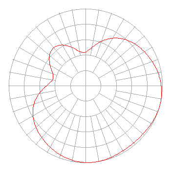
| Antenna Data for Antenna Id: 1004580 WJYL-CD DC File: -0000162183 DIELECTRIC - TFU-24WB C-160H Service: DC Standard Pattern: Y Pattern and Field Values Include a 140° Clockwise Rotation |  | ||||||||||||||||||
| Azimuth | Ratio | Azimuth | Ratio | Azimuth | Ratio | Azimuth | Ratio | ||||||||||||
| 0 | 0.433 | 10 | 0.503 | 20 | 0.611 | 30 | 0.711 | ||||||||||||
| 40 | 0.786 | 50 | 0.840 | 60 | 0.882 | 70 | 0.920 | ||||||||||||
| 80 | 0.956 | 90 | 0.984 | 100 | 0.998 | 105 | 1.000 | ||||||||||||
| 110 | 0.998 | 120 | 0.987 | 130 | 0.976 | 140 | 0.971 | ||||||||||||
| 150 | 0.976 | 160 | 0.988 | 170 | 0.998 | 175 | 1.000 | ||||||||||||
| 180 | 0.998 | 190 | 0.984 | 200 | 0.956 | 210 | 0.921 | ||||||||||||
| 220 | 0.883 | 230 | 0.842 | 240 | 0.788 | 250 | 0.713 | ||||||||||||
| 260 | 0.612 | 270 | 0.504 | 280 | 0.435 | 290 | 0.452 | ||||||||||||
| 300 | 0.533 | 310 | 0.610 | 320 | 0.640 | 330 | 0.609 | ||||||||||||
| 340 | 0.531 | 350 | 0.450 | ||||||||||||||||
Structure Registration Number 1230057 Structure Type: GTOWER Registered To: P & B Towers LLC Structure Address: 7601 N. Skyline Drive New Albany, IN County Name: Floyd County ASR Issued: 03/10/2015 Date Built: 03/11/2015 Site Elevation: 299.6 m (983 ft.) Structure Height: 274.3 m (900 ft.) Height Overall: 292.9 m (961 ft.) Overall Height AMSL: 592.5 m (1944 ft.) FAA Determination: 02/24/2015 FAA Study #: 2015-AGL-2404-OE FAA Circular #: 70/7460-1K Paint & Light FAA Chapters: 4, 9, 12 PRIOR STUDY 2015-AGL-31-OE. FAA CHAPTERS 4,9,12 70/7460-1K WITH BIRD DEVIATION SPECIAL CONDITION. 38-22-08.4 N 85-49-47.6 W (NAD 83) 38-22-08.2 N 85-49-47.7 W (Converted to NAD 27) |
38955 Hills Tech Dr. Farmington Hills, MI 48331 Phone: 248-536-0776 Limited Liability Company | Title: Owner Date: 10/01/2021 Application Certifier Wjyl, LLC Wjyl, LLC P.O. Box 2605 Clarksville, IN 47131 Applicant Greg Best Greg Best Consulting, Inc 16100 Outlook Ave Stilwell, KS 66085 Joseph C. Chautin, III Hardy, Carey, Chautin & Balkin, LLP 1080 West Causeway Approach Mandeville, LA 70471 Legal Counsel David Brian Smith, Sr Wjyl-CD Clarksville, IN 47131 GM/Repack Manager | |||||||||||||||||