
FCCInfo.com
A Service of Cavell, Mertz & Associates, Inc.
(855) FCC-INFO
|
|
|
|
|
||||||||||||||||
|
|
WEKM-FM Channel: 201A 88.1 MHz Maysville, Kentucky Service: FM - A full-service FM station or application. Facility ID: 763940 Fac. Service: FM Status: CP Application Accepted: 11/05/2021 Application Granted: 12/20/2021 File Number: 0000166631 WEKM-FM CP Expires: 12/20/2024 Application Type: Non-Commercial Educational New NCE FM CP FCC Website Links: LMS Facility Details This Application Other WEKM-FM Applications Other WEKM-FM Applications in CDBS Including Superseded Applications Mailing Address Correspondence for WEKM-FM Correspondence related to application 0000166631 Service Contour - Open Street Map or USGS Map (60 dBu) Service Contour - KML / Google Earth (60 dBu) Public Inspection Files Facility Type: NON-COMMERCIAL EDUC. FM Class: A, A Zone I; I-A; or II station; with 0.1kW-6kW ERP and a class contour distance <=28km Site Location: 38-39-00.4 N 83-53-08.6 W (NAD 83) Site Location: 38-39-00.1 N 83-53-08.9 W (Converted to NAD 27) Effective Radiated Power: 2.2 kW Antenna Center HAAT: 100 m (328 ft.) Antenna Center AMSL: 340 m (1115 ft.) Antenna Center HAG: 47 m (154 ft.) Site Elevation: 292.3 m. (959 ft.) Height Overall*: 97.5 m (320 ft.) (* As Filed In This Application, may differ from ASR Data, Below.) Directional Antenna Antenna Make/Model: None Antenna ID: 69-2019-08-06 Polarization: | ||||||||||||||||||
| Antenna Data for Antenna Id: 69-2019-08-06 WEKM-FM FM File: -0000166631 None - Service: FM | 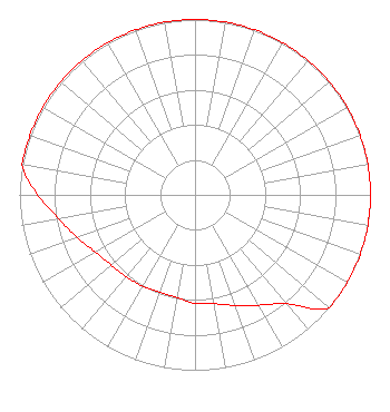 | ||||||||||||||||||
| Azimuth | Ratio | Azimuth | Ratio | Azimuth | Ratio | Azimuth | Ratio | ||||||||||||
| 0 | 1.000 | 10 | 1.000 | 20 | 1.000 | 30 | 1.000 | ||||||||||||
| 40 | 1.000 | 50 | 1.000 | 60 | 1.000 | 70 | 1.000 | ||||||||||||
| 80 | 1.000 | 90 | 1.000 | 100 | 1.000 | 110 | 1.000 | ||||||||||||
| 120 | 1.000 | 130 | 1.000 | 140 | 0.812 | 150 | 0.726 | ||||||||||||
| 160 | 0.671 | 170 | 0.631 | 180 | 0.619 | 190 | 0.594 | ||||||||||||
| 200 | 0.590 | 210 | 0.600 | 220 | 0.609 | 230 | 0.623 | ||||||||||||
| 240 | 0.654 | 250 | 0.714 | 260 | 0.788 | 270 | 0.896 | ||||||||||||
| 280 | 1.000 | 290 | 1.000 | 300 | 1.000 | 310 | 1.000 | ||||||||||||
| 320 | 1.000 | 330 | 1.000 | 340 | 1.000 | 350 | 1.000 | ||||||||||||
Structure Registration Number 1245221 Structure Type: TOWER Registered To: Cellco Partnership Structure Address: 4012 Barret Pike Road (fernleaf) Maysville, KY County Name: Mason County ASR Issued: 02/04/2019 Date Built: 07/13/2006 Site Elevation: 292.3 m (959 ft.) Structure Height: 91.4 m (300 ft.) Height Overall: 97.5 m (320 ft.) Overall Height AMSL: 389.8 m (1279 ft.) FAA Determination: 07/12/2006 FAA Study #: 2006-ASO-3859-OE FAA Circular #: 70/7460-1K Paint & Light FAA Chapters: 4, 8, 12 OM&L to remain the same as prior study = A MED-DUAL SYSTEM 38-39-00.4 N 83-53-08.6 W (NAD 83) 38-39-00.1 N 83-53-08.9 W (Converted to NAD 27) |
521 Lancaster Ave. 102 Perkins Bldg. Richmond, KY 40475 Phone: 859-622-1662 Government Entity | Title: Director And General Manager Date: 11/05/2021 Application Certifier Eastern Kentucky University 521 Lancaster Avenue 102 Perkins Building Richmond, KY 40475 Applicant Eastern Kentucky University 521 Lancaster Ave. 102 Perkins Bldg. Richmond, KY 40475 Applicant Ernest T Sanchez The Sanchez Law Firm Pc 1629 K Street Nw, Suite 300 Washington, DC 20006 Attorney Timothy Z Sawyer T Z Sawyer Technical Consultants 2130 Hutchison Grove Court Suite 100 Falls Church, VA 22043 Technical Consultant | |||||||||||||||||