|
W294CU Channel: 294D 106.7 MHz
Lacrosse, Wisconsin
Service: FX - A translator or application for a translator.
Facility ID: 202363
FRN: 0002711885
Fac. Service: FX
Programming Delivery Method: Unspecified
Status: LIC
Application Accepted: 11/23/2021
Application Granted: 12/13/2021
File Number: 0000170885
License Expires: 12/01/2028
Application Type: License To Cover
FCC Website Links:
LMS Facility Details
This Application
Other W294CU Applications
Including Superseded Applications
Service Contour - Open Street Map or USGS Map (60 dBu)
Service Contour - KML / Google Earth (60 dBu)
Facility Type: FM STATION
Class: D, A Noncommercial educational operating with no more than 10W
Site Location: 44-05-28.0 N 91-20-17.0 W (NAD 83)
Site Location: 44-05-28.1 N 91-20-16.5 W (Converted to NAD 27)
Effective Radiated Power: 0.25 kW
Transmitter Output Power: 0.28 kW
Antenna Center AMSL: 555.6 m (1823 ft.)
Antenna Center HAG: 304.8 m (1000 ft.)
Site Elevation: 250.8 m. (823 ft.)
Height Overall*: 484.3 m (1589 ft.)
(* As Filed In This Application, may differ from ASR Data, Below.)
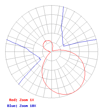
Directional Antenna
Antenna Make/Model: Scala CA2-CP
Antenna ID: 132635
Polarization: H
| Primary Station |
| WIZM |
Ch. 0 | La Crosse, Wisconsin |
|
Structure Information
Structure Registration Number 1035532
Structure Type: GTOWER
Registered To:
QueenB Television, LLC
Structure Address:
W19325 Silver Creek Rd
Galesville, WI
County Name: Trempealeau County
ASR Issued: 11/05/2020
Date Built: 01/05/2021
Site Elevation: 250.8 m (823 ft.)
Structure Height: 484 m (1588 ft.)
Height Overall: 484.3 m (1589 ft.)
Overall Height AMSL: 735.1 m (2412 ft.)
FAA Determination: 10/07/2020
FAA Study #: 2020-AGL-8150-OE
FAA Circular #: 70/7460-1L
Paint & Light FAA Chapters: 3, 4, 5, 12
44-05-28.0 N 91-20-17.0 W (NAD 83)
44-05-28.1 N 91-20-16.5 W
(Converted to NAD 27)
|
W294CU(FX) Licensee Information
Family Radio, Inc.
201 State Street
LA Crosse, WI 54601
Phone: 608-782-1230
Corporation | 0000170885 Applicant Information
Richard Trautschold
Title: President
Date: 11/23/2021
Application Certifier
Family Radio, Inc.
Family Radio, Inc.
201 State Street
LA Crosse, WI 54601
Applicant
David Oxenford
Wilkinson Barker Knauer, LLP
1800 M Street, N.W.
Suite 800N
Washington, DC 20036
Roy P Stype, III
Carl E. Smith Consulting Engineers
2324 North Cleveland-Massillon Road
Bath, OH 44210
Consulting Engineer
|