
FCCInfo.com
A Service of Cavell, Mertz & Associates, Inc.
(855) FCC-INFO
|
|
|
|
|
||||||||||||||||
|
|
Channel: 210A 89.9 MHz Kiron, Iowa Service: FM - A full-service FM station or application. Facility ID: 768939 Fac. Service: FM Status: CP Application Accepted: 01/28/2022 Application Granted: 03/07/2022 File Number: 0000167834 CP Expires: 03/07/2025 Application Type: Non-Commercial Educational Amendment FCC Website Links: LMS Facility Details This Application Other Applications Other Applications in CDBS Including Superseded Applications Mailing Address Correspondence for Correspondence related to application 0000167834 Service Contour - Open Street Map or USGS Map (60 dBu) Service Contour - KML / Google Earth (60 dBu) Facility Type: NON-COMMERCIAL EDUC. FM Class: A, A Zone I; I-A; or II station; with 0.1kW-6kW ERP and a class contour distance <=28km Site Location: 42-10-58.0 N 95-19-29.0 W (NAD 83) Site Location: 42-10-58.0 N 95-19-28.0 W (Converted to NAD 27) Effective Radiated Power: 0.1 kW Antenna Center HAAT: 3 m (10 ft.) Antenna Center AMSL: 428 m (1404 ft.) Antenna Center HAG: 10 m (33 ft.) Site Elevation: 418 m. (1371 ft.) Height Overall*: 79 m (259 ft.) (* As Filed In This Application, may differ from ASR Data, Below.) Directional Antenna Antenna Make/Model: None Antenna ID: 69-2019-08-06 Polarization: | ||||||||||||||||||
| Antenna Data for Antenna Id: 69-2019-08-06 FM File: -0000167834 None - Service: FM | 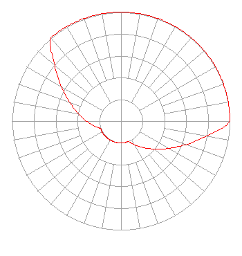 | ||||||||||||||||||
| Azimuth | Ratio | Azimuth | Ratio | Azimuth | Ratio | Azimuth | Ratio | ||||||||||||
| 0 | 1.000 | 10 | 1.000 | 20 | 1.000 | 30 | 1.000 | ||||||||||||
| 40 | 1.000 | 50 | 1.000 | 60 | 1.000 | 70 | 1.000 | ||||||||||||
| 80 | 1.000 | 90 | 1.000 | 100 | 0.795 | 110 | 0.632 | ||||||||||||
| 120 | 0.502 | 130 | 0.399 | 140 | 0.317 | 150 | 0.252 | ||||||||||||
| 160 | 0.201 | 170 | 0.201 | 180 | 0.201 | 190 | 0.201 | ||||||||||||
| 200 | 0.201 | 210 | 0.201 | 220 | 0.201 | 230 | 0.201 | ||||||||||||
| 240 | 0.201 | 250 | 0.201 | 260 | 0.252 | 270 | 0.317 | ||||||||||||
| 280 | 0.399 | 290 | 0.502 | 300 | 0.632 | 310 | 0.795 | ||||||||||||
| 320 | 1.000 | 330 | 1.000 | 340 | 1.000 | 350 | 1.000 | ||||||||||||
Structure Registration Number 1307024 Structure Type: LTOWER Registered To: Iowa 8-Monona Limited Partnership Structure Address: C Avenue & Highway 39 - 2147608 Kiron, IA County Name: Crawford County ASR Issued: 02/25/2021 Date Built: 02/24/2021 Site Elevation: 418.5 m (1373 ft.) Structure Height: 76.5 m (251 ft.) Height Overall: 79.2 m (260 ft.) Overall Height AMSL: 497.7 m (1633 ft.) FAA Determination: 09/05/2019 FAA Study #: 2018-ACE-1331-OE FAA Circular #: 70/7460-1L Paint & Light FAA Chapters: 4, 8, 12 Removed expiration date from determination. Scenario 1./jjs/case#635066 42-10-58.0 N 95-19-29.0 W (NAD 83) 42-10-58.0 N 95-19-28.0 W (Converted to NAD 27) |
3004 70th Ave Greeley, CO 80634 Phone: 970-302-8444 Not-for-Profit | Title: Director And President Date: 01/28/2022 Application Certifier YOUNGERS COLORADO BROADCASTING LLC Jkj Educational Foundation 3004 70th Ave Greeley, CO 80634 Applicant Kevin J. Youngers Jkj Educational Foundation 3004 70th Ave Greeley, CO 80634 | |||||||||||||||||