FCCInfo.com
A Service of Cavell, Mertz & Associates, Inc.
(855) FCC-INFO
|
|
KPQC from 07/21/1994 DKPQC from 06/30/1992 |
Virtual Channel 15 |  |
|
||||||||||||||||||
|
|
Status: LIC Application Accepted: 05/12/2022 License Expires: 06/01/2022 File Number: 0000190544 FCC Website Links: LMS Facility Details This Application Other KXVO Applications Including Superseded Applications Service Contour - Open Street Map or USGS Map (41 dBu) Service Contour - KML / Google Earth (41 dBu) Public Inspection Files Rabbit Ears Info Search for KXVO Site Location: 41-04-15.9 N 96-13-32.3 W (NAD 83) Site Location: 41-04-15.9 N 96-13-31.2 W (Converted to NAD 27) ERP: 630 kW Polarization: Elliptically polarized HAAT: 434 m (1424 ft.) Electrical Beam Tilt: 0.5 degrees R/C AGL: 411.5 m (1350 ft.) R/C AMSL: 781.3 m (2563 ft.) Site Elevation: 369.8 m. (1213 ft.) Height Overall*: 464 m (1522 ft.) (* As Filed In This Application, may differ from ASR Data, Below.) Directional Antenna - Antenna Make/Model: Dielectric TFU-24WB/VP-R C160 Antenna ID: 1009569 Polarization: Elliptically polarized | |||||||||||||||||||||
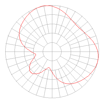
| Antenna Data for Antenna Id: 1009569 KXVO DX File: -0000190544 Dielectric - TFU-24WB/VP-R C160 Service: DX Standard Pattern: N |  | |||||||||||||||||||||
| Azimuth | Ratio | Azimuth | Ratio | Azimuth | Ratio | Azimuth | Ratio | |||||||||||||||
| 0 | 0.978 | 10 | 0.927 | 20 | 0.863 | 30 | 0.807 | |||||||||||||||
| 40 | 0.775 | 45 | 0.771 | 50 | 0.775 | 60 | 0.806 | |||||||||||||||
| 70 | 0.862 | 80 | 0.926 | 90 | 0.977 | 100 | 0.999 | |||||||||||||||
| 110 | 0.987 | 120 | 0.952 | 130 | 0.907 | 140 | 0.860 | |||||||||||||||
| 150 | 0.803 | 160 | 0.717 | 170 | 0.591 | 180 | 0.444 | |||||||||||||||
| 190 | 0.354 | 200 | 0.412 | 210 | 0.537 | 220 | 0.623 | |||||||||||||||
| 225 | 0.635 | 230 | 0.623 | 240 | 0.537 | 250 | 0.412 | |||||||||||||||
| 260 | 0.355 | 270 | 0.446 | 280 | 0.594 | 290 | 0.721 | |||||||||||||||
| 300 | 0.807 | 310 | 0.863 | 320 | 0.910 | 330 | 0.954 | |||||||||||||||
| 340 | 0.988 | 350 | 1.000 | |||||||||||||||||||
Structure Registration Number 1026025 Structure Type: TOWER Registered To: Sinclair Television of Omaha, LLC Structure Address: 19801 Pflug Rd Gretna, NE County Name: Sarpy County ASR Issued: 01/11/2017 Date Built: 11/01/2005 Site Elevation: 369.8 m (1213 ft.) Structure Height: 442.1 m (1450 ft.) Height Overall: 464 m (1522 ft.) Overall Height AMSL: 833.8 m (2736 ft.) FAA Determination: 06/24/2005 FAA Study #: 2005-ACE-1664-OE Paint & Light FAA Chapters: A5, H, 1, 3, 10, 19, 21, 23 PRIOR STUDY 2005-ACE-1072-OE 41-04-15.9 N 96-13-32.3 W (NAD 83) 41-04-15.9 N 96-13-31.2 W (Converted to NAD 27) |
609 West Acequia Avenue Suite B Visalia, CA 93291 Phone: 559-625-4234 Limited Liability Company | Title: President Date: 05/12/2022 Application Certifier Mitts Telecasting Company, LLC 609 West Acequia Avenue Suite B Visalia, CA 93291 Applicant Dan Buchholz Mitt's Telecasting LLC 4625 Farnam Street Omaha, NE 68132 Christina Burrow Cooley LLP 1299 Pennsylvania Avenue, NW Suite 700 Washington, DC 20004 FCC Counsel John E. Hidle, PE Carl T. Jones Corporation 7901 Yarnwood Court Springfield, VA 22153 Consulting Engineer | ||||||||||||||||||||