
FCCInfo.com
A Service of Cavell, Mertz & Associates, Inc.
(855) FCC-INFO
|
|
|
|
|
||||||||||||||||
|
|
WLHE Channel: 204A 88.7 MHz Cadiz, Kentucky Service: FM - A full-service FM station or application. Facility ID: 765780 Fac. Service: FM Status: LIC Application Accepted: 02/08/2023 Application Granted: 02/27/2023 File Number: 0000210493 License Expires: 08/01/2028 Application Type: License To Cover FCC Website Links: LMS Facility Details This Application Other WLHE Applications Other WLHE Applications in CDBS Including Superseded Applications Mailing Address Correspondence for WLHE Correspondence related to application 0000210493 Service Contour - Open Street Map or USGS Map (60 dBu) Service Contour - KML / Google Earth (60 dBu) Public Inspection Files Facility Type: NON-COMMERCIAL EDUC. FM Class: A, A Zone I; I-A; or II station; with 0.1kW-6kW ERP and a class contour distance <=28km Site Location: 36-48-32.0 N 87-56-12.0 W (NAD 83) Site Location: 36-48-31.8 N 87-56-11.9 W (Converted to NAD 27) Effective Radiated Power: 2.5 kW Transmitter Output Power: 1.5 kW Antenna Center HAAT: 87 m (285 ft.) Antenna Center AMSL: 231 m (758 ft.) Antenna Center HAG: 66 m (217 ft.) Site Elevation: 164.6 m. (540 ft.) Height Overall*: 78 m (256 ft.) (* As Filed In This Application, may differ from ASR Data, Below.) Directional Antenna Antenna Make/Model: Propagation System Inc FML-4A-50WS-DA, 4 sections Antenna ID: 0 Polarization: H | ||||||||||||||||||
| Antenna Data for Antenna Id: 0 WLHE FM File: -0000210493 Propagation System Inc - FML-4A-50WS-DA, 4 sections Service: FM | 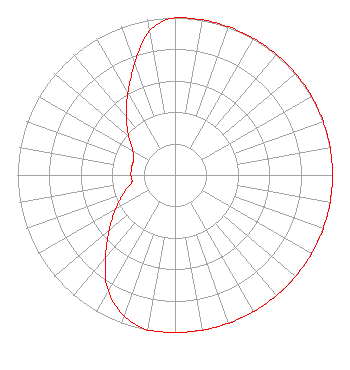 | ||||||||||||||||||
| Azimuth | Ratio | Azimuth | Ratio | Azimuth | Ratio | Azimuth | Ratio | ||||||||||||
| 0 | 1.000 | 10 | 1.000 | 20 | 1.000 | 30 | 1.000 | ||||||||||||
| 40 | 1.000 | 50 | 1.000 | 60 | 1.000 | 70 | 1.000 | ||||||||||||
| 80 | 1.000 | 90 | 1.000 | 100 | 1.000 | 110 | 1.000 | ||||||||||||
| 120 | 1.000 | 130 | 1.000 | 140 | 1.000 | 150 | 1.000 | ||||||||||||
| 160 | 1.000 | 170 | 1.000 | 180 | 1.000 | 190 | 1.000 | ||||||||||||
| 200 | 0.950 | 210 | 0.850 | 220 | 0.685 | 230 | 0.545 | ||||||||||||
| 240 | 0.435 | 250 | 0.350 | 260 | 0.280 | 270 | 0.280 | ||||||||||||
| 280 | 0.280 | 290 | 0.280 | 300 | 0.310 | 310 | 0.385 | ||||||||||||
| 320 | 0.480 | 330 | 0.600 | 340 | 0.750 | 350 | 0.930 | ||||||||||||
Structure Registration Number 1020835 Structure Type: TOWER Registered To: Crown Castle South LLC Structure Address: Us Hwy 68 1/2 Mi W Of Barkley State Park Rd Canton, KY County Name: Trigg County ASR Issued: 05/06/2016 Date Built: 06/21/1997 Site Elevation: 164.6 m (540 ft.) Structure Height: 76.2 m (250 ft.) Height Overall: 78 m (256 ft.) Overall Height AMSL: 242.6 m (796 ft.) FAA Determination: 10/17/2001 FAA Study #: 01-ASO-4588-OE Paint & Light FAA Chapters: A1, H, 3, 11, 21, 23 OM&L TO REMAIN MED DUAL SYSTEM AS PER PRIOR STUDY 97-ASO-0162-OE 36-48-32.0 N 87-56-12.0 W (NAD 83) 36-48-31.8 N 87-56-11.9 W (Converted to NAD 27) |
Madisonville, KY 42431 Phone: 270-825-3004 Not-for-Profit | Title: Secretary Date: 02/08/2023 Application Certifier Madisonville Baptist Temple Inc. Madisonville, KY 42431 Applicant CHARLES M. ANDERSON Anderson Associates 5900 Lake Cyrus Drive Hoover, AL 42103 BROADCAST ENGINEERING CONSULTANT Seth L Williams Fletcher, Heald & Hildreth, Plc 1300 N. 17th Street Suite 1100 Arlington, VA 22209 | |||||||||||||||||