FCCInfo.com
A Service of Cavell, Mertz & Associates, Inc.
(855) FCC-INFO
|
|
KPBS-TV from 09/12/1980 KPBS from ??? |
Virtual Channel 15 |  |
|
||||||||||||||||||
|
|
Status: STA – Special Temporary Authority Application Accepted: 03/09/2023 STA Expires: 12/01/2030 File Number: 0000212277 FCC Website Links: LMS Facility Details This Application Other KPBS Applications Including Superseded Applications Service Contour - Open Street Map or USGS Map (41 dBu) Service Contour - KML / Google Earth (41 dBu) Public Inspection Files Rabbit Ears Info Search for KPBS Site Location: 32-41-52.7 N 116-56-06.3 W (NAD 83) Site Location: 32-41-52.5 N 116-56-03.2 W (Converted to NAD 27) ERP: 100 kW Polarization: Elliptically polarized HAAT: 572.7 m (1879 ft.) Electrical Beam Tilt: 0.75 degrees R/C AGL: 51.5 m (169 ft.) R/C AMSL: 812 m (2664 ft.) Site Elevation: 760.5 m. (2495 ft.) Height Overall*: 58.5 m (192 ft.) (* As Filed In This Application, may differ from ASR Data, Below.) Directional Antenna - Antenna Make/Model: DIELECTRIC TFU-18GTH/VP-R C170SP Antenna ID: 1010528 Polarization: Elliptically polarized | |||||||||||||||||||||
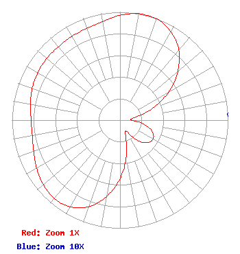
| Antenna Data for Antenna Id: 1010528 KPBS DT File: -0000212277 DIELECTRIC - TFU-18GTH/VP-R C170SP Service: DT Standard Pattern: N |  | |||||||||||||||||||||
| Azimuth | Ratio | Azimuth | Ratio | Azimuth | Ratio | Azimuth | Ratio | |||||||||||||||
| 0 | 0.970 | 10 | 1.000 | 20 | 0.998 | 30 | 0.943 | |||||||||||||||
| 40 | 0.848 | 50 | 0.698 | 60 | 0.521 | 70 | 0.323 | |||||||||||||||
| 80 | 0.137 | 90 | 0.107 | 100 | 0.232 | 110 | 0.320 | |||||||||||||||
| 120 | 0.352 | 130 | 0.325 | 140 | 0.239 | 150 | 0.120 | |||||||||||||||
| 160 | 0.150 | 170 | 0.340 | 180 | 0.540 | 190 | 0.718 | |||||||||||||||
| 200 | 0.852 | 210 | 0.925 | 220 | 0.946 | 230 | 0.928 | |||||||||||||||
| 240 | 0.892 | 250 | 0.850 | 260 | 0.825 | 270 | 0.823 | |||||||||||||||
| 280 | 0.843 | 290 | 0.865 | 300 | 0.879 | 310 | 0.887 | |||||||||||||||
| 320 | 0.886 | 330 | 0.893 | 340 | 0.902 | 350 | 0.928 | |||||||||||||||
Structure Registration Number 1213483 Structure Type: LTOWER Registered To: SAN DIEGO STATE UNIVERSITY DBA KPBS Structure Address: Atop Mt San Miguel San Diego, CA County Name: San Diego County ASR Issued: 05/20/2024 Date Built: 05/17/2019 Site Elevation: 760.5 m (2495 ft.) Structure Height: 45.7 m (150 ft.) Height Overall: 58.5 m (192 ft.) Overall Height AMSL: 819 m (2687 ft.) FAA Determination: 09/19/2018 FAA Study #: 2018-AWP-12019-OE Paint & Light FAA Chapters: NONE Removed expiration date from determination. Scenario 1./jjs/case#635066 32-41-52.7 N 116-56-06.3 W (NAD 83) 32-41-52.5 N 116-56-03.2 W (Converted to NAD 27) |
5200 Campanile Drive San Diego, CA 92182 Phone: 619-594-1515 Government Entity | Title: Director of Engineering Date: 03/09/2023 Application Certifier Board of Trustees, California State University for San Diego State University 5200 Campanile Drive San Diego, CA 92182 Applicant Leon Messenie KPBS 5200 Campanile Drive San Diego, CA 92182 Director of Engineering, KPBS Barry S. Persh Gray Miller Persh LLP 2233 Wisconsin Ave., NW Suite 226 Washington, DC 20007 | ||||||||||||||||||||
|
| |||||||||||||||||||||