FCCInfo.com
A Service of Cavell, Mertz & Associates, Inc.
(855) FCC-INFO
|
|
WNIT-TV from 01/24/1980 WNIT from ??? |
Virtual Channel 34 |
|
||||||||||||||||||||||
|
|
Status: LIC Application Accepted: 05/23/2023 License Expires: 08/01/2029 File Number: 0000215059 FCC Website Links: LMS Facility Details This Application Other WNIT Applications Including Superseded Applications Service Contour - Open Street Map or USGS Map (41 dBu) Service Contour - KML / Google Earth (41 dBu) Public Inspection Files Rabbit Ears Info Search for WNIT Site Location: 41-36-49.2 N 86-11-20.0 W (NAD 83) Site Location: 41-36-49.0 N 86-11-20.0 W (Converted to NAD 27) ERP: 78.3 kW Polarization: Horizontally polarized HAAT: 332.9 m (1092 ft.) Electrical Beam Tilt: 0.6 degrees R/C AGL: 308 m (1010 ft.) R/C AMSL: 574.7 m (1885 ft.) Site Elevation: 266.7 m. (875 ft.) Height Overall*: 317.6 m (1042 ft.) (* As Filed In This Application, may differ from ASR Data, Below.) Directional Antenna - Antenna Make/Model: DIELECTRIC TUA-O4-14/56H-1-T Antenna ID: 1010733 Polarization: Horizontally polarized | ||||||||||||||||||||||||
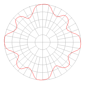
| Antenna Data for Antenna Id: 1010733 WNIT DT File: -0000215059 DIELECTRIC - TUA-O4-14/56H-1-T Service: DT Standard Pattern: N |  | ||||||||||||||||||||||||
| Azimuth | Ratio | Azimuth | Ratio | Azimuth | Ratio | Azimuth | Ratio | ||||||||||||||||||
| 0 | 0.997 | 5 | 1.000 | 10 | 0.979 | 20 | 0.818 | ||||||||||||||||||
| 30 | 0.774 | 40 | 0.913 | 50 | 0.881 | 60 | 0.724 | ||||||||||||||||||
| 70 | 0.787 | 80 | 0.955 | 90 | 0.997 | 95 | 1.000 | ||||||||||||||||||
| 100 | 0.979 | 110 | 0.818 | 120 | 0.774 | 130 | 0.913 | ||||||||||||||||||
| 140 | 0.881 | 150 | 0.724 | 160 | 0.787 | 170 | 0.955 | ||||||||||||||||||
| 180 | 0.997 | 185 | 1.000 | 190 | 0.979 | 200 | 0.818 | ||||||||||||||||||
| 210 | 0.774 | 220 | 0.913 | 230 | 0.881 | 240 | 0.724 | ||||||||||||||||||
| 250 | 0.787 | 260 | 0.955 | 270 | 0.997 | 275 | 1.000 | ||||||||||||||||||
| 280 | 0.979 | 290 | 0.818 | 300 | 0.774 | 310 | 0.913 | ||||||||||||||||||
| 320 | 0.881 | 330 | 0.724 | 340 | 0.787 | 350 | 0.955 | ||||||||||||||||||
Structure Registration Number 1237678 Structure Type: GTOWER Registered To: Charles S. Hayes Inc Structure Address: 0.9 Kilometers Northeast Of Intersection Of Hickory & Kern Roads South Bend, IN County Name: St. Joseph County ASR Issued: 02/16/2016 Date Built: 04/12/2003 Site Elevation: 266.7 m (875 ft.) Structure Height: 316.7 m (1039 ft.) Height Overall: 317.6 m (1042 ft.) Overall Height AMSL: 584.3 m (1917 ft.) FAA Determination: 11/08/2013 FAA Study #: 2013-AGL-10291-OE FAA Circular #: 70/7460-1K Paint & Light FAA Chapters: 3, 4, 5, 12 PRIOR STUDY 2003-AGL-2368-OE 41-36-49.2 N 86-11-20.0 W (NAD 83) 41-36-49.0 N 86-11-20.0 W (Converted to NAD 27) |
P.O. Box 7034 South Bend, IN 46634 Phone: 574-675-9648 Not-for-Profit | Title: President and General Manager Date: 05/23/2023 Application Certifier Michiana Public Broadcasting Corporation P.O. Box 7034 South Bend, IN 46634 Applicant Derek Teslik Gray Miller Persh LLP 2233 Wisconsin Ave., NW, Ste. 226 Washington, DC 20007 Brian L. Hoover Michiana Public Broadcasting Corporation P.O. Box 7034 South Bend, IN 46634 Employee | |||||||||||||||||||||||
| |||||||||||||||||||||||||