
FCCInfo.com
A Service of Cavell, Mertz & Associates, Inc.
(855) FCC-INFO
|
|
KUTF from 04/29/2005 KUTF from 03/31/2005 KUTF from 12/17/2004 KUTF from 06/09/2000 |
Virtual Channel 12 |
|
||||||||||||||||
|
|
Status: APP Application Accepted: 05/30/2024 File Number: 0000245332 FCC Website Links: LMS Facility Details This Application Other KUTF Applications Including Superseded Applications Mailing Address Correspondence for KUTF Correspondence related to application 0000245332 Service Contour - Open Street Map or USGS Map (36 dBu) Service Contour - KML / Google Earth (36 dBu) Public Inspection Files Rabbit Ears Info Search for KUTF Site Location: 41-47-02.7 N 112-13-57.8 W (NAD 83) Site Location: 41-47-03.0 N 112-13-55.0 W (Converted to NAD 27) ERP: 22.3 kW Polarization: Circularly polarized HAAT: 690 m (2264 ft.) R/C AGL: 85 m (279 ft.) R/C AMSL: 2175.6 m (7138 ft.) Site Elevation: 2090.6 m. (6859 ft.) Height Overall*: 93 m (305 ft.) (* As Filed In This Application, may differ from ASR Data, Below.) Directional Antenna - Antenna Make/Model: Systems With Reliability Inc. SWCVL6EC/12-CP Antenna ID: 1011723 Polarization: Circularly polarized | ||||||||||||||||||
| Antenna Data for Antenna Id: 1011723 KUTF DT File: -0000245332 Systems With Reliability Inc. - SWCVL6EC/12-CP Service: DT Standard Pattern: N Pattern and Field Values Include a 90° Clockwise Rotation | 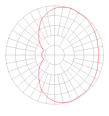 | ||||||||||||||||||
| Azimuth | Ratio | Azimuth | Ratio | Azimuth | Ratio | Azimuth | Ratio | ||||||||||||
| 0 | 0.940 | 10 | 0.980 | 20 | 1.000 | 30 | 0.980 | ||||||||||||
| 40 | 0.980 | 50 | 0.960 | 60 | 0.940 | 70 | 0.920 | ||||||||||||
| 80 | 0.900 | 90 | 0.900 | 100 | 0.900 | 110 | 0.920 | ||||||||||||
| 120 | 0.940 | 130 | 0.960 | 140 | 0.980 | 150 | 0.980 | ||||||||||||
| 160 | 1.000 | 170 | 0.980 | 180 | 0.940 | 190 | 0.860 | ||||||||||||
| 200 | 0.760 | 210 | 0.620 | 220 | 0.500 | 230 | 0.400 | ||||||||||||
| 240 | 0.300 | 250 | 0.240 | 260 | 0.260 | 270 | 0.260 | ||||||||||||
| 280 | 0.260 | 290 | 0.240 | 300 | 0.300 | 310 | 0.400 | ||||||||||||
| 320 | 0.500 | 330 | 0.620 | 340 | 0.760 | 350 | 0.860 | ||||||||||||
Structure Registration Number 1234946 Structure Type: TOWER Registered To: Teton Communications Inc. Structure Address: Cal Mountain Tremonton, UT County Name: Box Elder County ASR Issued: 03/26/2024 Date Built: 07/26/2002 Site Elevation: 2090.6 m (6859 ft.) Structure Height: 93 m (305 ft.) Height Overall: 93 m (305 ft.) Overall Height AMSL: 2183.6 m (7164 ft.) FAA Determination: 07/09/2002 FAA Study #: 2002-ANM-1213-OE FAA Circular #: 70/7460-1K Paint & Light FAA Chapters: 4, 8, 12 Removed expiration date from determination. Scenario 1./jjs/case#635066 41-47-02.7 N 112-13-57.8 W (NAD 83) 41-47-03.0 N 112-13-55.0 W (Converted to NAD 27) |
3901 Highway 121 South Bedford, TX 76021 Phone: 817-571-1229 Not-for-Profit | Title: Manager Date: 05/30/2024 Application Certifier Word of God Fellowship, Inc. 3901 Highway 121 South Bedford, TX 76021 Applicant Richard Goetz R & L Media Systems 135 N Country Club Dr Hendersonville, PA 37075 Mark Denbo Smithwick & Belendiuk, P.C. 5028 Wisconsin Avenue, N.W. Suite 301 Washington, DC 20016 Counsel | |||||||||||||||||