
FCCInfo.com
A Service of Cavell, Mertz & Associates, Inc.
(855) FCC-INFO
|
|
W50CO from 01/14/1994 |
|
|
||||||||||||||||
|
|
Status: CP (Licensed And Silent) Application Accepted: 06/06/2024 W50CO CP Expires: 08/01/2024 File Number: 0000245880 FCC Website Links: LMS Facility Details This Application Other W50CO Applications Including Superseded Applications Mailing Address Correspondence for W50CO Correspondence related to application 0000245880 Service Contour - Open Street Map or USGS Map (51 dBu) Service Contour - KML / Google Earth (51 dBu) Rabbit Ears Info Search for W50CO Site Location: 30-18-48.0 N 81-38-58.0 W (NAD 83) Site Location: 30-18-47.1 N 81-38-58.7 W (Converted to NAD 27) ERP: 15 kW Polarization: Elliptically polarized Electrical Beam Tilt: 3.0 degrees R/C AGL: 122 m (400 ft.) R/C AMSL: 123 m (404 ft.) Emission Mask: Full Service Site Elevation: 1 m. (3 ft.) Height Overall*: 151.6 m (497 ft.) (* As Filed In This Application, may differ from ASR Data, Below.) Directional Antenna - Antenna Make/Model: DIELECTRIC TUL-P4 6/18-M-1-K Antenna ID: 1011751 Polarization: Elliptically polarized | ||||||||||||||||||
| Antenna Data for Antenna Id: 1011751 W50CO LD File: -0000245880 DIELECTRIC - TUL-P4 6/18-M-1-K Service: LD Standard Pattern: N | 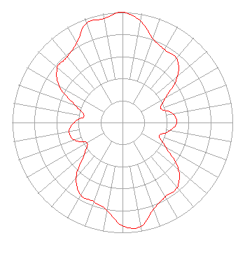 | ||||||||||||||||||
| Azimuth | Ratio | Azimuth | Ratio | Azimuth | Ratio | Azimuth | Ratio | ||||||||||||
| 0 | 1.000 | 10 | 0.936 | 20 | 0.809 | 30 | 0.763 | ||||||||||||
| 40 | 0.761 | 50 | 0.653 | 60 | 0.454 | 70 | 0.371 | ||||||||||||
| 80 | 0.464 | 90 | 0.492 | 100 | 0.438 | 110 | 0.354 | ||||||||||||
| 120 | 0.457 | 130 | 0.663 | 140 | 0.771 | 150 | 0.779 | ||||||||||||
| 160 | 0.832 | 170 | 0.958 | 180 | 0.936 | 190 | 0.809 | ||||||||||||
| 200 | 0.763 | 210 | 0.761 | 220 | 0.653 | 230 | 0.454 | ||||||||||||
| 240 | 0.371 | 250 | 0.464 | 260 | 0.492 | 270 | 0.438 | ||||||||||||
| 280 | 0.354 | 290 | 0.457 | 300 | 0.663 | 310 | 0.771 | ||||||||||||
| 320 | 0.779 | 330 | 0.832 | 340 | 0.958 | 350 | 0.958 | ||||||||||||
Structure Registration Number 1017605 Structure Type: Registered To: Graham Media Group, Florida, Inc. Structure Address: 1851 Southampton Road Jacksonville, FL County Name: Duval County ASR Issued: 03/13/2019 Date Built: 01/01/1988 Site Elevation: 1 m (3 ft.) Structure Height: 125.4 m (411 ft.) Height Overall: 151.6 m (497 ft.) Overall Height AMSL: 152.6 m (501 ft.) FAA Determination: 01/10/1989 FAA Study #: 89-ASO-45-OE Paint & Light FAA Chapters: 1, 3, 4, 13, 21 RED LIGHTS/PAINT 30-18-48.0 N 81-38-58.0 W (NAD 83) 30-18-47.1 N 81-38-58.7 W (Converted to NAD 27) |
Hurst, TX 76054 Phone: 214-770-7770 Corporation | Title: Ceo Date: 06/06/2024 Application Certifier EDGE SPECTRUM, INC. Edge Spectrum, Inc. Hurst, TX 76054 Applicant Susan Hansen B. W. St. Clair 2305 Vida Shaw Rd. New Iberia, LA 70563 Consultant Ari Meltzer Wiley Rein Llp 2050 M Street, Nw Washington, DC 20036 Caleb Weiss Ark Multicasting, Inc. Cedar Hill, TX 75106 President Randy Weiss Edge Spectrum, Inc. Hurst, TX 76054 CEO Josh Weiss Ark Multicasting, Inc. Cedar Hill, TX 75106 CEO | |||||||||||||||||