
FCCInfo.com
A Service of Cavell, Mertz & Associates, Inc.
(855) FCC-INFO
|
|
|
|
|
||||||||||||||||
|
|
W280FN Channel: 256D 99.1 MHz Ashland City, Tennessee Service: FX - A translator or application for a translator. Facility ID: 200720 Fac. Service: FX Programming Delivery Method: Unspecified Status: CP Application Accepted: 06/21/2024 Application Pending: 06/21/2024 File Number: 0000246760 W280FN CP Expires: 12/02/2025 Application Type: Minor Modification FCC Website Links: LMS Facility Details This Application Other W280FN Applications Other W280FN Applications in CDBS Including Superseded Applications Mailing Address Correspondence for W280FN Correspondence related to application 0000246760 Service Contour - Open Street Map or USGS Map (60 dBu) Service Contour - KML / Google Earth (60 dBu) Facility Type: FM STATION Class: D, A Noncommercial educational operating with no more than 10W Site Location: 36-02-59.0 N 86-49-59.0 W (NAD 83) Site Location: 36-02-58.8 N 86-49-59.0 W (Converted to NAD 27) Effective Radiated Power: 0.25 kW Antenna Center HAAT: 0 m Antenna Center AMSL: 396.1 m Horiz.; 398.1 m Vert. (1300 ft. Horiz. / 1306 ft. Vert.) Antenna Center HAG: 70 m Horiz.; 72 m Vert. (230 ft. Horiz. / 236 ft. Vert.) Site Elevation: 326.1 m. (1070 ft.) Height Overall*: 95.1 m (312 ft.) (* As Filed In This Application, may differ from ASR Data, Below.) Directional Antenna Antenna Make/Model: NICOM BKY-3P-2 Antenna ID: 1010245 Polarization: H
| ||||||||||||||||||
| Antenna Data for Antenna Id: 1010245 W280FN FX File: -0000246760 NICOM - BKY-3P-2 Service: FX | 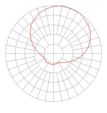 | ||||||||||||||||||
| Azimuth | Ratio | Azimuth | Ratio | Azimuth | Ratio | Azimuth | Ratio | ||||||||||||
| 0 | 0.970 | 10 | 1.000 | 20 | 1.000 | 30 | 1.000 | ||||||||||||
| 40 | 0.970 | 50 | 0.930 | 60 | 0.880 | 70 | 0.810 | ||||||||||||
| 80 | 0.730 | 90 | 0.630 | 100 | 0.530 | 110 | 0.440 | ||||||||||||
| 120 | 0.360 | 130 | 0.290 | 140 | 0.250 | 150 | 0.220 | ||||||||||||
| 160 | 0.220 | 170 | 0.220 | 180 | 0.230 | 190 | 0.230 | ||||||||||||
| 200 | 0.230 | 210 | 0.230 | 220 | 0.230 | 230 | 0.220 | ||||||||||||
| 240 | 0.220 | 250 | 0.220 | 260 | 0.250 | 270 | 0.290 | ||||||||||||
| 280 | 0.360 | 290 | 0.440 | 300 | 0.530 | 310 | 0.630 | ||||||||||||
| 320 | 0.730 | 330 | 0.810 | 340 | 0.880 | 350 | 0.930 | ||||||||||||
Structure Registration Number 1043960 Structure Type: GTOWER Registered To: Pinnacle Towers LLC Structure Address: .5 Mi. N Of Old Hickory Blvd. Wnge Hill Brentwood, TN County Name: Davidson County ASR Issued: 05/06/2016 Date Built: 01/01/1974 Site Elevation: 326.1 m (1070 ft.) Structure Height: 91.7 m (301 ft.) Height Overall: 95.1 m (312 ft.) Overall Height AMSL: 421.2 m (1382 ft.) FAA Determination: 10/29/2012 FAA Study #: 2012-ASO-10119-OE FAA Circular #: 70/7460-1K Paint & Light FAA Chapters: 4, 6, 12 PRIOR STUDY 2009-ASO-6635-OE 36-02-59.0 N 86-49-59.0 W (NAD 83) 36-02-58.8 N 86-49-59.0 W (Converted to NAD 27) |
2631b Nolensville Pike Nashville, TN 37111 Phone: 615-844-1039 Corporation | Title: President Date: 06/21/2024 Application Certifier WCHQ The Mighty Seven Ninety Incorporated 2631b Nolensville Pike Nashville, TN 37111 Applicant Jim Turvaville Turbo Tech Services 360 Patton Street - Po Box 144 Mobeetie, TX 79061 Consulting Engineer | |||||||||||||||||