
FCCInfo.com
A Service of Cavell, Mertz & Associates, Inc.
(855) FCC-INFO
|
|
|
|
|
||||||||||||||||
|
|
Status: CP Application Accepted: 07/16/2024 W10DG-D CP Expires: 07/17/2027 File Number: 0000248965 FCC Website Links: LMS Facility Details This Application Other W10DG-D Applications Including Superseded Applications Mailing Address Correspondence for W10DG-D Correspondence related to application 0000248965 Service Contour - Open Street Map or USGS Map (48 dBu) Service Contour - KML / Google Earth (48 dBu) Rabbit Ears Info Search for W10DG-D Site Location: 37-59-18.9 N 87-35-41.1 W (NAD 83) Site Location: 37-59-18.7 N 87-35-41.0 W (Converted to NAD 27) ERP: 1 kW Polarization: Horizontally polarized R/C AGL: 74.4 m (244 ft.) R/C AMSL: 210 m (689 ft.) Emission Mask: Full Service Site Elevation: 135.6 m. (445 ft.) Height Overall*: 118.5 m (389 ft.) (* As Filed In This Application, may differ from ASR Data, Below.) Directional Antenna - Antenna Make/Model: Propagation System Inc PSILPBQM Antenna ID: 96306 Polarization: Horizontally polarized | ||||||||||||||||||
| Antenna Data for Antenna Id: 96306 W10DG-D LD File: -0000248965 Propagation System Inc - PSILPBQM Service: LD Standard Pattern: Y Pattern and Field Values Include a 145° Clockwise Rotation | 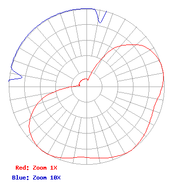 | ||||||||||||||||||
| Azimuth | Ratio | Azimuth | Ratio | Azimuth | Ratio | Azimuth | Ratio | ||||||||||||
| 5 | 0.100 | 15 | 0.100 | 25 | 0.300 | 35 | 0.590 | ||||||||||||
| 45 | 0.760 | 55 | 0.900 | 65 | 0.970 | 75 | 1.000 | ||||||||||||
| 85 | 0.990 | 95 | 0.950 | 105 | 0.910 | 115 | 0.920 | ||||||||||||
| 125 | 0.950 | 135 | 0.980 | 145 | 1.000 | 155 | 0.980 | ||||||||||||
| 165 | 0.950 | 175 | 0.920 | 185 | 0.910 | 195 | 0.950 | ||||||||||||
| 205 | 0.990 | 215 | 1.000 | 225 | 0.970 | 235 | 0.900 | ||||||||||||
| 245 | 0.760 | 255 | 0.580 | 265 | 0.300 | 275 | 0.100 | ||||||||||||
| 285 | 0.100 | 295 | 0.100 | 305 | 0.100 | 315 | 0.100 | ||||||||||||
| 325 | 0.100 | 335 | 0.100 | 345 | 0.100 | 355 | 0.100 | ||||||||||||
Structure Registration Number 1030625 Structure Type: GTOWER Registered To: Gray Local Media, Inc. Structure Address: 1115 Mount Auburn Rd Evansville, IN County Name: Vanderburgh County ASR Issued: 08/26/2024 Date Built: 01/03/2013 Site Elevation: 135.6 m (445 ft.) Structure Height: 117.6 m (386 ft.) Height Overall: 118.5 m (389 ft.) Overall Height AMSL: 254.1 m (834 ft.) FAA Determination: 11/23/2012 FAA Study #: 2012-AGL-8830-OE Paint & Light FAA Chapters: 1, 3, 12, 21 Continue As Is OM&L = PAINT/RED LIGHTS 37-59-18.9 N 87-35-41.1 W (NAD 83) 37-59-18.7 N 87-35-41.0 W (Converted to NAD 27) |
9925 Haynes Bridge Rd Suite 200-155 Alpharetta, GA 30022 Phone: 470-413-1820 Limited Liability Company | Title: Member/Manager Date: 07/16/2024 Application Certifier Castelli Media, LLC 9925 Haynes Bridge Rd Suite 200-155 Alpharetta, GA 30022 Applicant Susan Hansen B. W. St. Clair 2305 Vida Shaw Road New Iberia, LA 70563 Consultant | |||||||||||||||||