FCCInfo.com
A Service of Cavell, Mertz & Associates, Inc.
(855) FCC-INFO
|
|
WLNY from 09/01/1996 WLIG from 11/09/1982 790813KG from ??? |
Virtual Channel 55 |  |
|
|||||||||||||||||
|
|
Status: LIC Application Accepted: 10/15/2024 License Expires: 06/01/2031 File Number: 0000255759 FCC Website Links: LMS Facility Details This Application Other WLNY-TV Applications Including Superseded Applications Service Contour - Open Street Map or USGS Map (41 dBu) Service Contour - KML / Google Earth (41 dBu) Public Inspection Files Rabbit Ears Info Search for WLNY-TV Site Location: 40-53-50.1 N 72-54-54.6 W (NAD 83) Site Location: 40-53-49.7 N 72-54-56.2 W (Converted to NAD 27) ERP: 1000 kW Polarization: Circularly polarized HAAT: 193.9 m (636 ft.) Electrical Beam Tilt: 0.75 degrees R/C AGL: 189 m (620 ft.) R/C AMSL: 216.4 m (710 ft.) Site Elevation: 27.4 m. (90 ft.) Height Overall*: 195.7 m (642 ft.) (* As Filed In This Application, may differ from ASR Data, Below.) Directional Antenna - Antenna Make/Model: Jampro JSM-16/D29 TCCP Antenna ID: 1012202 Polarization: Circularly polarized | ||||||||||||||||||||
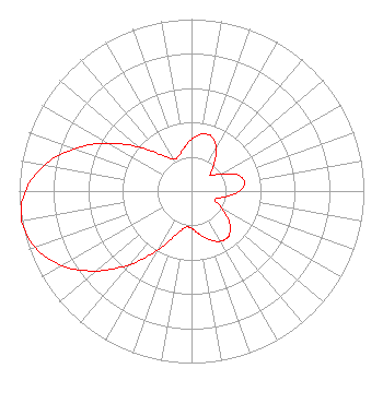
| Antenna Data for Antenna Id: 1012202 WLNY-TV DT File: -0000255759 Jampro - JSM-16/D29 TCCP Service: DT Standard Pattern: N |  | ||||||||||||||||||||
| Azimuth | Ratio | Azimuth | Ratio | Azimuth | Ratio | Azimuth | Ratio | ||||||||||||||
| 0 | 0.301 | 10 | 0.337 | 15 | 0.342 | 20 | 0.337 | ||||||||||||||
| 30 | 0.289 | 40 | 0.203 | 50 | 0.142 | 60 | 0.197 | ||||||||||||||
| 70 | 0.279 | 80 | 0.313 | 90 | 0.279 | 100 | 0.197 | ||||||||||||||
| 110 | 0.142 | 120 | 0.203 | 130 | 0.289 | 140 | 0.337 | ||||||||||||||
| 145 | 0.342 | 150 | 0.337 | 160 | 0.301 | 170 | 0.254 | ||||||||||||||
| 180 | 0.217 | 190 | 0.215 | 200 | 0.276 | 210 | 0.399 | ||||||||||||||
| 220 | 0.557 | 230 | 0.723 | 240 | 0.867 | 250 | 0.965 | ||||||||||||||
| 260 | 1.000 | 270 | 0.965 | 280 | 0.867 | 290 | 0.723 | ||||||||||||||
| 300 | 0.557 | 310 | 0.399 | 320 | 0.276 | 330 | 0.215 | ||||||||||||||
| 340 | 0.217 | 350 | 0.254 | ||||||||||||||||||
Structure Registration Number 1006717 Structure Type: GTOWER Registered To: CBS Communications Services Inc. Structure Address: 1.1 Km Nne Of Int Of Wading River Hollow Road & Route 25 Brookhaven Town, NY County Name: Suffolk County ASR Issued: 10/03/2024 Date Built: 01/01/1985 Site Elevation: 27.4 m (90 ft.) Structure Height: 183.9 m (603 ft.) Height Overall: 195.7 m (642 ft.) Overall Height AMSL: 223.1 m (732 ft.) FAA Determination: 12/27/2023 FAA Study #: 2023-AEA-9173-OE FAA Circular #: 70/7460-1K Paint & Light FAA Chapters: 4, 7, 12 OM&L to remain the same as prior studies = 24-HR HI-STROBES 40-53-50.1 N 72-54-54.6 W (NAD 83) 40-53-49.7 N 72-54-56.2 W (Converted to NAD 27) |
1275 Pennsylvania Ave. NW Suite 710 - Licensing Dept. Washington, DC 20004 Phone: 202-457-4505 Limited Liability Company | Title: VP, Government Relations and Regulatory Date: 10/15/2024 Application Certifier CBS LITV LLC CBS LITV LLC 1275 Pennsylvania Ave. NW Suite 710 - Licensing Dept. Washington, DC 20004 Applicant John Bagwell Paramount Global 1515 Broadway New York, NY 10036 SVP and Associate General Counsel Joseph M. Davis, P.E. Chesapeake RF Consultants, LLC 207 Old Dominion Road Yorktown, VA 23692 Consulting Engineer Daniel G. Ryson Paramount Global 1275 Pennsylvania Ave. NW Suite 710 - Licensing Dept. Washington, DC 20004 Director Spectrum Management | |||||||||||||||||||