FCCInfo.com
A Service of Cavell, Mertz & Associates, Inc.
(855) FCC-INFO
|
|
KVDF-CA from 06/28/2004 K31EX from 09/06/1996 K69GP from 09/06/1996 910430BH from ??? |
Virtual Channel 31 |
|
||||||||||||||||||
|
|
Status: LIC Application Accepted: 05/15/2015 License Expires: 08/01/2030 File Number: 0000001489 FCC Website Links: LMS Facility Details This Application Other KVDF-CD Applications Including Superseded Applications Service Contour - Open Street Map or USGS Map (51 dBu) Service Contour - KML / Google Earth (51 dBu) Public Inspection Files Rabbit Ears Info Search for KVDF-CD Site Location: 29-26-29.9 N 98-30-22.8 W (NAD 83) Site Location: 29-26-29.1 N 98-30-21.7 W (Converted to NAD 27) ERP: 15 kW Polarization: Horizontally polarized Electrical Beam Tilt: 0.5 degrees R/C AGL: 142.8 m (469 ft.) R/C AMSL: 350.0 m (1148 ft.) Emission Mask: Simple Site Elevation: 207.2 m. (680 ft.) Height Overall*: 152 m (499 ft.) (* As Filed In This Application, may differ from ASR Data, Below.) Directional Antenna - Antenna Make/Model: Systems With Reliability Inc. SWLP16EC/31 Antenna ID: 106327 Polarization: Horizontally polarized | ||||||||||||||||||||
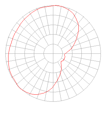
| Antenna Data for Antenna Id: 106327 KVDF-CD DC File: -0000001489 Systems With Reliability Inc. - SWLP16EC/31 Service: DC Standard Pattern: Y Pattern and Field Values Include a 295° Clockwise Rotation |  | ||||||||||||||||||||
| Azimuth | Ratio | Azimuth | Ratio | Azimuth | Ratio | Azimuth | Ratio | ||||||||||||||
| 5 | 1.000 | 15 | 0.980 | 25 | 0.940 | 35 | 0.860 | ||||||||||||||
| 45 | 0.760 | 55 | 0.620 | 65 | 0.500 | 75 | 0.400 | ||||||||||||||
| 85 | 0.300 | 95 | 0.240 | 105 | 0.260 | 115 | 0.260 | ||||||||||||||
| 125 | 0.260 | 135 | 0.240 | 145 | 0.300 | 155 | 0.400 | ||||||||||||||
| 165 | 0.500 | 175 | 0.620 | 185 | 0.760 | 195 | 0.860 | ||||||||||||||
| 205 | 0.940 | 215 | 0.980 | 225 | 1.000 | 235 | 0.980 | ||||||||||||||
| 245 | 0.980 | 255 | 0.960 | 265 | 0.940 | 275 | 0.920 | ||||||||||||||
| 285 | 0.900 | 295 | 0.900 | 305 | 0.900 | 315 | 0.920 | ||||||||||||||
| 325 | 0.940 | 335 | 0.960 | 345 | 0.980 | 355 | 0.980 | ||||||||||||||
Structure Registration Number 1214327 Structure Type: GTOWER Registered To: American Towers LLC Structure Address: 1010 W. Laurel St. (atc Site # 282679) San Antonio, TX County Name: Bexar County ASR Issued: 05/24/2016 Date Built: 07/12/2001 Site Elevation: 207.2 m (680 ft.) Structure Height: 152 m (499 ft.) Height Overall: 152 m (499 ft.) Overall Height AMSL: 359.2 m (1178 ft.) FAA Determination: 03/16/2016 FAA Study #: 2016-ASW-2905-OE FAA Circular #: 70/7460-1L Paint & Light FAA Chapters: 4, 8, 12 PRIOR STUDY 2000-ASW-1251-OE 29-26-29.9 N 98-30-22.8 W (NAD 83) 29-26-29.1 N 98-30-21.7 W (Converted to NAD 27) |
295 Madison Avenue, 12th Floor New York, NY 10017 Phone: 954-606-5486 Corporation | Title: Managing Member of Sole Owner Date: 05/15/2015 Application Certifier Northstar San Antonio License, LLC. Northstar San Antonio License, LLC. 1701 N. Market Street Suite 500 Dallas, TX 75202 Applicant Jack N. Goodman, Esq Law Offices of Jack N. Goodman 1200 New Hampshire Avenue, NW Suite 600 Washington, DC 20036 | |||||||||||||||||||