FCCInfo.com
A Service of Cavell, Mertz & Associates, Inc.
(855) FCC-INFO
|
|
WEMW-CD from 06/03/2010 WEMW-LD from 05/27/2010 WEMW-LP from 09/08/2005 W56CG from 01/29/1998 DW56CG from 02/20/1997 W56CG from 11/22/1988 JB0702SG from ??? |
Virtual Channel 56 |
|
||||||||||||||||
|
|
Status: LIC Application Accepted: 07/21/2017 License Expires: 08/01/2023 File Number: 0000029024 FCC Website Links: LMS Facility Details This Application Other DWEMW-CD Applications Including Superseded Applications Service Contour - Open Street Map or USGS Map (51 dBu) Service Contour - KML / Google Earth (51 dBu) Public Inspection Files Rabbit Ears Info Search for DWEMW-CD Site Location: 40-18-51.0 N 79-34-02.0 W (NAD 83) Site Location: 40-18-50.8 N 79-34-02.9 W (Converted to NAD 27) ERP: 12 kW Electrical Beam Tilt: -0.5 degrees R/C AGL: 63.3 m (208 ft.) R/C AMSL: 453.4 m (1488 ft.) Emission Mask: Full Service Site Elevation: 390.1 m. (1280 ft.) Height Overall*: 76.2 m (250 ft.) (* As Filed In This Application, may differ from ASR Data, Below.) Directional Antenna - Antenna Make/Model: Systems With Reliability Inc. LP12/19 Antenna ID: 117146 | ||||||||||||||||||
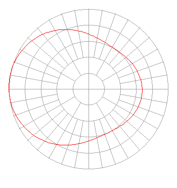
| Antenna Data for Antenna Id: 117146 DWEMW-CD DC File: -0000029024 Systems With Reliability Inc. - LP12/19 Service: DC Standard Pattern: Y Pattern and Field Values Include a 275° Clockwise Rotation |  | ||||||||||||||||||
| Azimuth | Ratio | Azimuth | Ratio | Azimuth | Ratio | Azimuth | Ratio | ||||||||||||
| 5 | 0.664 | 15 | 0.629 | 25 | 0.607 | 35 | 0.601 | ||||||||||||
| 45 | 0.608 | 55 | 0.624 | 65 | 0.643 | 75 | 0.656 | ||||||||||||
| 85 | 0.671 | 95 | 0.675 | 105 | 0.670 | 115 | 0.657 | ||||||||||||
| 125 | 0.639 | 135 | 0.620 | 145 | 0.605 | 155 | 0.601 | ||||||||||||
| 165 | 0.610 | 175 | 0.635 | 185 | 0.673 | 195 | 0.721 | ||||||||||||
| 205 | 0.774 | 215 | 0.827 | 225 | 0.877 | 235 | 0.920 | ||||||||||||
| 245 | 0.955 | 255 | 0.981 | 265 | 0.996 | 275 | 1.000 | ||||||||||||
| 285 | 0.994 | 295 | 0.976 | 305 | 0.949 | 315 | 0.912 | ||||||||||||
| 325 | 0.867 | 335 | 0.817 | 345 | 0.763 | 355 | 0.711 | ||||||||||||
Structure Registration Number 1036277 Structure Type: Registered To: Comcast of Pennsylvania, LLC Structure Address: Mount Thor Rd Greensburg, PA County Name: Westmoreland County ASR Issued: 07/02/2021 Date Built: 01/01/1997 Site Elevation: 390.1 m (1280 ft.) Structure Height: 75.3 m (247 ft.) Height Overall: 76.2 m (250 ft.) Overall Height AMSL: 466.3 m (1530 ft.) FAA Determination: 11/12/1997 FAA Study #: 97-AEA-3156-OE FAA Circular #: 70/7460-1J Paint & Light FAA Chapters: 4, 8, 13 40-18-51.0 N 79-34-02.0 W (NAD 83) 40-18-50.8 N 79-34-02.9 W (Converted to NAD 27) |
11710 Plaza America Drive Suite 2000 Reston, VA 20190 Phone: 703-364-5300 Limited Liability Company | Title: President Date: 07/21/2017 Application Certifier OTA Broadcasting (PIT), LLC 11710 Plaza America Drive Suite 2000 Reston, VA 20190 Applicant Patricia M. Chuh Wilkinson Barker Knauer, LLP 1800 M Street NW Suite 800N Washington, DC 20036 | |||||||||||||||||