FCCInfo.com
A Service of Cavell, Mertz & Associates, Inc.
(855) FCC-INFO
|
|
WOCH-CD from 05/23/2014 WOCH-CA from 12/29/2005 WOCH-LP from 02/01/2000 W04CK from 09/27/1989 JC0624RP from ??? |
Virtual Channel 41 |
|
||||||||||||||||
|
|
Status: LIC Application Accepted: 08/14/2017 License Expires: 12/01/2021 File Number: 0000029269 FCC Website Links: LMS Facility Details This Application Other DWOCH-CD Applications Including Superseded Applications Service Contour - Open Street Map or USGS Map (51 dBu) Service Contour - KML / Google Earth (51 dBu) Public Inspection Files Rabbit Ears Info Search for DWOCH-CD Site Location: 41-53-56.1 N 87-37-23.2 W (NAD 83) Site Location: 41-53-56.0 N 87-37-23.0 W (Converted to NAD 27) ERP: 15 kW Electrical Beam Tilt: 2 degrees R/C AGL: 355.7 m (1167 ft.) R/C AMSL: 536.4 m (1760 ft.) Emission Mask: Stringent Site Elevation: 180.7 m. (593 ft.) Height Overall*: 459 m (1506 ft.) (* As Filed In This Application, may differ from ASR Data, Below.) Directional Antenna - Antenna Make/Model: Propagation System Inc CUS-WOCH Antenna ID: 98910 | ||||||||||||||||||
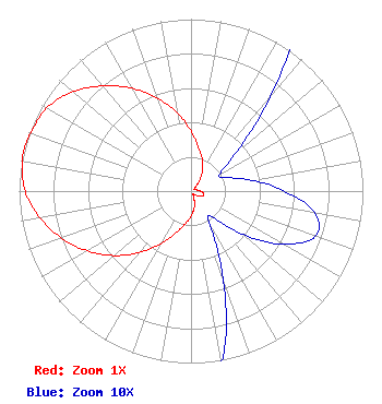
| Antenna Data for Antenna Id: 98910 DWOCH-CD DC File: -0000029269 Propagation System Inc - CUS-WOCH Service: DC Standard Pattern: Y |  | ||||||||||||||||||
| Azimuth | Ratio | Azimuth | Ratio | Azimuth | Ratio | Azimuth | Ratio | ||||||||||||
| 0 | 0.348 | 10 | 0.255 | 20 | 0.195 | 30 | 0.133 | ||||||||||||
| 40 | 0.072 | 50 | 0.033 | 60 | 0.019 | 70 | 0.023 | ||||||||||||
| 80 | 0.036 | 90 | 0.054 | 100 | 0.073 | 110 | 0.077 | ||||||||||||
| 120 | 0.062 | 130 | 0.039 | 140 | 0.020 | 150 | 0.021 | ||||||||||||
| 160 | 0.055 | 170 | 0.104 | 180 | 0.146 | 190 | 0.194 | ||||||||||||
| 200 | 0.260 | 210 | 0.354 | 220 | 0.466 | 230 | 0.583 | ||||||||||||
| 240 | 0.696 | 250 | 0.801 | 260 | 0.893 | 270 | 0.965 | ||||||||||||
| 280 | 0.996 | 285 | 1.000 | 290 | 0.991 | 300 | 0.968 | ||||||||||||
| 310 | 0.899 | 320 | 0.798 | 330 | 0.690 | 340 | 0.578 | ||||||||||||
| 350 | 0.463 | ||||||||||||||||||
Structure Registration Number 1009012 Structure Type: BTWR Registered To: American Towers LLC Structure Address: East Tower 875 N Michigan Ave (280282) Chicago, IL County Name: Cook County ASR Issued: 03/28/2019 Date Built: 12/05/2002 Site Elevation: 180.7 m (593 ft.) Structure Height: 337.4 m (1107 ft.) Height Overall: 459 m (1506 ft.) Overall Height AMSL: 639.7 m (2099 ft.) FAA Determination: 03/27/2019 FAA Study #: 2019-AGL-1804-OE FAA Circular #: 70/7460-1K Paint & Light FAA Chapters: 4, 8, 12 PRIOR STUDY 2018-AGL-10400-OE 41-53-56.1 N 87-37-23.2 W (NAD 83) 41-53-56.0 N 87-37-23.0 W (Converted to NAD 27) |
722 S. Denton Tap Road Suite 130 Coppell, TX 75019 Phone: 972-947-3391 Limited Liability Company | Title: Secretary Date: 08/14/2017 Application Certifier NRJ TV Chicago License Co., LLC 722 S. Denton Tap Road Suite 130 Coppell, TX 75019 Applicant Robert Andrews NRJ TV Chicago License Co., LLC 722 S. Denton Tap Road Suite 130 Coppell, TX 75019 ARI Meltzer Wiley Rein LLP 1776 K Street NW Washington, DC 20006 | |||||||||||||||||