FCCInfo.com
A Service of Cavell, Mertz & Associates, Inc.
(855) FCC-INFO
|
|
K39LT-D from 09/22/2011 |
|
|
||||||||||||||||
|
|
Status: LIC Application Accepted: 06/25/2018 License Expires: 04/01/2030 File Number: 0000055382 FCC Website Links: LMS Facility Details This Application Other K36NX-D Applications Including Superseded Applications Service Contour - Open Street Map or USGS Map (51 dBu) Service Contour - KML / Google Earth (51 dBu) Rabbit Ears Info Search for K36NX-D Site Location: 43-44-43.0 N 103-28-52.0 W (NAD 83) Site Location: 43-44-43.0 N 103-28-50.3 W (Converted to NAD 27) ERP: 4.35 kW Polarization: Horizontally polarized Electrical Beam Tilt: 2 degrees R/C AGL: 89.9 m (295 ft.) R/C AMSL: 1921.8 m (6305 ft.) Emission Mask: Simple Site Elevation: 1831.9 m. (6010 ft.) Height Overall*: 99 m (325 ft.) (* As Filed In This Application, may differ from ASR Data, Below.) Directional Antenna - Antenna Make/Model: Electronics Research Inc. AL4-W 36 Antenna ID: 1003892 Polarization: Horizontally polarized | ||||||||||||||||||
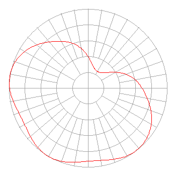
| Antenna Data for Antenna Id: 1003892 K36NX-D LD File: -0000055382 Electronics Research Inc. - AL4-W 36 Service: LD Standard Pattern: N |  | ||||||||||||||||||
| Azimuth | Ratio | Azimuth | Ratio | Azimuth | Ratio | Azimuth | Ratio | ||||||||||||
| 0 | 0.397 | 10 | 0.302 | 20 | 0.253 | 30 | 0.241 | ||||||||||||
| 40 | 0.253 | 50 | 0.302 | 60 | 0.397 | 70 | 0.510 | ||||||||||||
| 80 | 0.605 | 90 | 0.680 | 100 | 0.758 | 110 | 0.845 | ||||||||||||
| 120 | 0.922 | 130 | 0.975 | 140 | 0.997 | 150 | 0.990 | ||||||||||||
| 160 | 0.959 | 170 | 0.929 | 180 | 0.925 | 190 | 0.951 | ||||||||||||
| 200 | 0.985 | 210 | 1.000 | 220 | 0.985 | 230 | 0.951 | ||||||||||||
| 240 | 0.925 | 250 | 0.929 | 260 | 0.959 | 270 | 0.990 | ||||||||||||
| 280 | 0.997 | 290 | 0.975 | 300 | 0.922 | 310 | 0.845 | ||||||||||||
| 320 | 0.758 | 330 | 0.680 | 340 | 0.605 | 350 | 0.510 | ||||||||||||
Structure Registration Number 1041066 Structure Type: TOWER Registered To: SOUTH DAKOTA, STATE OF Structure Address: Mount Coolidge Custer, SD County Name: Custer County ASR Issued: 03/18/1998 Date Built: 09/20/1969 Site Elevation: 1831.9 m (6010 ft.) Structure Height: 99 m (325 ft.) Height Overall: 99 m (325 ft.) Overall Height AMSL: 1930.9 m (6335 ft.) FAA Determination: 06/18/1969 FAA Study #: MSP-69-199-OE Paint & Light FAA Chapters: 1, 3, 12, 21 RED LIGHTS/PAINT 43-44-43.0 N 103-28-52.0 W (NAD 83) 43-44-43.0 N 103-28-50.3 W (Converted to NAD 27) |
Cherry & Dakota Streets Box 5000 Vermillion, SD 57069 Phone: 605-677-6524 Government Entity | Title: Executive Director Date: 06/25/2018 Application Certifier South Dakota Board of Directors for Educational Telecommunic South Dakota Board of Directors for Educational Telecommunic Cherry & Dakota Streets Box 5000 Vermillion, SD 57069 Applicant Severn Ashes, Sr. South Dakota Public Broadcasting SD Public Broadcasting 555 N. Dakota Street, Box 5000 Vermillion, SD 57069 Staff Engineer Howard M. Liberman, Esq. Wilkinson Barker Knauer, LLP 1800 M Street, N.W. Suite 800N Washington, DC 20036 Douglas Lee Vernier Doug Vernier, Telecommunications Consultants Doug Vernier Telecommunications Consultants West Palm Beach, FL 33412 Engineering Consultant | |||||||||||||||||