FCCInfo.com
A Service of Cavell, Mertz & Associates, Inc.
(855) FCC-INFO
|
|
WHHB-CD from 12/14/2018 WHUA-CD from 12/13/2018 WYHB-CD from 10/16/2018 WHUA-CD from 10/16/2018 WHUA-LD from 10/16/2018 WYHB-CD from 04/23/2012 WYHB-LD from 03/16/2007 |
|
|
||||||||||||||||
|
|
Status: STA – Special Temporary Authority Application Accepted: 07/02/2018 STA Expires: 08/01/2029 File Number: 0000055684 FCC Website Links: LMS Facility Details This Application Other WYHB-CD Applications Including Superseded Applications Service Contour - Open Street Map or USGS Map (51 dBu) Service Contour - KML / Google Earth (51 dBu) Public Inspection Files Rabbit Ears Info Search for WYHB-CD Site Location: 35-12-26.0 N 85-16-52.0 W (NAD 83) Site Location: 35-12-25.7 N 85-16-52.1 W (Converted to NAD 27) ERP: 15 kW R/C AGL: 57.7 m (189 ft.) R/C AMSL: 671 m (2201 ft.) Emission Mask: Stringent Site Elevation: 613.3 m. (2012 ft.) Height Overall*: 76.2 m (250 ft.) (* As Filed In This Application, may differ from ASR Data, Below.) Directional Antenna - Antenna Make/Model: Scala K723147 PANEL ARRAY Antenna ID: 97660 | ||||||||||||||||||
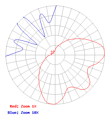
| Antenna Data for Antenna Id: 97660 WYHB-CD DC File: -0000055684 Scala - K723147 PANEL ARRAY Service: DC Standard Pattern: Y |  | ||||||||||||||||||
| Azimuth | Ratio | Azimuth | Ratio | Azimuth | Ratio | Azimuth | Ratio | ||||||||||||
| 0 | 0.092 | 10 | 0.148 | 20 | 0.203 | 30 | 0.272 | ||||||||||||
| 40 | 0.383 | 50 | 0.500 | 60 | 0.645 | 70 | 0.812 | ||||||||||||
| 80 | 0.971 | 90 | 0.998 | 100 | 0.889 | 110 | 0.730 | ||||||||||||
| 120 | 0.761 | 130 | 0.916 | 140 | 0.915 | 150 | 0.756 | ||||||||||||
| 160 | 0.730 | 170 | 0.889 | 180 | 0.998 | 182 | 1.000 | ||||||||||||
| 190 | 0.971 | 200 | 0.812 | 210 | 0.645 | 220 | 0.500 | ||||||||||||
| 230 | 0.382 | 240 | 0.272 | 250 | 0.203 | 260 | 0.148 | ||||||||||||
| 270 | 0.092 | 280 | 0.066 | 290 | 0.087 | 300 | 0.042 | ||||||||||||
| 310 | 0.101 | 320 | 0.100 | 330 | 0.042 | 340 | 0.087 | ||||||||||||
| 350 | 0.066 | ||||||||||||||||||
Structure Registration Number 1042762 Structure Type: Registered To: GREATER CHATTANOOGA PUBLIC TELEVISION CORPORATION Structure Address: Sawyer Cemetary Rd Signal Mountain, TN County Name: Hamilton County ASR Issued: 05/17/2022 Date Built: 06/02/1995 Site Elevation: 613.3 m (2012 ft.) Structure Height: 76.2 m (250 ft.) Height Overall: 76.2 m (250 ft.) Overall Height AMSL: 689.5 m (2262 ft.) FAA Determination: 06/06/1995 FAA Study #: MEM-OE-66-108 Paint & Light FAA Chapters: NONE 35-12-26.0 N 85-16-52.0 W (NAD 83) 35-12-25.7 N 85-16-52.1 W (Converted to NAD 27) |
295 Madison Avenue, 12th Floor New York, NY 10017 Phone: 954-606-5486 Corporation | Title: Licensee Date: 07/02/2018 Application Certifier Wyhb TV 44 P O Box 272 Lookout Mountain, TN 37350 Applicant Ying Benns None P O Box 272 Lookout Mountain, TN 37350 Paul Feldman Fletcher Heald & Hildreth 1300 North 17th St. Arlington, VA 22209 Attorney Dan Kirkpatrick Fletcher Heald &Hildreth 1300 North 17th St. Arlington, VA 22209 Attorney | |||||||||||||||||