FCCInfo.com
A Service of Cavell, Mertz & Associates, Inc.
(855) FCC-INFO
|
|
KGSC-LP from 05/22/2007 K47IU from 03/15/2004 |
Virtual Channel 32 |
|
||||||||||||||||
|
|
Status: LIC Application Accepted: 08/20/2018 License Expires: 10/01/2030 File Number: 0000059062 FCC Website Links: LMS Facility Details This Application Other KGSC-LD Applications Including Superseded Applications Service Contour - Open Street Map or USGS Map (51 dBu) Service Contour - KML / Google Earth (51 dBu) Rabbit Ears Info Search for KGSC-LD Site Location: 41-09-34.5 N 104-43-19.8 W (NAD 83) Site Location: 41-09-34.6 N 104-43-17.9 W (Converted to NAD 27) ERP: 10 kW Polarization: Horizontally polarized R/C AGL: 31.8 m (104 ft.) R/C AMSL: 1896.5 m (6222 ft.) Emission Mask: Simple Site Elevation: 1864.7 m. (6118 ft.) Height Overall*: 56 m (184 ft.) (* As Filed In This Application, may differ from ASR Data, Below.) Directional Antenna - Antenna Make/Model: Propagation System Inc PSILP16OI Antenna ID: 20399 Polarization: Horizontally polarized | ||||||||||||||||||
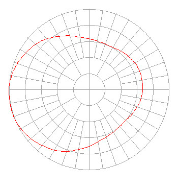
| Antenna Data for Antenna Id: 20399 KGSC-LD LD File: -0000059062 Propagation System Inc - PSILP16OI Service: LD Standard Pattern: Y Pattern and Field Values Include a 260° Clockwise Rotation |  | ||||||||||||||||||
| Azimuth | Ratio | Azimuth | Ratio | Azimuth | Ratio | Azimuth | Ratio | ||||||||||||
| 0 | 0.630 | 10 | 0.610 | 20 | 0.600 | 30 | 0.600 | ||||||||||||
| 40 | 0.620 | 50 | 0.640 | 60 | 0.660 | 70 | 0.670 | ||||||||||||
| 80 | 0.670 | 90 | 0.670 | 100 | 0.660 | 110 | 0.640 | ||||||||||||
| 120 | 0.620 | 130 | 0.600 | 140 | 0.600 | 150 | 0.610 | ||||||||||||
| 160 | 0.630 | 170 | 0.660 | 180 | 0.710 | 190 | 0.760 | ||||||||||||
| 200 | 0.820 | 210 | 0.870 | 220 | 0.910 | 230 | 0.950 | ||||||||||||
| 240 | 0.980 | 250 | 1.000 | 260 | 1.000 | 270 | 1.000 | ||||||||||||
| 280 | 0.980 | 290 | 0.950 | 300 | 0.910 | 310 | 0.870 | ||||||||||||
| 320 | 0.820 | 330 | 0.760 | 340 | 0.710 | 350 | 0.660 | ||||||||||||
Structure Registration Number 1008318 Structure Type: Registered To: RF Towers, LLC Structure Address: 7011 Dell Range Blvd Cheyenne, WY County Name: Laramie County ASR Issued: 02/10/2024 Date Built: 12/19/2012 Site Elevation: 1864.7 m (6118 ft.) Structure Height: 55.2 m (181 ft.) Height Overall: 56 m (184 ft.) Overall Height AMSL: 1920.7 m (6302 ft.) FAA Determination: 04/09/2012 FAA Study #: 2012-ANM-789-OE FAA Circular #: 70/7460-1K Paint & Light FAA Chapters: 4, 8, 12 OM&L to remain the same as prior study = A MED-DUAL SYSTEM 41-09-34.5 N 104-43-19.8 W (NAD 83) 41-09-34.6 N 104-43-17.9 W (Converted to NAD 27) |
2201 East Wyoming Avenue El Paso, TX 79903 Phone: 915-532-8588 Not-for-Profit | Title: Vice President General Manager Date: 08/20/2018 Application Certifier The Spirit of the Lord Ministries Channel 38 Christian Television 2201 East Wyoming Avenue El Paso, TX 79903 Applicant Susan Hansen B. W. St. Clair 6868 Vivian St. Arvada, CO 80004 Consultant | |||||||||||||||||