FCCInfo.com
A Service of Cavell, Mertz & Associates, Inc.
(855) FCC-INFO
|
|
KNAN-TV from ??? |
Virtual Channel 39 |  |
|
|||||||||||||||||
|
|
Status: LIC Application Accepted: 10/30/2018 License Expires: 06/01/2029 File Number: 0000063151 FCC Website Links: LMS Facility Details This Application Other KMCT-TV Applications Including Superseded Applications Service Contour - Open Street Map or USGS Map (41 dBu) Service Contour - KML / Google Earth (41 dBu) Public Inspection Files Rabbit Ears Info Search for KMCT-TV Site Location: 32-30-21.2 N 92-08-55.6 W (NAD 83) Site Location: 32-30-20.7 N 92-08-55.1 W (Converted to NAD 27) ERP: 25 kW Polarization: Horizontally polarized HAAT: 92 m (302 ft.) Electrical Beam Tilt: 0.25 degrees R/C AGL: 97 m (318 ft.) R/C AMSL: 118 m (387 ft.) Site Elevation: 21 m. (69 ft.) Height Overall*: 105.1 m (345 ft.) (* As Filed In This Application, may differ from ASR Data, Below.) Directional Antenna - Antenna Make/Model: Propagation System Inc PSILP12OI Antenna ID: 20364 Polarization: Horizontally polarized | ||||||||||||||||||||
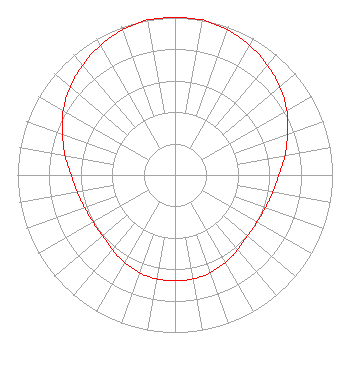
| Antenna Data for Antenna Id: 20364 KMCT-TV DT File: -0000063151 Propagation System Inc - PSILP12OI Service: DT Standard Pattern: Y |  | ||||||||||||||||||||
| Azimuth | Ratio | Azimuth | Ratio | Azimuth | Ratio | Azimuth | Ratio | ||||||||||||||
| 0 | 1.000 | 10 | 1.000 | 20 | 0.980 | 30 | 0.950 | ||||||||||||||
| 40 | 0.910 | 50 | 0.870 | 60 | 0.820 | 70 | 0.760 | ||||||||||||||
| 80 | 0.710 | 90 | 0.660 | 100 | 0.630 | 110 | 0.610 | ||||||||||||||
| 120 | 0.600 | 130 | 0.600 | 140 | 0.620 | 150 | 0.640 | ||||||||||||||
| 160 | 0.660 | 170 | 0.670 | 180 | 0.670 | 190 | 0.670 | ||||||||||||||
| 200 | 0.660 | 210 | 0.640 | 220 | 0.620 | 230 | 0.600 | ||||||||||||||
| 240 | 0.600 | 250 | 0.610 | 260 | 0.630 | 270 | 0.660 | ||||||||||||||
| 280 | 0.710 | 290 | 0.760 | 300 | 0.820 | 310 | 0.870 | ||||||||||||||
| 320 | 0.910 | 330 | 0.950 | 340 | 0.980 | 350 | 1.000 | ||||||||||||||
Structure Registration Number 1296986 Structure Type: GTOWER Registered To: American Towers LLC Structure Address: Almost 1/4 Mile E. Of I-20, S Of Parkwood Dr. West Monroe, LA County Name: Ouachita Parish ASR Issued: 10/02/2017 Date Built: 10/05/2015 Site Elevation: 21 m (69 ft.) Structure Height: 103.6 m (340 ft.) Height Overall: 105.1 m (345 ft.) Overall Height AMSL: 126.1 m (414 ft.) FAA Determination: 05/19/2015 FAA Study #: 2015-ASW-3685-OE FAA Circular #: 70/7460-1K Paint & Light FAA Chapters: 4, 8, 12 Removed expiration date from determination. Scenario 1./jjs/case#635066 32-30-21.2 N 92-08-55.6 W (NAD 83) 32-30-20.7 N 92-08-55.1 W (Converted to NAD 27) |
3409 Rutherford Rd Ext. Taylors, SC 29687 Phone: 864-244-1616 Limited Liability Company | Title: Secretary Date: 10/30/2018 Application Certifier The Voice Network First Assembly of God of West Monroe Greenville, SC, SC 29602 Applicant Joseph C. Chautin, III Hardy, Carey, Chautin & Balkin, LLP 1080 West Causeway Approach Mandeville, LA 70471 Esq. Louis R Dutreil, Jr Dutreil Lundin & Rackley Inc 3135 Southgate Circle Sarasota, FL 34239 Technical Consultant | |||||||||||||||||||
| |||||||||||||||||||||