FCCInfo.com
A Service of Cavell, Mertz & Associates, Inc.
(855) FCC-INFO
|
|
KOCV-TV from 12/31/1984 840215LB from ??? |
Virtual Channel 36 |  |
|
|||||||||||||||||
|
|
Status: LIC Application Accepted: 12/04/2018 License Expires: 08/01/2030 File Number: 0000063946 FCC Website Links: LMS Facility Details This Application Other KPBT-TV Applications Including Superseded Applications Service Contour - Open Street Map or USGS Map (41 dBu) Service Contour - KML / Google Earth (41 dBu) Public Inspection Files Rabbit Ears Info Search for KPBT-TV Site Location: 32-05-11.0 N 102-17-12.0 W (NAD 83) Site Location: 32-05-10.6 N 102-17-10.5 W (Converted to NAD 27) ERP: 515 kW Polarization: Elliptically polarized HAAT: 224 m (735 ft.) Electrical Beam Tilt: 0.75 degrees R/C AGL: 231.6 m (760 ft.) R/C AMSL: 1118.3 m (3669 ft.) Site Elevation: 886.7 m. (2909 ft.) Height Overall*: 345 m (1132 ft.) (* As Filed In This Application, may differ from ASR Data, Below.) Directional Antenna - Antenna Make/Model: R.F. Systems SAA28-ATW_P3-J300-ES6R-28 Antenna ID: 1004386 Polarization: Elliptically polarized | ||||||||||||||||||||
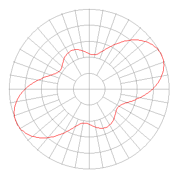
| Antenna Data for Antenna Id: 1004386 KPBT-TV DT File: -0000063946 R.F. Systems - SAA28-ATW_P3-J300-ES6R-28 Service: DT Standard Pattern: N Pattern and Field Values Include a 155° Clockwise Rotation |  | ||||||||||||||||||||
| Azimuth | Ratio | Azimuth | Ratio | Azimuth | Ratio | Azimuth | Ratio | ||||||||||||||
| 5 | 0.428 | 15 | 0.457 | 25 | 0.567 | 35 | 0.719 | ||||||||||||||
| 45 | 0.863 | 55 | 0.964 | 65 | 1.000 | 75 | 0.964 | ||||||||||||||
| 85 | 0.863 | 95 | 0.719 | 105 | 0.567 | 115 | 0.457 | ||||||||||||||
| 125 | 0.428 | 135 | 0.462 | 145 | 0.507 | 155 | 0.526 | ||||||||||||||
| 165 | 0.507 | 175 | 0.462 | 185 | 0.428 | 195 | 0.457 | ||||||||||||||
| 205 | 0.567 | 215 | 0.719 | 225 | 0.863 | 235 | 0.964 | ||||||||||||||
| 245 | 1.000 | 255 | 0.964 | 265 | 0.863 | 275 | 0.719 | ||||||||||||||
| 285 | 0.567 | 295 | 0.457 | 305 | 0.428 | 315 | 0.462 | ||||||||||||||
| 325 | 0.507 | 335 | 0.526 | 345 | 0.507 | 355 | 0.462 | ||||||||||||||
Structure Registration Number 1053361 Structure Type: GTOWER Registered To: Subcarrier Communications Inc Structure Address: 3 Mi N Of Int Fm 1788 & Tx 158 Gardendale, TX County Name: Midland County ASR Issued: 06/07/2017 Date Built: 10/01/2017 Site Elevation: 886.7 m (2909 ft.) Structure Height: 314 m (1030 ft.) Height Overall: 345 m (1132 ft.) Overall Height AMSL: 1231.7 m (4041 ft.) FAA Determination: 02/14/2017 FAA Study #: 2017-ASW-1003-OE FAA Circular #: 70/7460-1L Paint & Light FAA Chapters: 3, 4, 5, 12 PRIOR STUDY 1998-ASW-4097-OE 32-05-11.0 N 102-17-12.0 W (NAD 83) 32-05-10.6 N 102-17-10.5 W (Converted to NAD 27) |
Midland, TX 79708 Phone: 432-563-5728 Not-for-Profit | Title: Board Chair Date: 12/04/2018 Application Certifier KPBT-TV Permian Basin Public Telecommunications, Inc. P.O. Box 8940 Midland, TX 79708 Applicant Lawrence M. Miller Garvey Schubert Barer 1000 Potomac Street, NW Suite 200 Washington, DC 20007 Attorney David Sanderford Marsand, Inc. 1957 Reynolds Dr Azle, TX 76020 | |||||||||||||||||||